

Compliance Assessment Plan - Fremantle Ports
Compliance Assessment Plan - Fremantle Ports
Compliance Assessment Plan - Fremantle Ports

Create successful ePaper yourself
Turn your PDF publications into a flip-book with our unique Google optimized e-Paper software.
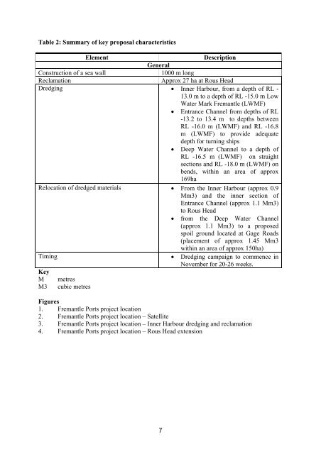
Table 2: Summary of key proposal characteristicsElementDescriptionGeneralConstruction of a sea wall1000 m longReclamationApprox 27 ha at Rous HeadDredging • Inner Harbour, from a depth of RL -13.0 m to a depth of RL -15.0 m LowWater Mark <strong>Fremantle</strong> (LWMF)• Entrance Channel from depths of RL-13.2 to 13.4 m to depths betweenRL -16.0 m (LWMF) and RL -16.8m (LWMF) to provide adequatedepth for turning ships• Deep Water Channel to a depth ofRL -16.5 m (LWMF) on straightsections and RL -18.0 m (LWMF) onbends, within an area of approx169haRelocation of dredged materials • From the Inner Harbour (approx 0.9Mm3) and the inner section ofEntrance Channel (approx 1.1 Mm3)to Rous Head• from the Deep Water Channel(approx 1.1 Mm3) to a proposedspoil ground located at Gage Roads(placement of approx 1.45 Mm3within an area of approx 150ha)Timing • Dredging campaign to commence inNovember for 20-26 weeks.KeyM metresM3 cubic metresFigures1. <strong>Fremantle</strong> <strong>Ports</strong> project location2. <strong>Fremantle</strong> <strong>Ports</strong> project location – Satellite3. <strong>Fremantle</strong> <strong>Ports</strong> project location – Inner Harbour dredging and reclamation4. <strong>Fremantle</strong> <strong>Ports</strong> project location – Rous Head extension7


