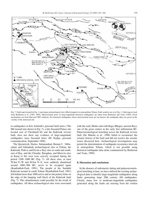
578M. Berberian, R.S. Yeats / Journal of Structural Geology 23 (2001) 563±584Mosque, then known as the `Great Mosque', 14 years beforethe earthquake and described it as ªthe largest arch to beseen in all Khorasan provinceº. Therefore, the SeljuqMosque was in good condition at least until AD 1052.Although this destruction, documented by the archaeologicalevidence and written documents, is clearly related toan earthquake, it is not certain which of the active faults nearQa'en was the source of the earthquake (see Berberian et al.,1999; Berberian and Yeats, 1999) (Fig. 6). However, thecomplete destruction of the Seljuq Mosque suggests thatthe earthquake source was close to the city, thus rejectingthe Dasht-e-Bayaz and Abiz faults as possible sources (Fig.6). The Avash left-lateral strike-slip fault, in the mountainsapproximately 9 km north of Qa'en, the Pavak/Boznabadright-lateral strike-slip fault, located 20 km east of Qa'en,and the southeastern segment of the Ferdows reverse fault,located 26 km southwest of Qa'en, are candidate sources forthe May 1066 event (Fig. 6). The Avash Fault, 25 km long,seems to be too short for such a large-magnitude earthquake.In this case the Pavak/Boznabad fault system, with `Kuh-e-Shekasteh Barqu' [lit. the `Barqu Broken/Faulted Mountain']on its eastern side, being 6 km closer to Qa'en than theFerdows Fault, is a more suitable candidate fault for theAD 1066 earthquake (Fig. 6). The Ferdows Friday Mosque(AD 1200) and the Soltan Mohammad `Abed Mausoleum ofKakhk (AD 1553) post-date the 1066 event, and the effect ofthis earthquake on these towns is therefore not known.6.2. Post-AD 1066 earthquakesApparently, an earthquake in AD 1238 damaged Gonabad(83 km NW of Qa'en); however, the Gonabad Seljuq Jame'Mosque (built in AD 1212) presumably escaped destruction(Tabandeh, 1969). Due to uncritical use of second-handsources, this event was confused with the May 1066 eventof Qa'en in ®gure 5 of Berberian and Yeats (1999). Reexaminationof the original texts shows no indication thatthe AD 1238 event affected Qa'en (Fig. 6).According to Khandmir (1550), Rumlu (1577), and Qomi(1591) ªAn earthquake on 1549.02.15 destroyed ®vevillages at Bozhd, Birjand, Siojan, Taqab, and Shahzileh[Fig. 6 shows the approximate meizoseismal area]. Allhouses were destroyed, and nobody escaped the earthquake.The shock was weaker at Khosf (35 km west of Birjand),and the death toll was estimated between 2000 to 3000people. The earthquake did not damage Qa'enº (Khandmir,1550). The North Birjand Fault seems to be the source ofthis event (Fig. 6).The winter AD 1675 earthquake allegedly ruinedGonabad with major loss of life, although the GonabadJame' Mosque withstood the shock (Tabandeh, 1969). TheGonabad or the Bidokht faults (with fresh displacementsvisible on aerial photograph nos. 29305 and 29307, WorldwideAerial Surveys, Inc., project 158) are possible sourcesof the AD 1675 and/or AD 1238 earthquakes (Fig. 6). Noevidence of the earthquake is reported from Qa'en. Aninscription in Qa'en Mosque records only restoration workin AD 1675, with no reference to any earthquakes. It isimportant to note that the two Gonabad earthquakes ofAD 1238 and AD 1675, reported by Tabandeh (1969),were based on local tradition and require con®rmation.An earthquake in AD 1847 cracked the rear wall of theQa'en Timurid Friday Mosque, and it became necessary toprop it up with buttresses (Smith, 1876). The source of thisevent is also unknown.Finally, an earthquake in 1923.11.29 (M 5.6) wasreported to have caused widespread damage in the areaSE of Qa'en (exact location unknown). Many houses wereruined, but there were no casualties (Stratil-Sauer, 1950;Ambraseys and Melville, 1977). International SeismologicalSummary places the epicenter of this event near Zabol,338 km SE of Qa'en.The Timurid (1368) Friday Mosque of Qa'en is stillstanding, suggesting that Qa'en did not suffer severedamage or destruction during the AD 1549 (Birjand), AD1675 (Gonabad), and AD 1847 earthquakes (Table 4).Hence, despite several references to historical destructionof Qa'en, the sources of these events were farther fromQa'en than the May AD 1066 event (Fig. 6). Albeitclarifying the confusion on the historical earthquakes inthe Qa'en region, and utilizing archaeological evidencefor the historically recorded event of 1066, palaeoseismologicaltrench investigations are necessary to clarify theambiguities associated with the seismic sources of severalhistorical earthquakes in this area.7. Earthquakes in the capital city of TehranThe number of archaeological sites and historical monumentsclose to active faults (Fig. 1) indicates that futurestudies relating archaeological data to earthquakes arewarranted, particularly near Tehran, where one-®fth of the60 million population of Iran is at risk. For example, theCheshmeh'Ali mound at Ray, now the southern quarter ofmetropolitan Tehran, and the Qaytariyeh mound of c. 1200±1000 BC in central east Tehran (Kambakhsh-Fard, 1991)should be investigated (Fig. 7). These sites are close to theNorth Ray, South Ray, Kahrizak, Parchin, North Tehran,and Mosha active reverse faults (Berberian et al., 1985;Berberian and Yeats, 1999), and the area has been affectedby destructive earthquakes in 312±281 BC (M , 7.6), AD743 (M , 7.2), AD 855 (M , 7.1), AD 864 (.5.3), AD 958(M , 7.7), AD 1177 (M , 7.2), AD 1665 (M , 6.5), andAD 1830 (M , 7.1). The Cheshmeh'Ali site (along theNorth Ray Fault) was suddenly abandoned in the thirdmillennium BC (Schmidt, 1940), was again inhabited atthe end of the second millennium BC, and later used byParthians (312 BC±AD 224) and Sassanids (AD 224±642). (Communications with Renata Holod and FredrikHiebert of the University of Pensylvania, Philadelphia, inFebruary 2000 indicated that there are no speci®c references
M. Berberian, R.S. Yeats / Journal of Structural Geology 23 (2001) 563±584 579Fig. 7. Fault map (located in Fig. 1) and major archaeological sites (®lled triangles) in metropolitan Tehran. Fault symbols are as in Fig. 1. Fault map revisedfrom Berberian et al. (1983, 1985). Meizoseismal areas of large-magnitude historical earthquakes are taken from Berberian and Yeats (1999). Focalmechanisms are from Harvard CMT solutions. For historical earthquakes whose meizoseismal areas are not known, the earthquake dates are given in thevicinity of the destroyed site.to earthquakes in Eric Schmidt's personal ®eld notes.) TheMil mound (not shown in Fig. 7), a late Sassanid Palace sitelocated east of Cheshmeh'Ali and the Kahrizak reversefault, does not show any evidence of large-magnitudeearthquakes since Sassanid times (M. Kadjar, personalcommunication, September 1998).The Qaytariyeh, Darrus, Saltanatabad, Bustan-5, `Abbasabad,and Galanduak archaeological sites at Tehran, theKahrizak, Pishva, and Eivan-e-Kay sites at south and southeastof Ray, and the Chendar, Baraghan, and Khorvin sitesat Karaj to the west were actively occupied during theperiod 1200±1000 BC (Fig. 7). All these sites, at least50 km E±W and 40 km N±S, were suddenly abandonedaround 1000±900 BC, never to be occupied again(Kambakhsh-Fard, 1991). The people at the SartakhtKahrizak mound in south Tehran (Kambakhsh-Fard, 1991)left behind more than 1000 active and in situ pottery kilns onthe edge of the hanging wall block of the Kahrizak fault(Fig. 7). This abandonment could possibly be the result ofearthquakes. All these archaeological sites were associatedwith the early Medes and with Raga (Rhages; ancient Ray),one of the great centers in the early ®rst millennium BC.Palaeoseismological trenching across the Kahrizak reversefault (De Martini et al., 1998) failed to reconstruct theseismic history of the fault and did not resolve the seismicissues discussed here. Archaeological investigations maypermit the determination of earthquake recurrence intervalsin metropolitan Tehran, which is not possible usinghistorical earthquake data alone (summarized by Berberianand Yeats, 1999).8. Discussion and conclusionsIn the absence of radiometric dating and palaeoseismologicaltrenching in Iran, we have utilized the existing archaeologicaldata to identify large-magnitude earthquakes alongfaults generating large 20th century AD earthquakes.Clearly, many low- to moderate-magnitude earthquakesgenerated along the faults are missing from the written