PDF COPY - Manuel berberian
PDF COPY - Manuel berberian
PDF COPY - Manuel berberian

Create successful ePaper yourself
Turn your PDF publications into a flip-book with our unique Google optimized e-Paper software.
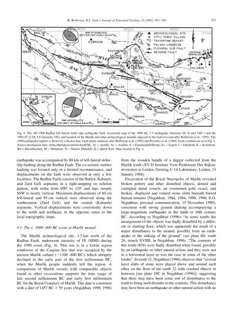
M. Berberian, R.S. Yeats / Journal of Structural Geology 23 (2001) 563±584 571Fig. 4. The AD 1990 Rudbar left-lateral strike-slip earthquake fault, isoseismal map of the 1990 M w 7.3 earthquake (intensity IX±X and VIII 1 ) and the1983.07.22 M s 5.6 (intensity VII), and location of the Marlik and other archaeological mounds adjacent to the fault (revised after Berberian et al., 1992). The1990 earthquake rupture is shown by a thicker line. Fault plane solutions after Berberian et al. (1992) and Priestley et al. (1994). Fault symbols are as in Fig. 1.Source mechanism data: strike/dip/rake/centroid depth/M o .Arˆ Aushki; As ˆ Asiabar; E ˆ Emamzadeh/Shrine; Es ˆ Espeli; I ˆ Ishehkuh; K ˆ Kelishom;Kh ˆ Khoshkushan; M ˆ Mulameh; N ˆ Nauruz Mahaleh; Q ˆ Qaleh Kuti. Map located in Fig. 1.earthquake was accompanied by 80 km of left-lateral strikeslipfaulting along the Rudbar Fault. The co-seismic surfacefaulting was located only in a limited reconnaissance, anddisplacements on the fault were observed at only a fewlocalities. The Rudbar Fault consists of the Baklor, Kabateh,and Zard Geli segments in a right-stepping en eÂchelonpattern, with strike from 0908 to 1208 and dips steeplySSW to nearly vertical. Maximum displacements of 60 cmleft-lateral and 95 cm vertical were observed along thesoutheastern (Zard Geli) and the central (Kabateh)segments. Vertical displacements were consistently downto the north and northeast, in the opposite sense to thelocal topographic slope.4.1. The c. 1000±800 BC event at Marlik moundThe Marlik archaeological site, 3.5 km north of theRudbar Fault, underwent intensity of IX (MMI) duringthe 1990 event (Fig. 4). This site is in a fertile regionsouthwest of the Caspian Sea that was occupied by theancient Marlik culture (,1300±800 BC), which abruptlydeclined in the early part of the ®rst millennium BC,when the Marlik people suddenly left the region. Acomparison of Marlik vessels with comparable objectsfound in other excavations supports the time range oflate second millennium BC and early ®rst millenniumBC for the Royal Cemetery of Marlik. This date is consistentwith a date of 1457 BC ^ 55 years (Negahban, 1990, 1996)from the wooden handle of a dagger collected from theMarlik tomb (XV-D Instituut Voor Prehistorie Der Rijksuniversiteitte Leiden, Groning C-14 Laboratory, Leiden, 15January 1968).Excavation of the Royal Necropolis of Marlik revealedbroken pottery and other disturbed objects, dented andcrumpled metal vessels, an overturned gold vessel, andbroken, displaced and rotated stone slabs beneath buriedhuman remains (Negahban, 1964, 1984, 1990, 1996; E.O.Negahban, personal communication, 15 November 1990),consistent with strong ground shaking accompanying alarge-magnitude earthquake in the ninth or 10th centuryBC. According to Negahban (1996): ªin some tombs thearrangement of the objects was badly disturbed by a differentor slanting ¯oor, which was apparently the result of amajor disturbance to the mound, possibly from an earthquakeor the sinking of the groundº (see plate 8D, tomb26, trench XVIIB, in Negahban, 1996). ªThe contents ofthis tomb (#26) were badly disturbed when found, possiblyby an earthquake or other natural action, and they were notin a horizontal layer as was the case in some of the othertombsº. In tomb 32, Negahban (1996) observes that ªseverallayer slabs of stone were placed above and around eachother on the ¯oor of the tomb 32 with crushed objects inbetween [see plate 10C in Negahban (1996)], suggestingthat there may have been some sort of disturbance to thetomb to bring such disorder to the contents. This disturbancemay have been an earthquake or other natural action with no