County Wildife Site Criteria for Cornwall Appendices
County Wildife Site Criteria for Cornwall Appendices
County Wildife Site Criteria for Cornwall Appendices

Create successful ePaper yourself
Turn your PDF publications into a flip-book with our unique Google optimized e-Paper software.
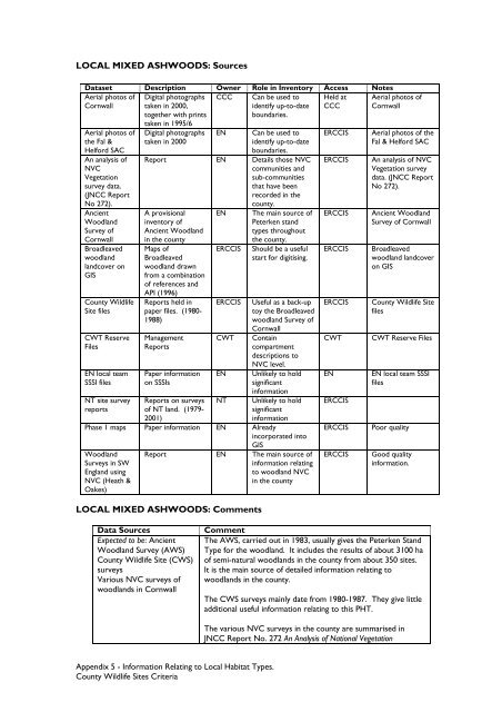
LOCAL MIXED ASHWOODS: SourcesDataset Description Owner Role in Inventory Access NotesAerial photos ofCCCHeld at<strong>Cornwall</strong>CCCAerial photos ofthe Fal &Hel<strong>for</strong>d SACAn analysis ofNVCVegetationsurvey data.(JNCC ReportNo 272).AncientWoodlandSurvey of<strong>Cornwall</strong>Broadleavedwoodlandlandcover onGIS<strong>County</strong> Wildlife<strong>Site</strong> filesCWT ReserveFilesEN local teamSSSI filesNT site surveyreportsDigital photographstaken in 2000,together with printstaken in 1995/6Digital photographstaken in 2000ENCan be used toidentify up-to-dateboundaries.Can be used toidentify up-to-dateboundaries.Report EN Details those NVCcommunities andsub-communitiesthat have beenrecorded in thecounty.A provisionalinventory ofAncient Woodlandin the countyMaps ofBroadleavedwoodland drawnfrom a combinationof references andAPI (1996)Reports held inpaper files. (1980-1988)ManagementReportsPaper in<strong>for</strong>mationon SSSIsReports on surveysof NT land. (1979-2001)ENERCCISERCCISCWTENThe main source ofPeterken standtypes throughoutthe county.Should be a usefulstart <strong>for</strong> digitising.Useful as a back-uptoy the Broadleavedwoodland Survey of<strong>Cornwall</strong>Containcompartmentdescriptions toNVC level.Unlikely to holdsignificantin<strong>for</strong>mationUnlikely to holdsignificantin<strong>for</strong>mationPhase 1 maps Paper in<strong>for</strong>mation EN Alreadyincorporated intoGISWoodlandSurveys in SWEngland usingNVC (Heath &Oakes)NTReport EN The main source ofin<strong>for</strong>mation relatingto woodland NVCin the countyLOCAL MIXED ASHWOODS: CommentsERCCISERCCISERCCISERCCISERCCISCWTENERCCISERCCISERCCISAerial photos of<strong>Cornwall</strong>Aerial photos of theFal & Hel<strong>for</strong>d SACAn analysis of NVCVegetation surveydata. (JNCC ReportNo 272).Ancient WoodlandSurvey of <strong>Cornwall</strong>Broadleavedwoodland landcoveron GIS<strong>County</strong> Wildlife <strong>Site</strong>filesCWT Reserve FilesEN local team SSSIfilesPoor qualityGood qualityin<strong>for</strong>mation.Data SourcesExpected to be: AncientWoodland Survey (AWS)<strong>County</strong> Wildlife <strong>Site</strong> (CWS)surveysVarious NVC surveys ofwoodlands in <strong>Cornwall</strong>CommentThe AWS, carried out in 1983, usually gives the Peterken StandType <strong>for</strong> the woodland. It includes the results of about 3100 haof semi-natural woodlands in the county from about 350 sites.It is the main source of detailed in<strong>for</strong>mation relating towoodlands in the county.The CWS surveys mainly date from 1980-1987. They give littleadditional useful in<strong>for</strong>mation relating to this PHT.The various NVC surveys in the county are summarised inJNCC Report No. 272 An Analysis of National VegetationAppendix 5 - In<strong>for</strong>mation Relating to Local Habitat Types.<strong>County</strong> Wildlife <strong>Site</strong>s <strong>Criteria</strong>