- Page 1 and 2:
HeadingCounty Wildife SiteCriteria
- Page 3 and 4:
PENWITHP/K 1P/K 2P3Hayle Estuary an
- Page 5:
K17K18K19K20K21K22K23K24K25K26K/P 2
- Page 8 and 9:
R5R6R7R8R9R10R11R12R13R 15.2R/CK 16
- Page 10 and 11:
CN/NC 8CN/NC 9CN 10CN 11CN 12CN 13C
- Page 12 and 13:
NC/CN 7 NNC/CN 7 SNC/CN 8NC/CN 9NC
- Page 14 and 15:
Appendix 2The Selection of Local Si
- Page 16 and 17:
However, it is not a significant co
- Page 18 and 19:
Where any area has less than ½ of
- Page 20 and 21:
West Looe to Watergatehttp://cwtdev
- Page 22 and 23:
Appendix 4Information Relating to P
- Page 24 and 25:
Upland flushes, fens and swamps PHT
- Page 26 and 27: COASTAL SALTMARSH: SourcesDataset D
- Page 28 and 29: COASTAL SAND DUNES: SourcesDataset
- Page 30 and 31: COASTAL VEGETATED SHINGLE: SourcesD
- Page 32 and 33: ESTUARINE ROCKY HABITATS PHTGeneral
- Page 34 and 35: INTERTIDAL MUDFLATS PHTGeneral Desc
- Page 36 and 37: MAERL BEDS PHTGeneral DescriptionMa
- Page 38 and 39: MUD HABITATS IN DEEP WATER PHTGener
- Page 40 and 41: Sabellaria alveolata REEFS: Sources
- Page 42 and 43: SALINE LAGOONS: SourcesDataset Desc
- Page 44 and 45: SEAGRASS BEDS: SourcesDataset Descr
- Page 46 and 47: SUBTIDAL SANDS AND GRAVELS PHTGener
- Page 48 and 49: LOWLAND MIXED DECIDUOUS WOODLAND PH
- Page 50 and 51: LOWLAND MIXED DECIDUOUS WOODLAND: C
- Page 52 and 53: TRADITIONAL ORCHARDS PHTGeneral Des
- Page 54 and 55: UPLAND MIXED ASHWOODS PHTGeneral De
- Page 56 and 57: UPLAND MIXED ASHWOODS: CommentsData
- Page 58 and 59: UPLAND OAKWOOD PHTGeneral Descripti
- Page 60 and 61: UPLAND OAKWOOD: CommentsData Source
- Page 62 and 63: WET WOODLAND PHTGeneral Description
- Page 64 and 65: WET WOODLAND: CommentsData SourcesA
- Page 66 and 67: WOOD-PASTURE AND PARKLAND PHTGenera
- Page 68 and 69: The National DefinitionGoodReliabil
- Page 70 and 71: ARABLE FIELD MARGINS PHTGeneral Des
- Page 72 and 73: COASTAL AND FLOODPLAIN GRAZING MARS
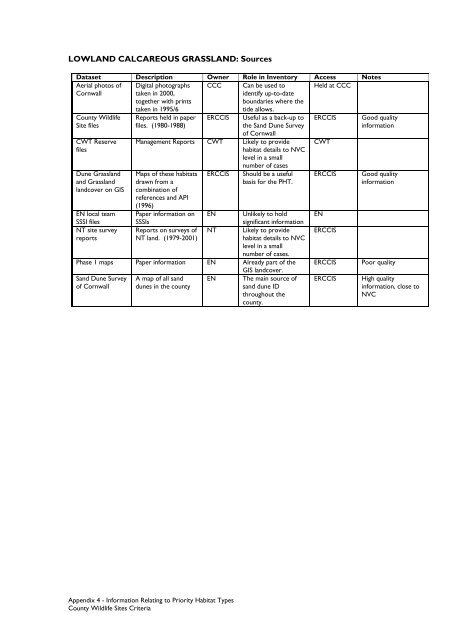
- Page 74 and 75: LOWLAND MEADOWS: SourcesDataset Des
- Page 78 and 79: LOWLAND CALCAREOUS GRASSLAND: Comme
- Page 80 and 81: LOWLAND DRY ACID GRASSLAND: Sources
- Page 82 and 83: LOWLAND HEATHLAND PHTGeneral Descri
- Page 84 and 85: LOWLAND HEATHLAND: CommentsData Sou
- Page 86 and 87: UPLAND HEATHLAND: SourcesDataset De
- Page 88 and 89: LOWLAND FENS PHTGeneral Description
- Page 90 and 91: PURPLE MOOR GRASS AND RUSH PASTURES
- Page 92 and 93: PURPLE MOOR GRASS AND RUSH PASTURES
- Page 94 and 95: REEDBEDS: SourcesDataset Descriptio
- Page 96 and 97: UPLAND FLUSHES, FENS AND SWAMPS: po
- Page 98 and 99: BLANKET BOG: SourcesDataset Descrip
- Page 100 and 101: EUTROPHIC STANDING WATER PHTGeneral
- Page 102 and 103: MESOTROPHIC LAKES PHTGeneral Descri
- Page 104 and 105: OLIGOTROPHIC AND DYSTROPHIC LAKES P
- Page 106 and 107: PONDS PHTGeneral DescriptionThis PH
- Page 108 and 109: RIVERS PHTGeneral DescriptionThe Ri
- Page 110 and 111: OPEN MOSAIC HABITATS ON PREVIOUSLY
- Page 112 and 113: This appendix provides a more detai
- Page 114 and 115: LOCAL ANCIENT WOODLANDSGeneral Desc
- Page 116 and 117: LOCAL ANCIENT WOODLANDS: CommentsDa
- Page 118 and 119: LOCAL MIXED ASHWOODS: SourcesDatase
- Page 120 and 121: LOCAL PARKLANDSGeneral DescriptionT
- Page 122 and 123: The National DefinitionGoodReliabil
- Page 124 and 125: LOCAL BOUNDARIES: SourcesDataset De
- Page 126 and 127:
LOCAL FLOODPLAIN GRASSLANDS: Source
- Page 128 and 129:
LOCAL LOWLAND MEADOWSGeneral Descri
- Page 130 and 131:
LOCAL LOWLAND MEADOWS: CommentsData
- Page 132 and 133:
UPLAND DRY ACID GRASSLAND: SourcesD
- Page 134 and 135:
LOCAL PONDSGeneral DescriptionThe n
- Page 136 and 137:
Appendix 6Information Relating to S
- Page 138 and 139:
Monotropa hypopitysMuscari neglectu
- Page 140 and 141:
FRESHWATER ALGAE, FUNGI AND LICHENS
- Page 142 and 143:
BRYOPHYTESThese criteria are direct
- Page 144 and 145:
*Calliergon sarmentosum 50**Calypog
- Page 146 and 147:
Pottia commutata = Microbryum daval
- Page 148 and 149:
Moths:Acronicta psi Grey DaggerAcro
- Page 150 and 151:
BUTTERFLIESBAP species and butterfl
- Page 152 and 153:
DRAGONFLIES AND DAMSELFLIES (ODONAT
- Page 154 and 155:
FISHGainey, in CISFBR (2009), state
- Page 156 and 157:
Sites with significant Amphibian as
- Page 158 and 159:
Turdus torquatus torquatus Ring Ouz
- Page 160 and 161:
Table of Thresholds for wintering w
- Page 162 and 163:
Other MammalsCornwall BAP Priority
- Page 164 and 165:
Shirt, D.B. (Ed.) (1987) British Re
- Page 166 and 167:
Tick when Process CompleteProtocol
- Page 168 and 169:
Site Contraction/DeletionDetails of
- Page 170:
Heading


