County Wildife Site Criteria for Cornwall Appendices
County Wildife Site Criteria for Cornwall Appendices
County Wildife Site Criteria for Cornwall Appendices

You also want an ePaper? Increase the reach of your titles
YUMPU automatically turns print PDFs into web optimized ePapers that Google loves.
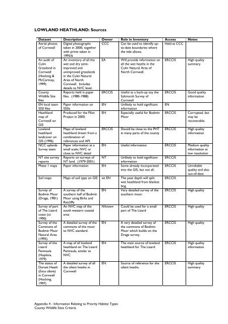
LOWLAND HEATHLAND: SourcesDataset Description Owner Role in Inventory Access NotesAerial photosCCCHeld at CCCof <strong>Cornwall</strong>An audit ofCulmGrassland in<strong>Cornwall</strong>(Hocking &McCartney,1999)<strong>County</strong>Wildlife <strong>Site</strong>filesEN local teamSSSI filesHeathlandmap of<strong>Cornwall</strong> onGISLowlandheathlandlandcover onGIS (1996)NCC uplandsSurvey teamDigital photographstaken in 2000, togetherwith prints taken in1995/6An inventory of all thewet and dry semiimprovedandunimproved grasslandsin the Culm NaturalArea of North<strong>Cornwall</strong>. Includesdetails to NVC level.Reports held in paperfiles. (1980-1988)Paper in<strong>for</strong>mation onSSSIsProduced <strong>for</strong> the PilotProject in 2000.Maps of lowlandheathland drawn from acombination ofreferences and API.Paper in<strong>for</strong>mation at asmall scale; NVC orclose to NVC detailReports on surveys ofEAERCCISENENERCCISCan be used to identify upto-dateboundaries wherethe tide allows.Will provide in<strong>for</strong>mation onall the wet heaths in theCulm Natural Area ofNorth <strong>Cornwall</strong>.Useful as a back-up toy theSaltmarsh Survey of<strong>Cornwall</strong>Unlikely to hold significantin<strong>for</strong>mationEspecially useful <strong>for</strong> BodminMoorShould be close to the PHTin many parts of the countyERCCISERCCISENERCCISERCCISHigh qualitysummaryGood qualityin<strong>for</strong>mationCorrupted, butmay berecoverable.High qualityin<strong>for</strong>mationEN Useful in<strong>for</strong>mation ERCCIS Medium qualityin<strong>for</strong>mation atlow resolutionNT Unlikely to hold significant ERCCISNT site surveyreports NT land. (1979-2001)in<strong>for</strong>mationPhase 1 maps Paper in<strong>for</strong>mation EN Some already incorporatedinto the GIS, but not all.Soil maps Maps of soil type on GIS via EN The peat depth will splitwet heathland from blanketbog.Survey ofBodmin Moor(Drage, 1981)Survey of partof The Lizardcoast (ca1990)Survey of theCommons ofBodmin MoorNatural Area(1995)Survey of theLizardPeninsula(Hopkins,1979)The status ofDorset Heath(Erica ciliaris)in <strong>Cornwall</strong>(Hocking,1997)A survey of thesouthern half of BodminMoor using Birks andRatcliffeAn NVC map of thesouth western coastalareaA detailed survey of thecommons of the moorto NVC standard.A map of all lowlandheathland on The LizardPeninsula, similar toNVCA detailed survey of allthe ciliaris heaths in<strong>Cornwall</strong>ENN/knownENENENVery detailed survey of thesouthern moor.Could be used <strong>for</strong> a smallpart of The LizardA very detailed survey ofthe commons of BodminMoor which builds on theDrage survey.The main source of lowlandheathland <strong>for</strong> The LizardSource of reference <strong>for</strong> theciliaris heaths.ERCCISERCCISERCCISERCCISERCCISERCCISERCCISUnreliablequality and alsoout-of-date.High qualityHigh qualityHigh qualityHigh qualityin<strong>for</strong>mationHigh qualitysummaryAppendix 4 - In<strong>for</strong>mation Relating to Priority Habitat Types<strong>County</strong> Wildlife <strong>Site</strong>s <strong>Criteria</strong>