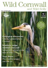
County Wildife Site Criteria for Cornwall Appendices
County Wildife Site Criteria for Cornwall Appendices
County Wildife Site Criteria for Cornwall Appendices

Create successful ePaper yourself
Turn your PDF publications into a flip-book with our unique Google optimized e-Paper software.
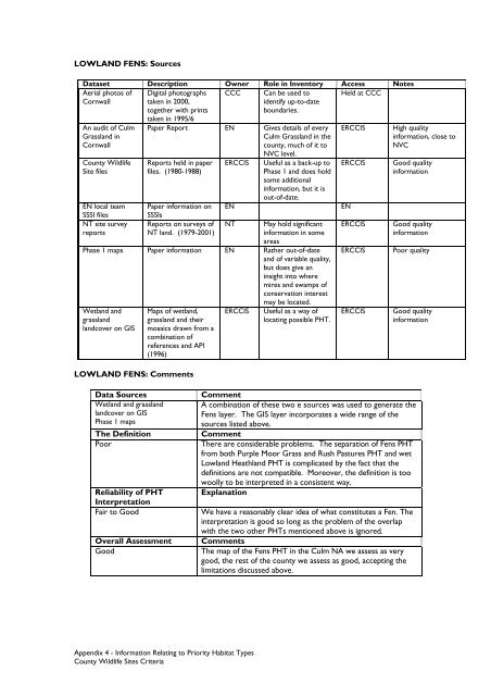
LOWLAND FENS: SourcesDataset Description Owner Role in Inventory Access NotesAerial photos ofCCCHeld at CCC<strong>Cornwall</strong>An audit of CulmGrassland in<strong>Cornwall</strong><strong>County</strong> Wildlife<strong>Site</strong> filesEN local teamSSSI filesNT site surveyreportsDigital photographstaken in 2000,together with printstaken in 1995/6Can be used toidentify up-to-dateboundaries.Paper Report EN Gives details of everyCulm Grassland in thecounty, much of it toNVC level.Reports held in paperfiles. (1980-1988)Paper in<strong>for</strong>mation onSSSIsReports on surveys ofNT land. (1979-2001)ERCCISENNTUseful as a back-up toPhase 1 and does holdsome additionalin<strong>for</strong>mation, but it isout-of-date.May hold significantin<strong>for</strong>mation in someareasPhase 1 maps Paper in<strong>for</strong>mation EN Rather out-of-dateand of variable quality,but does give aninsight into wheremires and swamps ofconservation interestmay be located.Wetland andgrasslandlandcover on GISMaps of wetland,grassland and theirmosaics drawn from acombination ofreferences and API(1996)LOWLAND FENS: CommentsERCCISUseful as a way oflocating possible PHT.ERCCISERCCISENERCCISERCCISERCCISHigh qualityin<strong>for</strong>mation, close toNVCGood qualityin<strong>for</strong>mationGood qualityin<strong>for</strong>mationPoor qualityGood qualityin<strong>for</strong>mationData SourcesWetland and grasslandlandcover on GISPhase 1 mapsThe DefinitionPoorReliability of PHTInterpretationFair to GoodOverall AssessmentGoodCommentA combination of these two e sources was used to generate theFens layer. The GIS layer incorporates a wide range of thesources listed above.CommentThere are considerable problems. The separation of Fens PHTfrom both Purple Moor Grass and Rush Pastures PHT and wetLowland Heathland PHT is complicated by the fact that thedefinitions are not compatible. Moreover, the definition is toowoolly to be interpreted in a consistent way.ExplanationWe have a reasonably clear idea of what constitutes a Fen. Theinterpretation is good so long as the problem of the overlapwith the two other PHTs mentioned above is ignored.CommentsThe map of the Fens PHT in the Culm NA we assess as verygood, the rest of the county we assess as good, accepting thelimitations discussed above.Appendix 4 - In<strong>for</strong>mation Relating to Priority Habitat Types<strong>County</strong> Wildlife <strong>Site</strong>s <strong>Criteria</strong>