County Wildife Site Criteria for Cornwall Appendices
County Wildife Site Criteria for Cornwall Appendices
County Wildife Site Criteria for Cornwall Appendices

You also want an ePaper? Increase the reach of your titles
YUMPU automatically turns print PDFs into web optimized ePapers that Google loves.
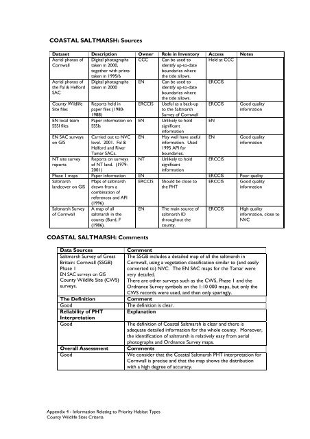
COASTAL SALTMARSH: SourcesDataset Description Owner Role in Inventory Access NotesAerial photos ofCCCHeld at CCC<strong>Cornwall</strong>Aerial photos ofthe Fal & Hel<strong>for</strong>dSAC<strong>County</strong> Wildlife<strong>Site</strong> filesEN local teamSSSI filesEN SAC surveyson GISNT site surveyreportsDigital photographstaken in 2000,together with printstaken in 1995/6Digital photographstaken in 2000Reports held inpaper files (1980-1988)Paper in<strong>for</strong>mation onSSSIsCarried out to NVClevel. 2001. Fal &Hel<strong>for</strong>d and RiverTamar SACs.Reports on surveysof NT land. (1979-2001)ENERCCISENENNTCan be used toidentify up-to-dateboundaries wherethe tide allows.Can be used toidentify up-to-dateboundaries wherethe tide allows.Useful as a back-upto the SaltmarshSurvey of <strong>Cornwall</strong>Unlikely to holdsignificantin<strong>for</strong>mationMay well have usefulin<strong>for</strong>mation. Used1995 API <strong>for</strong>boundaries.Unlikely to holdsignificantin<strong>for</strong>mationERCCISERCCISENENERCCISGood qualityin<strong>for</strong>mationGood qualityin<strong>for</strong>mationPhase 1 maps Paper in<strong>for</strong>mation EN ERCCIS Poor qualitySaltmarshlandcover on GISERCCIS Should be close tothe PHTERCCIS Good qualityin<strong>for</strong>mationSaltmarsh Surveyof <strong>Cornwall</strong>Maps of saltmarshdrawn from acombination ofreferences and API(1996)A map of allsaltmarsh in thecounty (Burd, F(1986).ENCOASTAL SALTMARSH: CommentsThe main source ofsaltmarsh IDthroughout thecounty.ERCCISHigh qualityin<strong>for</strong>mation, close toNVCData SourcesSaltmarsh Survey of GreatBritain: <strong>Cornwall</strong> (SSGB)Phase 1EN SAC surveys on GIS<strong>County</strong> Wildlife <strong>Site</strong> (CWS)surveys.The DefinitionGoodReliability of PHTInterpretationGoodOverall AssessmentGoodCommentThe SSGB includes a detailed map of all the saltmarsh in<strong>Cornwall</strong>, using a vegetation classification similar to (and easilyconverted to) NVC. The EN SAC maps <strong>for</strong> the Tamar werevery detailed.There are other surveys such as the CWS, Phase 1 and theOrdnance Survey symbols on the 1:10 000 maps, but only theCWS records were used, and then only sparingly.CommentThe definition is clear.ExplanationThe definition of Coastal Saltmarsh is clear and there isadequate detailed in<strong>for</strong>mation <strong>for</strong> the whole county. Moreover,the identification of saltmarsh is relatively easy from aerialphotographs and Ordnance Survey maps.CommentsWe consider that the Coastal Saltmarsh PHT interpretation <strong>for</strong><strong>Cornwall</strong> is precise and that the map shows the distributionwith a high degree of accuracy.Appendix 4 - In<strong>for</strong>mation Relating to Priority Habitat Types<strong>County</strong> Wildlife <strong>Site</strong>s <strong>Criteria</strong>