COM-1, pages 179-226 - ICOET
COM-1, pages 179-226 - ICOET
COM-1, pages 179-226 - ICOET

Create successful ePaper yourself
Turn your PDF publications into a flip-book with our unique Google optimized e-Paper software.
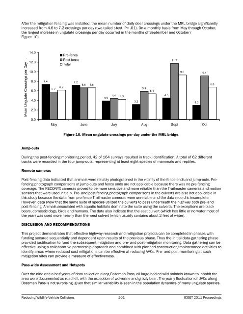
After the mitigation fencing was installed, the mean number of daily deer crossings under the MRL bridge significantlyincreased from 4.6 to 7.2 crossings per day (two-tailed t-test, P= .01). On a monthly basis from May through October,the largest increase in ungulate crossings per day occurred in the months of September and October (Figure 10).Mean Ungulate Crossings per Day .14.012.010.08.06.04.02.00.07.4 7.25.76.2Pre-fencePost-fenceTotal6.66.63.94.44.3May June July Aug Sept Oct3.25.95.44.511.79.33.09.16.8Figure 10. Mean ungulate crossings per day under the MRL bridge.Jump-outsDuring the post-fencing monitoring period, 42 of 164 surveys resulted in track identification. A total of 62 differenttracks were recorded in the four jump-outs, representing at least eight species of mammals and reptiles.Remote camerasPost-fencing data indicated that animals were reliably photographed in the vicinity of the fence ends and jump-outs. Prefencingphotograph comparisons at jump-outs and fence ends are not applicable because there was no pre-fencingcoverage. The RECONYX cameras proved to be more sensitive and more reliable than the Trailmaster cameras and motionsensors that were used initially. Pre- and post-fencing photograph comparisons in the culverts are also not applicable inthis study because the data from pre-fence Trailmaster cameras were unreliable and the data record is incomplete.However, data show that the same suite of species utilized the culverts to pass underneath the highway both pre- andpost-fencing. Animals associated with aquatic habitats dominate the suite using the culverts. The exceptions are blackbears, domestic dogs, birds and humans. The data also indicate that the east culvert (which has little or no water most ofthe year) was used more heavily than the west culvert (which usually contains about 2 feet of water).DISCUSSION AND RE<strong>COM</strong>MENDATIONSThis project demonstrates that effective highway research and mitigation projects can be completed in phases withfunding secured sequentially and dependent upon results of the previous phase. Thus the initial data-gathering phaseprovided justification to fund the subsequent mitigation and pre- and post-mitigation monitoring. Data gathering can beeffective using a collaborative partnership approach and combined with planned construction/maintenance activities toidentify areas where reduced cost mitigations can be effective at reducing AVCs. Pre- and post-monitoring at suchmitigation sites can provide a measure of effectiveness.Pass-wide Assessment and HotspotsOver the nine and a half years of data collection along Bozeman Pass, all large-bodied wild animals known to inhabit thearea were documented as road kill, with the exception of wolverine and grizzly bear. The yearly fluctuation of UVCs alongBozeman Pass is not surprising, given that similar variability is seen in the population dynamics of many ungulate species.Reducing Wildlife-Vehicle Collisions 201 <strong>ICOET</strong> 2011 Proceedings