Lake Water Quality 2006 Report - Lakefield Herald
Lake Water Quality 2006 Report - Lakefield Herald
Lake Water Quality 2006 Report - Lakefield Herald

Create successful ePaper yourself
Turn your PDF publications into a flip-book with our unique Google optimized e-Paper software.
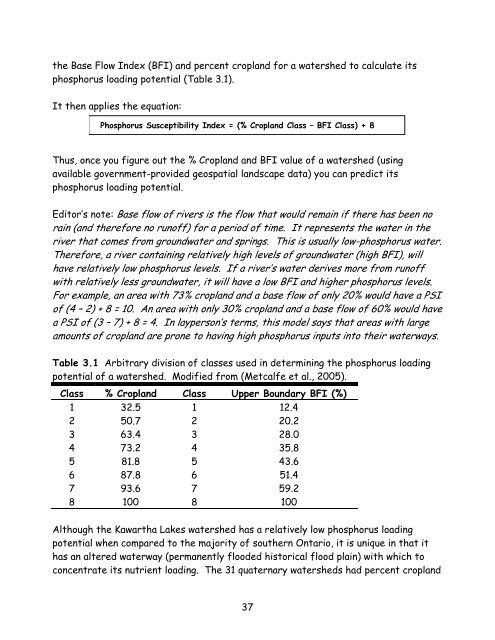
the Base Flow Index (BFI) and percent cropland for a watershed to calculate itsphosphorus loading potential (Table 3.1).It then applies the equation:Phosphorus Susceptibility Index = (% Cropland Class – BFI Class) + 8Thus, once you figure out the % Cropland and BFI value of a watershed (usingavailable government-provided geospatial landscape data) you can predict itsphosphorus loading potential.Editor’s note: Base flow of rivers is the flow that would remain if there has been norain (and therefore no runoff) for a period of time. It represents the water in theriver that comes from groundwater and springs. This is usually low-phosphorus water.Therefore, a river containing relatively high levels of groundwater (high BFI), willhave relatively low phosphorus levels. If a river’s water derives more from runoffwith relatively less groundwater, it will have a low BFI and higher phosphorus levels.For example, an area with 73% cropland and a base flow of only 20% would have a PSIof (4 – 2) + 8 = 10. An area with only 30% cropland and a base flow of 60% would havea PSI of (3 – 7) + 8 = 4. In layperson’s terms, this model says that areas with largeamounts of cropland are prone to having high phosphorus inputs into their waterways.Table 3.1 Arbitrary division of classes used in determining the phosphorus loadingpotential of a watershed. Modified from (Metcalfe et al., 2005).Class % Cropland Class Upper Boundary BFI (%)1 32.5 1 12.42 50.7 2 20.23 63.4 3 28.04 73.2 4 35.85 81.8 5 43.66 87.8 6 51.47 93.6 7 59.28 100 8 100Although the Kawartha <strong>Lake</strong>s watershed has a relatively low phosphorus loadingpotential when compared to the majority of southern Ontario, it is unique in that ithas an altered waterway (permanently flooded historical flood plain) with which toconcentrate its nutrient loading. The 31 quaternary watersheds had percent cropland37