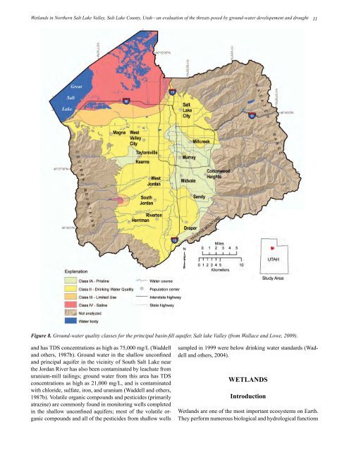
<strong>Wetlands</strong> <strong>in</strong> Northern <strong>Salt</strong> <strong>Lake</strong> <strong>Valley</strong>, <strong>Salt</strong> <strong>Lake</strong> <strong>County</strong>, <strong>Utah</strong>—an evaluation of the threats posed by ground-water developement and drought 11Figure 8. Ground-water quality classes for the pr<strong>in</strong>cipal bas<strong>in</strong>-fill aquifer, <strong>Salt</strong> lake <strong>Valley</strong> (from Wallace and Lowe, 2009).and has TDS concentrations as high as 75,000 mg/L (Waddelland others, 1987b). Ground water <strong>in</strong> the shallow unconf<strong>in</strong>edand pr<strong>in</strong>cipal aquifer <strong>in</strong> the vic<strong>in</strong>ity of South <strong>Salt</strong> <strong>Lake</strong> nearthe Jordan River has also been contam<strong>in</strong>ated by leachate fromuranium-mill tail<strong>in</strong>gs; ground water from this area has TDSconcentrations as high as 21,000 mg/L, and is contam<strong>in</strong>atedwith chloride, sulfate, iron, and uranium (Waddell and others,1987b). Volatile organic compounds and pesticides (primarilyatraz<strong>in</strong>e) are commonly found <strong>in</strong> monitor<strong>in</strong>g wells completed<strong>in</strong> the shallow unconf<strong>in</strong>ed aquifers; most of the volatile organiccompounds and all of the pesticides from shallow wellssampled <strong>in</strong> 1999 were below dr<strong>in</strong>k<strong>in</strong>g water standards (Waddelland others, 2004).WETLANDSIntroduction<strong>Wetlands</strong> are one of the most important ecosystems on Earth.They perform numerous biological and hydrological functions
12and are a valuable resource to communities. Wetland functions<strong>in</strong>clude wastewater treatment or water filtration, biogeochemicalcycl<strong>in</strong>g, floodwater control and storage, wildlifehabitat, biologic productivity, and food-cha<strong>in</strong> support; additionally,they have economic and cultural value (Lock, 1994)such as <strong>in</strong>creased residential property values.<strong>Wetlands</strong> are fac<strong>in</strong>g long-term impacts from both humanrelatedand natural causes. Human impacts are due to agricultural,<strong>in</strong>dustrial, and urban development and the result<strong>in</strong>gpollution. Natural impacts are generally due to climatologicalchanges. In the United States, an estimated 53% of wetlands<strong>in</strong> the lower 48 states have been destroyed s<strong>in</strong>ce the 1700sdue to human activities (Mitsch and Gossel<strong>in</strong>k, 2000). Agriculturalfields, commercial developments, and residentialdevelopments have typically replaced wetlands. Prior to themid-1970s, U.S. domestic policies encouraged the dra<strong>in</strong>ageof wetlands so that the land could be developed for economicbenefits. Now that the value and importance of wetlands havebeen recognized, conservation efforts have followed. The currentgoal of the U.S. government is to prevent net loss of wetlands,so when development of wetlands occurs, the amountof wetland area lost must be restored, created, or enhancedthrough the wetland mitigation process (U.S. Fish and WildlifeService, 1994). For additional <strong>in</strong>formation about wetlandsbackground, def<strong>in</strong>itions, and functions, refer to appendix A.<strong>Salt</strong> <strong>Lake</strong> <strong>County</strong> <strong>Wetlands</strong>Current National Wetland Inventory data (U.S. Fish andWildlife Service, 2010) show that 77% of wetlands <strong>in</strong> <strong>Utah</strong>are located with<strong>in</strong> 3 miles (5 km) of Great <strong>Salt</strong> <strong>Lake</strong>, whichcorresponds to an estimated 1.1 million acres (4450 km 2 ) ofwetlands. The <strong>Salt</strong> <strong>Lake</strong> <strong>County</strong> wetlands are mostly concentrated<strong>in</strong> the <strong>northern</strong> portion of the county along the shore ofGreat <strong>Salt</strong> <strong>Lake</strong> correspond<strong>in</strong>g to 49,300 acres (20,000 hm 2 ),or 84% with<strong>in</strong> 3 miles (5 km) of Great <strong>Salt</strong> <strong>Lake</strong>.Lock (1994) estimated that 30% of <strong>Utah</strong>’s wetlands has beenlost, mostly due to land-development practices. <strong>Salt</strong> <strong>Lake</strong><strong>County</strong> wetlands have been impacted by agricultural activities(<strong>in</strong>clud<strong>in</strong>g graz<strong>in</strong>g), <strong>in</strong>dustrial and urban development,and water diversions with ditches and dikes.N<strong>in</strong>ety-one percent of the wetlands are located <strong>in</strong> the pr<strong>in</strong>cipalaquifer ground-water discharge areas as determ<strong>in</strong>ed byAnderson and others (1994; figure 6), where there are one ormore conf<strong>in</strong>ed aquifers with an upward vertical flow gradientat depth and an overly<strong>in</strong>g shallow unconf<strong>in</strong>ed aquifer near theland surface. Much of the water supply for the wetlands isfrom the shallow unconf<strong>in</strong>ed aquifer. Thus, the elevation ofthe water table <strong>in</strong> the shallow unconf<strong>in</strong>ed aquifer partly determ<strong>in</strong>esthe areal extent of the wetlands. The shallow watertableelevation can also be controlled by surface water supplyto the wetlands, which varies with changes <strong>in</strong> recharge dueto climatic conditions and/or ground-water withdrawals fromwells and fluctuat<strong>in</strong>g Great <strong>Salt</strong> <strong>Lake</strong> levels.Wetland Types<strong>Utah</strong> Geological SurveyThe Emergency Wetland Resources Act of 1986 directs theU.S. Fish and Wildlife Service to map the wetlands of theUnited States; this mapp<strong>in</strong>g effort is referred to as the National<strong>Wetlands</strong> Inventory (NWI). <strong>Wetlands</strong> are typicallymapped us<strong>in</strong>g aerial photographs and are classified us<strong>in</strong>g theCoward<strong>in</strong> system. The Coward<strong>in</strong> system of wetland classification(Coward<strong>in</strong> and others, 1979) separates wetlands <strong>in</strong>tofive basic categories or systems: (1) lacustr<strong>in</strong>e, or lake-like,(2) river<strong>in</strong>e, or river, (3) palustr<strong>in</strong>e, or pond-like, (4) estuar<strong>in</strong>e,or estuary, and (5) mar<strong>in</strong>e, or oceanic. Once the wetlandshave been mapped and classified, any changes <strong>in</strong> their statusor trends can be monitored. NWI mapp<strong>in</strong>g for <strong>Salt</strong> <strong>Lake</strong><strong>County</strong> shows that the wetlands are dom<strong>in</strong>antly lacustr<strong>in</strong>e andpalustr<strong>in</strong>e with some river<strong>in</strong>e wetlands (figure 9, appendix B).Lacustr<strong>in</strong>e wetlands are associated with the shorel<strong>in</strong>e of Great<strong>Salt</strong> <strong>Lake</strong> as well as canals, ditches, and impoundments. Thepalustr<strong>in</strong>e wetlands are associated with spr<strong>in</strong>gs that dischargeground water.<strong>Salt</strong> <strong>Lake</strong> <strong>Valley</strong> wetlands occupy various types of habitats orenvironments. Except dur<strong>in</strong>g periods of extreme drought, thearea is largely permanently or periodically flooded lacustr<strong>in</strong>ewetland or open water (20,143 acres [8152 hm 2 ]) of Great <strong>Salt</strong><strong>Lake</strong>.From 2003 to 2008 much of this area was exposed as Great<strong>Salt</strong> <strong>Lake</strong> levels rema<strong>in</strong>ed near historic lows (figure 10).Other open-water environments are associated with sewagetreatmentponds and spr<strong>in</strong>g-fed ponds. The northwestern areaconsists of vegetated and non-vegetated m<strong>in</strong>eral and wet mudflats, transition<strong>in</strong>g to wet-meadow and emergent marsh environmentsto the northeastern border of the study area whereimpoundments have been built <strong>in</strong> the Farm<strong>in</strong>gton Bay WaterfowlManagement Area (FBWMA), private reserves, andhunt<strong>in</strong>g clubs.Orig<strong>in</strong>ally built <strong>in</strong> 1935 and occupy<strong>in</strong>g 3800 acres (1500 hm 2 ),the FBWMA has been expanded to over 12,000 acres (4900hm 2 ) <strong>in</strong> Davis and <strong>Salt</strong> <strong>Lake</strong> Counties and is managed by the<strong>Utah</strong> Division of Wildlife Resources (UDWR). As many as200 avian species have been documented us<strong>in</strong>g the wetlandsassociated with the FBWMA. The FBWMA wetlands providecritical year-round habitat for up to 57 species of waterfowland shorebirds, as many as 200,000 <strong>in</strong>dividuals, nest<strong>in</strong>g andforag<strong>in</strong>g <strong>in</strong> the spr<strong>in</strong>g and summer, and are also an importantstopover for millions of migrat<strong>in</strong>g waterfowl seasonally.The wetlands north of Interstate 80 are sourced by the JordanRiver, <strong>Salt</strong> <strong>Lake</strong> City Sewer Canal, Rudy Dra<strong>in</strong>, and Gogg<strong>in</strong>Dra<strong>in</strong> through a complex network of impoundments, canals,dikes, and various water-control structures (figure 11).Approximately 17,000 acres (6900 hm 2 ) of wetlands are dikedor impounded and are very precisely managed with waterdepths rang<strong>in</strong>g from 0 to 14 <strong>in</strong>ches (0–36 cm) to maximize waterfowlhabitat (<strong>Utah</strong> Division of Wildlife Resources, 2006).