

Wetlands in northern Salt Lake Valley, Salt Lake County, Utah
Wetlands in northern Salt Lake Valley, Salt Lake County, Utah
Wetlands in northern Salt Lake Valley, Salt Lake County, Utah

Create successful ePaper yourself
Turn your PDF publications into a flip-book with our unique Google optimized e-Paper software.
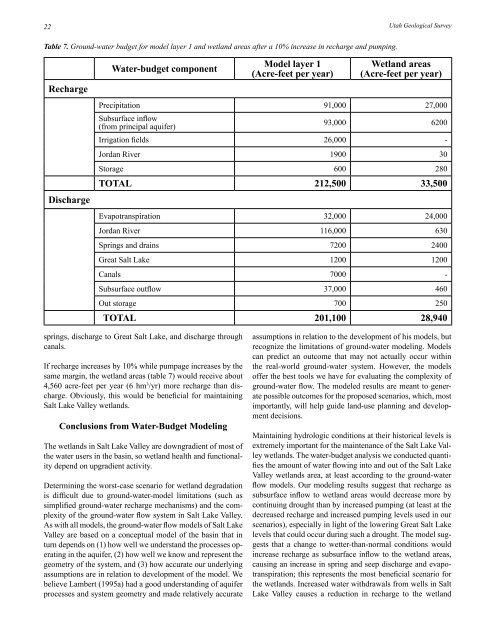
22<strong>Utah</strong> Geological SurveyTable 7. Ground-water budget for model layer 1 and wetland areas after a 10% <strong>in</strong>crease <strong>in</strong> recharge and pump<strong>in</strong>g.RechargeDischargeWater‐budget componentModel layer 1(Acre‐feet per year)Wetland areas(Acre‐feet per year)Precipitation 91,000 27,000Subsurface <strong>in</strong>flow(from pr<strong>in</strong>cipal aquifer)93,000 6200Irrigation fields 26,000 -Jordan River 1900 30Storage 600 280TOTAL 212,500 33,500Evapotranspiration 32,000 24,000Jordan River 116,000 630Spr<strong>in</strong>gs and dra<strong>in</strong>s 7200 2400Great <strong>Salt</strong> <strong>Lake</strong> 1200 1200Canals 7000 -Subsurface outflow 37,000 460Out storage 700 250TOTAL 201,100 28,940spr<strong>in</strong>gs, discharge to Great <strong>Salt</strong> <strong>Lake</strong>, and discharge throughcanals.If recharge <strong>in</strong>creases by 10% while pumpage <strong>in</strong>creases by thesame marg<strong>in</strong>, the wetland areas (table 7) would receive about4,560 acre-feet per year (6 hm 3 /yr) more recharge than discharge.Obviously, this would be beneficial for ma<strong>in</strong>ta<strong>in</strong><strong>in</strong>g<strong>Salt</strong> <strong>Lake</strong> <strong>Valley</strong> wetlands.Conclusions from Water‐Budget Model<strong>in</strong>gThe wetlands <strong>in</strong> <strong>Salt</strong> <strong>Lake</strong> <strong>Valley</strong> are downgradient of most ofthe water users <strong>in</strong> the bas<strong>in</strong>, so wetland health and functionalitydepend on upgradient activity.Determ<strong>in</strong><strong>in</strong>g the worst-case scenario for wetland degradationis difficult due to ground-water-model limitations (such assimplified ground-water recharge mechanisms) and the complexityof the ground-water flow system <strong>in</strong> <strong>Salt</strong> <strong>Lake</strong> <strong>Valley</strong>.As with all models, the ground-water flow models of <strong>Salt</strong> <strong>Lake</strong><strong>Valley</strong> are based on a conceptual model of the bas<strong>in</strong> that <strong>in</strong>turn depends on (1) how well we understand the processes operat<strong>in</strong>g<strong>in</strong> the aquifer, (2) how well we know and represent thegeometry of the system, and (3) how accurate our underly<strong>in</strong>gassumptions are <strong>in</strong> relation to development of the model. Webelieve Lambert (1995a) had a good understand<strong>in</strong>g of aquiferprocesses and system geometry and made relatively accurateassumptions <strong>in</strong> relation to the development of his models, butrecognize the limitations of ground-water model<strong>in</strong>g. Modelscan predict an outcome that may not actually occur with<strong>in</strong>the real-world ground-water system. However, the modelsoffer the best tools we have for evaluat<strong>in</strong>g the complexity ofground-water flow. The modeled results are meant to generatepossible outcomes for the proposed scenarios, which, mostimportantly, will help guide land-use plann<strong>in</strong>g and developmentdecisions.Ma<strong>in</strong>ta<strong>in</strong><strong>in</strong>g hydrologic conditions at their historical levels isextremely important for the ma<strong>in</strong>tenance of the <strong>Salt</strong> <strong>Lake</strong> <strong>Valley</strong>wetlands. The water-budget analysis we conducted quantifiesthe amount of water flow<strong>in</strong>g <strong>in</strong>to and out of the <strong>Salt</strong> <strong>Lake</strong><strong>Valley</strong> wetlands area, at least accord<strong>in</strong>g to the ground-waterflow models. Our model<strong>in</strong>g results suggest that recharge assubsurface <strong>in</strong>flow to wetland areas would decrease more bycont<strong>in</strong>u<strong>in</strong>g drought than by <strong>in</strong>creased pump<strong>in</strong>g (at least at thedecreased recharge and <strong>in</strong>creased pump<strong>in</strong>g levels used <strong>in</strong> ourscenarios), especially <strong>in</strong> light of the lower<strong>in</strong>g Great <strong>Salt</strong> <strong>Lake</strong>levels that could occur dur<strong>in</strong>g such a drought. The model suggeststhat a change to wetter-than-normal conditions would<strong>in</strong>crease recharge as subsurface <strong>in</strong>flow to the wetland areas,caus<strong>in</strong>g an <strong>in</strong>crease <strong>in</strong> spr<strong>in</strong>g and seep discharge and evapotranspiration;this represents the most beneficial scenario forthe wetlands. Increased water withdrawals from wells <strong>in</strong> <strong>Salt</strong><strong>Lake</strong> <strong>Valley</strong> causes a reduction <strong>in</strong> recharge to the wetland


