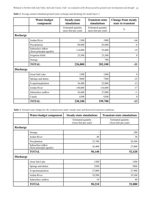
<strong>Wetlands</strong> <strong>in</strong> Northern <strong>Salt</strong> <strong>Lake</strong> <strong>Valley</strong>, <strong>Salt</strong> <strong>Lake</strong> <strong>County</strong>, <strong>Utah</strong>—an evaluation of the threats posed by ground-water developement and drought 19Table 2. Average annual simulated ground-water recharge and discharge for model layer 1.Water‐budgetcomponentSteady‐statesimulationsTransient‐statesimulationsChange from steadystate to transientEstimated quantity(acre-feet per year)Estimated quantity(acre-feet per year)%RechargeJordan River 1300 1900 +46Precipitation 88,000 83,000 -6Subsurface <strong>in</strong>flow(from pr<strong>in</strong>cipal aquifer)114,000 93,000 -19Irrigation fields 23,500 23,500 0Storage - 700 -TOTAL 226,800 202,100 ‐11DischargeGreat <strong>Salt</strong> <strong>Lake</strong> 1200 1200 0Spr<strong>in</strong>gs and dra<strong>in</strong>s 9600 7200 -25Evapotranspiration 36,400 32,000 -12Jordan River 140,000 116,000 -17Subsurface outflow 36,600 37,000 +1Canals 6300 6300 0TOTAL 230,100 199,700 ‐13Table 3. Ground-water budget for the wetland areas under steady-state and historical transient conditions.Water‐budget component Steady‐state simulations Transient‐state simulationsEstimated quantity(Acre-feet per year)Estimated quantity(Acre-feet per year)RechargeStorage - 290Jordan River 40 30Precipitation 23,700 24,300Subsurface <strong>in</strong>flow(from pr<strong>in</strong>cipal aquifer)26,400 27,800TOTAL 50,140 52,420DischargeGreat <strong>Salt</strong> <strong>Lake</strong> 1200 1200Spr<strong>in</strong>gs and dra<strong>in</strong>s 3500 3800Evapotranspiration 27,000 27,900Jordan River 18,500 19,100Subsurface outflow 10 80TOTAL 50,210 52,080
20<strong>Utah</strong> Geological SurveyTable 4. Ground-water budget for model layer 1and wetland areas after a 10% drop <strong>in</strong> recharge for 10 stress periods.Water‐budget componentModel layer 1(Acre‐feet per year)Wetland areas(Acre‐feet per year)RechargePrecipitation 75,000 24,100Subsurface <strong>in</strong>flow(from pr<strong>in</strong>cipal aquifer)93,000 14,500Irrigation fields 21,200 -Jordan River 1900 30DischargeStorage 77,700 280TOTAL 268,800 38,910Evapotranspiration 32,400 24,940Jordan River 116,200 10,150Spr<strong>in</strong>gs and dra<strong>in</strong>s 7200 2420Great <strong>Salt</strong> <strong>Lake</strong> 1200 1180Canals 6400 -Subsurface outflow 36,600 650Out storage 77,800 270TOTAL 277,800 39,610The wetland areas (table 5) would receive a total of 42,410acre-feet per year (50 hm 3 /yr) <strong>in</strong> recharge, and discharge atotal of 42,420 acre-feet per year (50 hm 3 /yr). A 10% <strong>in</strong>crease<strong>in</strong> pump<strong>in</strong>g at historical recharge rates will reduce evapotranspiration.Scenario 3 – Increased Pump<strong>in</strong>g and DecreasedRechargeA decrease <strong>in</strong> recharge by 10% with an <strong>in</strong>crease <strong>in</strong> pumpagefrom the pr<strong>in</strong>cipal aquifer by 10% would result <strong>in</strong> a deficitof about 19,000 acre-feet per year (23 hm 3 /yr) <strong>in</strong> the groundwaterbudget for model layer 1. Both recharge and dischargeare lower than the scenario under which there is a 10% decrease<strong>in</strong> recharge but pump<strong>in</strong>g rema<strong>in</strong>s the same (table 4),and the deficit <strong>in</strong> the ground-water budget is about doubled.The ground-water budget components under this scenario aresummarized <strong>in</strong> table 6.For the wetlands areas under this scenario (table 6), theground-water budget is expected to be <strong>in</strong> deficit by about1.5%. Evapotranspiration would decrease from its historicaltransient level of 27,900 acre-feet per year (34 hm 3 /yr) toabout 17,000 acre-feet per year (21 hm 3 /yr). About 3500 acrefeetper year (4 hm 3 /yr) of ground water would be dischargedthrough spr<strong>in</strong>gs and dra<strong>in</strong>s. This figure is lower comparedto the 3800 acre-feet per year (5 hm 3 /yr) discharged throughspr<strong>in</strong>gs and dra<strong>in</strong>s dur<strong>in</strong>g the last stress period of the historicaltransient simulation. Ground-water outflow to Great <strong>Salt</strong><strong>Lake</strong> would rema<strong>in</strong> the same at 1200 acre-feet per year (1.5hm 3 /yr), while subsurface outflow would drastically fall from80 acre-feet per year (0.1 hm 3 /yr) at the end the historicaltransient simulation to about 10 acre-feet per year (0.01 hm 3 /yr). The comb<strong>in</strong>ed effect of <strong>in</strong>creased pump<strong>in</strong>g and reducedrecharge would thus pose the most damag<strong>in</strong>g effect on theconditions of the wetlands <strong>in</strong> the area.Scenario 4 – Increased Recharge with Increas<strong>in</strong>gPumpageWith both pumpage and recharge <strong>in</strong>creased by 10%, theground-water budget for model layer 1 <strong>in</strong>dicates a surplus ofabout 11,000 acre-feet per year (14 hm 3 /yr) (table 7). In termsof wetlands hydrology, this is the best (most beneficial to wetlandshealth) of the scenarios we chose to model as part of thisstudy. Recharge from precipitation and subsurface rechargeboth <strong>in</strong>crease with respect to the historical and steady-statevalues. Model layer 1 has no pump<strong>in</strong>g wells completed with<strong>in</strong>it, and the pr<strong>in</strong>cipal sources of discharge are evapotranspiration,subsurface discharge, discharge through dra<strong>in</strong>s and