

Storm Data and Unusual Weather Phenomena - CIG
Storm Data and Unusual Weather Phenomena - CIG
Storm Data and Unusual Weather Phenomena - CIG

Create successful ePaper yourself
Turn your PDF publications into a flip-book with our unique Google optimized e-Paper software.
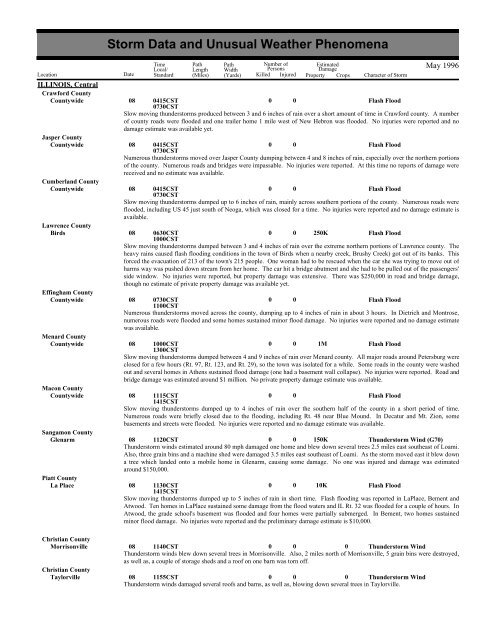
ILLINOIS, CentralCrawford CountyCountywideJasper CountyCountywideCumberl<strong>and</strong> CountyCountywideLawrence CountyBirdsEffingham CountyCountywideMenard CountyCountywideMacon CountyCountywideSangamon CountyGlenarmPiatt CountyLa Place<strong>Storm</strong> <strong>Data</strong> <strong>and</strong> <strong>Unusual</strong> <strong>Weather</strong> <strong>Phenomena</strong>Time Path PathNumber ofEstimatedLocal/ Length WidthPersonsDamageLocation Date St<strong>and</strong>ard (Miles) (Yards) Killed Injured Property Crops Character of <strong>Storm</strong>May 199608 0415CST0 0Flash Flood0730CSTSlow moving thunderstorms produced between 3 <strong>and</strong> 6 inches of rain over a short amount of time in Crawford county. A numberof county roads were flooded <strong>and</strong> one trailer home 1 mile west of New Hebron was flooded. No injuries were reported <strong>and</strong> nodamage estimate was available yet.08 0415CST0 0Flash Flood0730CSTNumerous thunderstorms moved over Jasper County dumping between 4 <strong>and</strong> 8 inches of rain, especially over the northern portionsof the county. Numerous roads <strong>and</strong> bridges were impassable. No injuries were reported. At this time no reports of damage werereceived <strong>and</strong> no estimate was available.08 0415CST0 0Flash Flood0730CSTSlow moving thunderstorms dumped up to 6 inches of rain, mainly across southern portions of the county. Numerous roads wereflooded, including US 45 just south of Neoga, which was closed for a time. No injuries were reported <strong>and</strong> no damage estimate isavailable.08 0630CST0 0 250KFlash Flood1000CSTSlow moving thunderstorms dumped between 3 <strong>and</strong> 4 inches of rain over the extreme northern portions of Lawrence county. Theheavy rains caused flash flooding conditions in the town of Birds when a nearby creek, Brushy Creek) got out of its banks. Thisforced the evacuation of 213 of the town's 215 people. One woman had to be rescued when the car she was trying to move out ofharms way was pushed down stream from her home. The car hit a bridge abutment <strong>and</strong> she had to be pulled out of the passengers'side window. No injuries were reported, but property damage was extensive. There was $250,000 in road <strong>and</strong> bridge damage,though no estimate of private property damage was available yet.08 0730CST0 0Flash Flood1100CSTNumerous thunderstorms moved across the county, dumping up to 4 inches of rain in about 3 hours. In Dietrich <strong>and</strong> Montrose,numerous roads were flooded <strong>and</strong> some homes sustained minor flood damage. No injuries were reported <strong>and</strong> no damage estimatewas available.08 1000CST0 0 1MFlash Flood1300CSTSlow moving thunderstorms dumped between 4 <strong>and</strong> 9 inches of rain over Menard county. All major roads around Petersburg wereclosed for a few hours (Rt. 97, Rt. 123, <strong>and</strong> Rt. 29), so the town was isolated for a while. Some roads in the county were washedout <strong>and</strong> several homes in Athens sustained flood damage (one had a basement wall collapse). No injuries were reported. Road <strong>and</strong>bridge damage was estimated around $1 million. No private property damage estimate was available.08 1115CST0 0Flash Flood1415CSTSlow moving thunderstorms dumped up to 4 inches of rain over the southern half of the county in a short period of time.Numerous roads were briefly closed due to the flooding, including Rt. 48 near Blue Mound. In Decatur <strong>and</strong> Mt. Zion, somebasements <strong>and</strong> streets were flooded. No injuries were reported <strong>and</strong> no damage estimate was available.08 1120CST0 0 150KThunderstorm Wind (G70)Thunderstorm winds estimated around 80 mph damaged one home <strong>and</strong> blew down several trees 2.5 miles east southeast of Loami.Also, three grain bins <strong>and</strong> a machine shed were damaged 3.5 miles east southeast of Loami. As the storm moved east it blew downa tree which l<strong>and</strong>ed onto a mobile home in Glenarm, causing some damage. No one was injured <strong>and</strong> damage was estimatedaround $150,000.08 1130CST0 0 10KFlash Flood1415CSTSlow moving thunderstorms dumped up to 5 inches of rain in short time. Flash flooding was reported in LaPlace, Bement <strong>and</strong>Atwood. Ten homes in LaPlace sustained some damage from the flood waters <strong>and</strong> IL Rt. 32 was flooded for a couple of hours. InAtwood, the grade school's basement was flooded <strong>and</strong> four homes were partially submerged. In Bement, two homes sustainedminor flood damage. No injuries were reported <strong>and</strong> the preliminary damage estimate is $10,000.Christian CountyMorrisonville 08 1140CST0 00 Thunderstorm WindThunderstorm winds blew down several trees in Morrisonville. Also, 2 miles north of Morrisonville, 5 grain bins were destroyed,as well as, a couple of storage sheds <strong>and</strong> a roof on one barn was torn off.Christian CountyTaylorville 08 1155CST0 00 Thunderstorm WindThunderstorm winds damaged several roofs <strong>and</strong> barns, as well as, blowing down several trees in Taylorville.


