

Storm Data and Unusual Weather Phenomena - CIG
Storm Data and Unusual Weather Phenomena - CIG
Storm Data and Unusual Weather Phenomena - CIG

You also want an ePaper? Increase the reach of your titles
YUMPU automatically turns print PDFs into web optimized ePapers that Google loves.
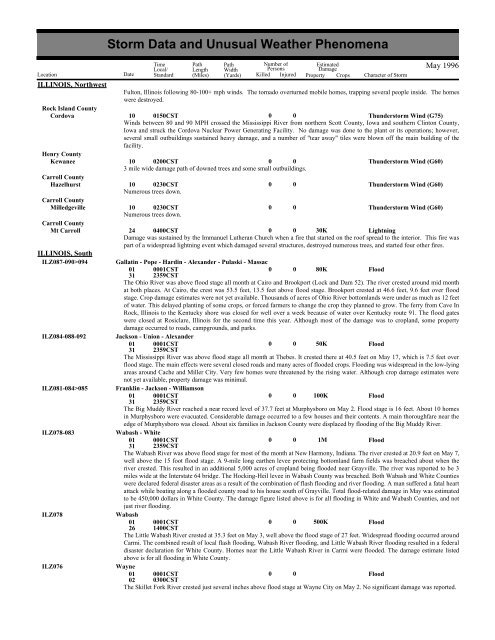
ILLINOIS, NorthwestRock Isl<strong>and</strong> CountyCordovaHenry CountyKewaneeCarroll CountyHazelhurstCarroll CountyMilledgevilleCarroll CountyMt CarrollILLINOIS, SouthILZ087-090>094ILZ084-088-092ILZ081-084>085ILZ078-083ILZ078ILZ076<strong>Storm</strong> <strong>Data</strong> <strong>and</strong> <strong>Unusual</strong> <strong>Weather</strong> <strong>Phenomena</strong>Time Path PathNumber ofEstimatedLocal/ Length WidthPersonsDamageLocation Date St<strong>and</strong>ard (Miles) (Yards) Killed Injured Property Crops Character of <strong>Storm</strong>Fulton, Illinois following 80-100+ mph winds. The tornado overturned mobile homes, trapping several people inside. The homeswere destroyed.10 0150CST0 0Thunderstorm Wind (G75)Winds between 80 <strong>and</strong> 90 MPH crossed the Mississippi River from northern Scott County, Iowa <strong>and</strong> southern Clinton County,Iowa <strong>and</strong> struck the Cordova Nuclear Power Generating Facility. No damage was done to the plant or its operations; however,several small outbuildings sustained heavy damage, <strong>and</strong> a number of "tear away" tiles were blown off the main building of thefacility.10 0200CST0 03 mile wide damage path of downed trees <strong>and</strong> some small outbuildings.10 0230CSTNumerous trees down.10 0230CSTNumerous trees down.0000May 1996Thunderstorm Wind (G60)Thunderstorm Wind (G60)Thunderstorm Wind (G60)24 0400CST0 0 30KLightningDamage was sustained by the Immanuel Lutheran Church when a fire that started on the roof spread to the interior. This fire waspart of a widespread lightning event which damaged several structures, destroyed numerous trees, <strong>and</strong> started four other fires.Gallatin - Pope - Hardin - Alex<strong>and</strong>er - Pulaski - Massac01 0001CST0 0 80KFlood31 2359CSTThe Ohio River was above flood stage all month at Cairo <strong>and</strong> Brookport (Lock <strong>and</strong> Dam 52). The river crested around mid monthat both places. At Cairo, the crest was 53.5 feet, 13.5 feet above flood stage. Brookport crested at 46.6 feet, 9.6 feet over floodstage. Crop damage estimates were not yet available. Thous<strong>and</strong>s of acres of Ohio River bottoml<strong>and</strong>s were under as much as 12 feetof water. This delayed planting of some crops, or forced farmers to change the crop they planned to grow. The ferry from Cave InRock, Illinois to the Kentucky shore was closed for well over a week because of water over Kentucky route 91. The flood gateswere closed at Rosiclare, Illinois for the second time this year. Although most of the damage was to cropl<strong>and</strong>, some propertydamage occurred to roads, campgrounds, <strong>and</strong> parks.Jackson - Union - Alex<strong>and</strong>er01 0001CST0 0 50KFlood31 2359CSTThe Mississippi River was above flood stage all month at Thebes. It crested there at 40.5 feet on May 17, which is 7.5 feet overflood stage. The main effects were several closed roads <strong>and</strong> many acres of flooded crops. Flooding was widespread in the low-lyingareas around Cache <strong>and</strong> Miller City. Very few homes were threatened by the rising water. Although crop damage estimates werenot yet available, property damage was minimal.Franklin - Jackson - Williamson01 0001CST0 0 100KFlood31 2359CSTThe Big Muddy River reached a near record level of 37.7 feet at Murphysboro on May 2. Flood stage is 16 feet. About 10 homesin Murphysboro were evacuated. Considerable damage occurred to a few houses <strong>and</strong> their contents. A main thoroughfare near theedge of Murphysboro was closed. About six families in Jackson County were displaced by flooding of the Big Muddy River.Wabash - White01 0001CST0 0 1MFlood31 2359CSTThe Wabash River was above flood stage for most of the month at New Harmony, Indiana. The river crested at 20.9 feet on May 7,well above the 15 foot flood stage. A 9-mile long earthen levee protecting bottoml<strong>and</strong> farm fields was breached about when theriver crested. This resulted in an additional 5,000 acres of cropl<strong>and</strong> being flooded near Grayville. The river was reported to be 3miles wide at the Interstate 64 bridge. The Hocking-Heil levee in Wabash County was breached. Both Wabash <strong>and</strong> White Countieswere declared federal disaster areas as a result of the combination of flash flooding <strong>and</strong> river flooding. A man suffered a fatal heartattack while boating along a flooded county road to his house south of Grayville. Total flood-related damage in May was estimatedto be 450,000 dollars in White County. The damage figure listed above is for all flooding in White <strong>and</strong> Wabash Counties, <strong>and</strong> notjust river flooding.Wabash01 0001CST0 0 500KFlood26 1400CSTThe Little Wabash River crested at 35.3 feet on May 3, well above the flood stage of 27 feet. Widespread flooding occurred aroundCarmi. The combined result of local flash flooding, Wabash River flooding, <strong>and</strong> Little Wabash River flooding resulted in a federaldisaster declaration for White County. Homes near the Little Wabash River in Carmi were flooded. The damage estimate listedabove is for all flooding in White County.Wayne01 0001CST0 0Flood02 0300CSTThe Skillet Fork River crested just several inches above flood stage at Wayne City on May 2. No significant damage was reported.


