Steer Davies Gleave New media design
Steer Davies Gleave New media design
Steer Davies Gleave New media design

You also want an ePaper? Increase the reach of your titles
YUMPU automatically turns print PDFs into web optimized ePapers that Google loves.
Baldw<br />
ad<br />
Road<br />
Coldharb<br />
Road<br />
Alderton Road<br />
Knatchbull Road<br />
Mcdowall Road<br />
Geoffrey Close<br />
Harbour Road<br />
Herne Hill Road<br />
County Grove<br />
4<br />
Vaughan Road<br />
Bengeworth Rd<br />
Comber Grove<br />
Southwell Road<br />
35, 45<br />
345<br />
35, 45<br />
345<br />
Cambria Road<br />
Southwark City Council<br />
Camberwell<br />
Local area map, pocket guide<br />
and interactive map.<br />
Oval<br />
(15 mins)<br />
36<br />
185<br />
436<br />
1 9<br />
B<br />
C<br />
D<br />
E<br />
F<br />
G<br />
Kenbury Street<br />
H<br />
Brixton<br />
(20 mins)<br />
J<br />
K<br />
Walk continues overleaf<br />
Walk continues overleaf<br />
Denmark Road<br />
Kemerton Road<br />
1<br />
Medlar Street<br />
Games<br />
Court<br />
Northway Road<br />
Camberwell Station Road<br />
Bicknell Road<br />
Station Terrace<br />
Warner Road<br />
Lowth Road<br />
This mapping is based upon<br />
Ordnance Survey material with<br />
the permission of the Controller<br />
of Her Majesty’s Stationery<br />
Office. © Crown Copyright.<br />
Unauthorised reproduction<br />
infringes crown copyright and<br />
may lead to prosecution or civil<br />
proceedings. London Borough<br />
of Southwark, (0)100019252.<br />
1<br />
W<br />
N<br />
S<br />
E<br />
Camberwell <strong>New</strong> Road<br />
Crawford Road<br />
Coldharbour Lane<br />
Cutcombe Road<br />
5 mins<br />
King’s College London<br />
Weston Education Centre<br />
Finsen Road<br />
2<br />
2<br />
35, 45<br />
345<br />
Valmar Road<br />
Bavent Road<br />
Elephant & Castle<br />
(35 mins)<br />
36<br />
185<br />
436<br />
Morna Road<br />
Venetian Road<br />
F<br />
36<br />
185<br />
436<br />
Camberwell<br />
Caldecot Road<br />
Bessemer Road<br />
3<br />
Passage<br />
Tennis Courts<br />
Milkwell Yd<br />
Coldharbour Pl<br />
Camberwell Road<br />
35, 40<br />
42, 45<br />
6<br />
35<br />
45<br />
345<br />
35, 45<br />
345<br />
12, 148<br />
171, 176<br />
468, 68<br />
Denmark Hill<br />
8<br />
35, 40<br />
42, 45<br />
40<br />
176<br />
185<br />
484<br />
68<br />
148 35<br />
176 42<br />
185 45<br />
468 68<br />
345<br />
468<br />
345<br />
4<br />
Camberwell<br />
Green<br />
Butterfly Walk<br />
Shopping<br />
arcade<br />
Joiners Arms Yd<br />
Selborne Rd<br />
40, 42<br />
68, 176<br />
185, 468<br />
40<br />
42<br />
68<br />
176<br />
185<br />
468<br />
484<br />
40, 42<br />
68, 176<br />
185, 468<br />
484<br />
King’s College Hospital<br />
4<br />
Camberwell<br />
Ferndene Road<br />
7<br />
Camberwell Green<br />
Orpheus Street<br />
Love Walk<br />
42, 68, 468<br />
1<br />
12, 36<br />
171, 345<br />
436<br />
Wren Road<br />
A&E<br />
Acland Crescent<br />
D’eynsford Road<br />
Ruskin<br />
Park<br />
Bowling<br />
Green<br />
5<br />
Camberwell<br />
Magistrates’<br />
Court<br />
12, 36<br />
171, 345<br />
436<br />
Allendale Close<br />
Harbord Cl.<br />
local area map<br />
Elmington Rd<br />
Harvey Road<br />
Daneville Road<br />
40, 176<br />
185, 484<br />
Welcome to the<br />
5<br />
Camberwell<br />
Leisure<br />
Centre<br />
Police<br />
Station<br />
Evesham<br />
Walk<br />
Jephson Street<br />
6<br />
Walk continues overleaf<br />
Artichoke<br />
Place<br />
Maudsley<br />
Hospital<br />
Sundial<br />
Kimpton Road<br />
42, 68, 468<br />
Camberwell Church Street<br />
1<br />
Kerfield Crescent<br />
Don Phelan Close<br />
De Crespigny Park<br />
Denmark Hill<br />
Kerfield Place<br />
40<br />
176<br />
484<br />
Camberwell local area map<br />
Walk continues overleaf<br />
On this map you will find an abundance of<br />
interesting and useful information about<br />
Camberwell and the surrounding area.<br />
6<br />
Love Walk<br />
The<br />
Oval<br />
Datchelor Pl<br />
Mary Datchelor Close<br />
Camberwell Grove<br />
Grove Lane<br />
King’s College<br />
London Institute<br />
of Psychiatry<br />
Denmark Hill<br />
Station<br />
Blanchedowne<br />
Clapham Rd<br />
Towards Clapham, Balham<br />
Wandsworth (50 mins)<br />
Camberwell is a place with a vivid history and a varied and<br />
fascinating community. Everything you need is right on<br />
your doorstep and this map should help you find it. Why<br />
not take some time to visit some of the sights and sounds<br />
Camberwell has to offer or explore a new street?<br />
Lovely Camberwell Green is well known, but the area<br />
also boasts a number of other attractive green spaces,<br />
including St Giles Churchyard, Sceaux Gardens and Ruskin<br />
Park. You can visit all of these through our nature walks.<br />
There are many local restaurants, pubs and cafes to<br />
suit all tastes and other facilities include a mix of classic<br />
high street shops and services, and interesting small<br />
independent businesses. With the art college nearby,<br />
the area has a booming arts culture, supporting three<br />
galleries, two theatres and a season of open studios and<br />
arts festivals throughout the year.<br />
Use this map to find what you need locally, then maybe<br />
walk or cycle to get there. Wherever you visit we hope you<br />
enjoy the experience and discover some of Camberwell’s<br />
hidden gems.<br />
For an interactive version of this map please visit:<br />
www.se5forum.org or www.camberwellrenewal.org.uk<br />
W<br />
N<br />
S<br />
E<br />
Oval<br />
Station<br />
Windsor Walk<br />
40<br />
176<br />
185<br />
484<br />
7<br />
Sansom Street<br />
3<br />
Kennington Park Road<br />
Brixton Road<br />
Champion Park<br />
100 metres<br />
Key to symbols on reverse<br />
Herne Hill<br />
(30 mins)<br />
Brixton<br />
Station<br />
Springhill Cl<br />
King’s College<br />
Hall<br />
Champion Hill<br />
Vicarage Grove<br />
Vicarage Grove<br />
St Giles<br />
Youth<br />
Centre<br />
Ribbon Dance Mews<br />
St Giles<br />
Church<br />
Kennington<br />
Station<br />
Kennington Park<br />
Vassel Road<br />
Mostyn<br />
Gardens<br />
Wiltshire Road<br />
Beaulieu Close<br />
3<br />
5<br />
8<br />
Benhill Road<br />
8<br />
Champion Hill<br />
Brunswick Park<br />
Camberwell Glebe<br />
Peckham<br />
(20 mins)<br />
Walk continues overleaf Walk continues overleaf<br />
Walk continues overleaf<br />
East Dulwich<br />
(15 mins)<br />
4<br />
3 7<br />
Wilson Road<br />
Grace’s Mews<br />
The Hamlet<br />
A<br />
B<br />
D<br />
KENNINGTON<br />
E<br />
F<br />
H<br />
Camberwell <strong>New</strong> Road<br />
I<br />
J<br />
K<br />
Champion Grove<br />
Coldharbour Lane<br />
BRIXTON<br />
Railton Road<br />
Cash Machine/ATM<br />
Bank<br />
Hotel<br />
Launderette<br />
Chemist<br />
Post Office<br />
College<br />
Supermarket<br />
Local Shop<br />
Cycle Shop<br />
Akerman Road<br />
Loughborough Road<br />
Myatt<br />
Fields<br />
Anderton Cl<br />
Blue Elephant<br />
Theatre<br />
SE5 AREA<br />
Wyck<br />
Gardens<br />
Loughborough Park<br />
John Ruskin Street<br />
4<br />
Loughborough<br />
Junction Station<br />
Shakespeare Road<br />
Milkwood Road<br />
Art Gallery/Studio<br />
Church<br />
Library<br />
Town Hall<br />
Theatre<br />
Tennis Courts<br />
Club<br />
Bar/Pub<br />
Restaurant<br />
Café<br />
Takeaway<br />
Towards Elephant & Castle (15mins)<br />
River Thames (40 mins)<br />
Camberwell Road<br />
6<br />
Area covered by<br />
map overleaf<br />
4<br />
Bowyer Place<br />
8<br />
7<br />
Denmark Hill<br />
7<br />
6<br />
CAMBERWELL<br />
Herne Hill Road<br />
Camberwell<br />
Green<br />
Ruskin Park<br />
Ferndene Road<br />
5<br />
3<br />
1<br />
1<br />
Edmund Street<br />
Camberwell Church Street<br />
Denmark Hill<br />
Station<br />
Denmark Hill<br />
Cycle Route<br />
Immigration Walk<br />
Wildlife Walk<br />
Bus Stop<br />
Underground Station<br />
Train Station<br />
Southwark<br />
College<br />
Brunswick<br />
Park<br />
3<br />
4<br />
Champion Pk<br />
7<br />
2<br />
Albany Road<br />
3<br />
Southampton Way<br />
Havil Street<br />
Grove Lane<br />
Towards Herne Hill<br />
(10 mins)<br />
2<br />
Hospital<br />
Public Car Park<br />
Playground<br />
Cycle Stands<br />
Public Toilets<br />
Burgess Park<br />
Camberwell<br />
College of Arts<br />
6<br />
5<br />
Lake<br />
St Georges Way<br />
Lucas<br />
Gardens<br />
Dog Kennel Hill<br />
2<br />
South London<br />
Gallery<br />
HOLBORN<br />
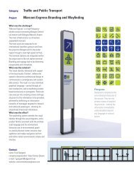
The London Borough of<br />
Southwark, commissioned <strong>Steer</strong><br />
<strong>Davies</strong> <strong>Gleave</strong> to <strong>design</strong> a map of<br />
the Camberwell area to promote<br />
increased walking and cycling.<br />
The map’s focus was on the<br />
Borough’s history and community,<br />
providing interesting and useful<br />
information about the area,<br />
its facilities and its services.<br />
The solution was applied to both<br />
print and online <strong>media</strong>.<br />
http://visuals.sdgworld.net/<br />
camberwell2/<br />
Trafalgar Ave<br />
East Dulwich<br />
Station<br />
East Dulwich Grove<br />
STOCKWELL<br />
W<br />
Old Kent Road<br />
Willowbrook Road Peckham Hill Street<br />
Sumner Road<br />
Peckham Road<br />
Warwick<br />
Gardens<br />
Bellenden Road<br />
Grove Vale<br />
Bellenden Road<br />
Peckham<br />
Pulse<br />
EAST DULWICH<br />
LAMBETH<br />
N<br />
S<br />
CITY OF<br />
LONDON<br />
SOUTHWARK<br />
Camberwell<br />
E<br />
PECKHAM<br />
W<br />
1<br />
N S<br />
Peckham High Street<br />
Towards Peckham (‹5 mins)<br />
Nunhead (20 mins)<br />
Walks<br />
E<br />
Peckham Rye<br />
This mapping is based upon<br />
Ordnance Survey material with<br />
the permission of the Controller<br />
of Her Majesty’s Stationery<br />
Office. © Crown Copyright.<br />
Unauthorised reproduction<br />
infringes crown copyright and<br />
may lead to prosecution or civil<br />
proceedings. London Borough<br />
of Southwark, (0)100019252.<br />
½ mile<br />
Camberwell wildlife<br />
1 km<br />
WHITECHAPEL<br />
POPLAR<br />
Walk A: Ruskin Park to Brunswick Park<br />
1 Ruskin Park: Unusual trees, a pond with moorhens,<br />
mallards and geese, views over London<br />
2 Canning Cross footpath: Between Sir George Canning<br />
pub and 142 and 144 Camberwell Grove<br />
3 Churchyard Passage<br />
4 St Giles Churchyard<br />
5 Lucas Gardens<br />
6 Footpath through ‘Voltaire’ block of flats to Sceaux Gardens<br />
7 Brunswick Park<br />
DOCKLANDS<br />
Walk B: Peckham to Camberwell Green via Burgess Park Lake<br />
1 Peckham Square: The leafy Surrey Canal walk follows<br />
the route of the old canal between Rotherhithe docks<br />
and Walworth Road<br />
2 Burgess Park: A large lake with diverse fish and wildfowl,<br />
and dozens of Sunday football games<br />
3 Chumleigh Gardens: Walled gardens with plants from<br />
all over the world<br />
4 Addington Square<br />
5 Caspian Street allotments<br />
6 Community Orchard: Fruit trees and bushes, rosemary<br />
GREENWICH<br />
and lavender<br />
7 Camberwell Green<br />
Early immigration to Camberwell<br />
1 Ruskin Park: While staying with the Benecke family<br />
in a house on Denmark Hill, Mendelssohn wrote<br />
‘Camberwell Green’, a ‘song without words’ for the piano.<br />
The piece (later renamed ‘Spring Song’) was used<br />
widely in silent films to accompany scenes showing a<br />
‘damsel in distress’. Wagner was another visitor.<br />
2 The Platanes, Champion Hill: The sole survivor of three<br />
grand mansions belonging to the Kleinworth merchant<br />
banking family. Now part of King’s College London.<br />
3 Love Walk: The old brick wall visible to the south is the<br />
boundary of the country estate of the De Crespigny<br />
family. They were French Protestants (known as<br />
Huguenots) who moved to England in<br />
1685 to escape persecution.<br />
4 Denmark Road: Karl Marx stayed here briefly with<br />
German friends when he first arrived in London.<br />
5 Minet library: In 1770, Hughes Minet, of Huguenot<br />
origin, bought this estate. In 1889, his philanthropic<br />
descendant, William Minet, donated the land to create<br />
Myatt’s Fields. Local street names such as Calais and<br />
Cormont Road mark the family’s origins.<br />
6 A plaque on the wall at 325 Camberwell <strong>New</strong> Road<br />
records that Otto Benecke helped to raise subscriptions to<br />
reopen a public dispensary here in 1880.<br />
Coordinated by SEA/Renue, www.sustainable-energy.org.uk<br />
Project partners: Camberwell Travel Plan Group<br />
Walks developed by: Eleanor Margolies<br />
Designed by <strong>Steer</strong> <strong>Davies</strong> <strong>Gleave</strong>, www.steerdaviesgleave.com<br />
Printed on 100% recycled paper, FSC certified.<br />
June 2007<br />
SE5F RUM<br />
FOR CAMBERWELL