Steer Davies Gleave New media design
Steer Davies Gleave New media design
Steer Davies Gleave New media design

Create successful ePaper yourself
Turn your PDF publications into a flip-book with our unique Google optimized e-Paper software.
<strong>Steer</strong> <strong>Davies</strong> <strong>Gleave</strong><br />
<strong>New</strong> <strong>media</strong> <strong>design</strong><br />
movement +<br />
environment + identity.
<strong>Steer</strong> <strong>Davies</strong> <strong>Gleave</strong><br />
Design<br />
Contact<br />
Phil Berczuk<br />
phil.berczuk@sdgworld.net<br />
+44 (0)20 7910 5000<br />
<strong>Steer</strong> <strong>Davies</strong> <strong>Gleave</strong><br />
28-32 Upper Ground<br />
London SE1 9PD<br />
United Kingdom
The core areas that define<br />
our practice are movement,<br />
environment and identity.<br />
Our work covers wayfinding,<br />
urban environments, information<br />
systems, brand strategy,<br />
consultation and communication.<br />
We combine human experience,<br />
perception and behavior to<br />
deliver real benefit to people<br />
in their daily lives.<br />
www.steerdaviesgleave.com
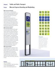
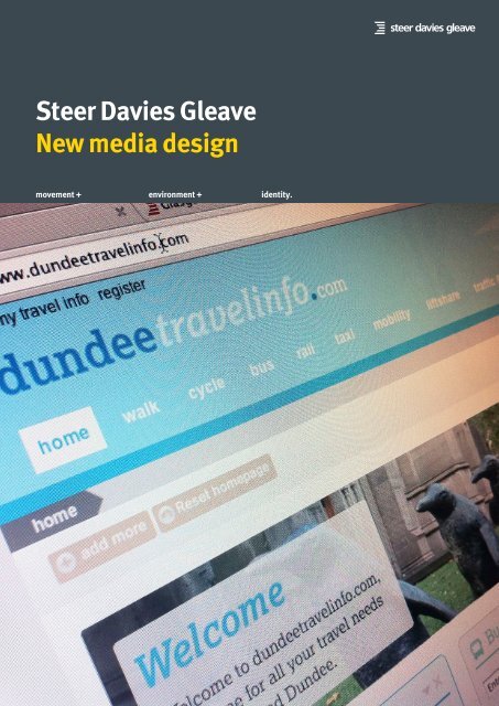
Public Transport<br />
Information System<br />
Dundee, Scotland<br />
Interactive mapping, journey<br />
planning, network mapping,<br />
at-stop information, stop flag,<br />
interactive kiosks, at stop<br />
audio, transport information<br />
portal, dynamic departure<br />
displays.<br />
Scottish Transport Award for<br />
Best Information - 2004<br />
Project partners<br />
RSL Kiosks<br />
TravelInfo Systems<br />
<strong>Steer</strong> <strong>Davies</strong> <strong>Gleave</strong> led<br />
the development, supply<br />
and install of a ground<br />
breaking package of public<br />
transport information and<br />
related hardware for the<br />
City of Dundee as part of the<br />
Scottish Transport award<br />
winning Bringing Confidence<br />
into Public Transport project<br />
(BCPT).
The Public Transport<br />
Information System (PTIS)<br />
forms the core of the BCPT<br />
project that includes bespoke<br />
shelter <strong>design</strong>s for city centre<br />
bus interchanges, dynamic bus<br />
departure displays, interactive<br />
on-street information kiosks<br />
with integrated interactive<br />
mapping and journey planning<br />
(also available through the<br />
internet), high quality printed<br />
information, city-wide real time<br />
information, mobile journey<br />
planning and departure<br />
information.<br />
The journey planner<br />
functionality was defined<br />
through comprehensive<br />
focus groups with the local<br />
population and <strong>design</strong>s were<br />
fine tuned through extensive<br />
local user testing. The vectorbased<br />
mapping delivered<br />
seamless and fully scalable<br />
exploration of the city. Bus<br />
stops or points of interest<br />
selected via the interactive<br />
map display information such<br />
as stop name , next three<br />
real time bus departures<br />
and stop facilities, allowing<br />
users direct access to real<br />
time information from their<br />
desktop. Information points<br />
on the interchange shelters<br />
are fitted with smart card<br />
triggered audio bus departure<br />
messages for local visually<br />
impaired users.<br />
A paper information strategy<br />
supports the online resources.<br />
A schematic map of the city’s<br />
bus network forms the basis<br />
of a comprehensive system<br />
of at-stop printed information<br />
implemented at all bus stops<br />
in Dundee.<br />
Dundee PTIS was awarded<br />
Best Information Project at<br />
the 2004 Scottish Transport<br />
Awards ceremony in Edinburgh<br />
and has since won a number<br />
of other prestigious national<br />
awards.<br />
www.dundeetravelinfo.com
en ols once that would they enable had engaged<br />
of interactive movies initiatives shot such by as local filmmakers<br />
th ct the on the project. information<br />
used to input journey origin and<br />
elopment of blogs, print competitions, and promoted advertising. and on-line digital and at other real The time site bus also arrivals, includes live, traffic<br />
they had engaged<br />
destination.<br />
is oject. rand was achieved and was movies shot<br />
through customer by local filmmakers touch points through disruption dynamic information and car parking feeds for<br />
promoted Practical on-line tools<br />
e creative development of print<br />
and include<br />
and<br />
at<br />
advertising.<br />
other a multi The site also includes<br />
real<br />
live,<br />
via multi-channel<br />
availability. time bus arrivals, traffic<br />
chieved through customer modal touch travel points information through portal. dynamic information feeds for<br />
e JourneyOn brand and was<br />
disruption and car parking<br />
e development of print and advertising. Practical tools include a multi<br />
yOn mmunicated brand and via was multi-channel The site provides a bespoke real time bus arrivals, traffic<br />
availability.<br />
Practical tools modal include travel a multi information disruption portal. and car parking<br />
ated via multi-channel<br />
modal travel The information site provides portal. a bespoke availability.<br />
Visit the site and experience the<br />
The site provides a bespoke Visit the site and experience project at www.journeyon.co.uk<br />
the<br />
project at www.journeyon.co.uk<br />
e<br />
l<br />
ed through<br />
Journey On<br />
Bristol & Hove City Council<br />
Website <strong>design</strong>, multimodal<br />
journey planner and<br />
Travelwise tool<br />
promotional campaigns, targeted<br />
local www.journeyon.co.uk<br />
events and the JourneyOn<br />
website, including a bespoke<br />
walk and cycle journey planner<br />
and carbon calculator www.<br />
journeyon.co.uk<br />
The campaigns included a range<br />
of interactive initiatives such as<br />
blogs, competitions, and digital<br />
movies shot by local filmmakers<br />
promoted on-line and at other<br />
customer touch points through<br />
print and advertising.<br />
Practical tools include a multi<br />
modal travel information portal.<br />
The site provides a bespoke<br />
walk and cycle planner that<br />
builds gradients into the route<br />
evaluation delivering local<br />
journey results tailored to<br />
peoples’ ability or fitness levels.<br />
Results from the journey planner<br />
are presented on a Google<br />
Maps interface that can be<br />
used to input journey origin and<br />
destination.<br />
The site also includes live,<br />
dynamic information feeds for<br />
real time bus arrivals, traffic<br />
disruption and car parking<br />
availability.<br />
Visit the site and experience the<br />
project at www.journeyon.co.uk<br />
dynamic information feeds for<br />
Visit the site and experience the<br />
project at www.journeyon.co.uk<br />
See how many calories you will<br />
burn if you choose to walk or<br />
cycle, find out the total fare cost<br />
for public transport journey<br />
options and the total carbon cost<br />
to the environment. All of this<br />
information is communicated<br />
using iconography, in a clear and<br />
concise fashion.<br />
Plot your journey start and end<br />
points by using the interactive<br />
Google Map. Plan a trip from<br />
your front door and the journey<br />
planner will do the rest. The map<br />
also allows you to view points of<br />
interest, real time information<br />
and schools information.<br />
Plan your cycle or walking route<br />
according to gradient. Choose<br />
a flat route over a more direct<br />
hilly route, it’s up to you. A graph<br />
clearly shows the gradient of the<br />
route selected.
transport, is making a difference<br />
transport use. a unique, creative city with the JourneyOn and brand carbon and calculator was www<br />
Pr<br />
to walking and cycling in the city a distinctive free-spirited communicated journeyon.co.uk<br />
via multi-channel<br />
parking availability. Recent additions m<br />
atmosphere. It also required<br />
include a look-up facility to support<br />
The campaigns included a Th<br />
r<br />
practical tools that would enable the provision of real time information<br />
via of SMS, interactive and a dedicated initiatives section suc<br />
people to act on the information for schools which allows pupils and<br />
blogs, competitions, and di<br />
<strong>Steer</strong> <strong>Davies</strong> <strong>Gleave</strong> was<br />
parents to find out more about the<br />
given once they had engaged<br />
travel movies options shot available by for local schools filmma<br />
commissioned by Brighton & with the project.<br />
across Brighton & Hove and plan<br />
safe promoted routes to school. on-line and at oth<br />
Hove City Council to develop<br />
practical solutions to increase<br />
This was achieved through<br />
Visit customer the site and touch experience points the throu<br />
project<br />
local walking, cycling and public<br />
the creative development of print at and www.journeyon.co.uk advertising.<br />
the JourneyOn brand and was<br />
Practical tools include a mu<br />
communicated via multi-channel<br />
modal travel information po<br />
The site provides a bespoke<br />
JourneyOn, an innovative<br />
promotional of Brighton and information & Hove.<br />
campaign to raise awareness<br />
and Our improve roleuse<br />
of sustainable<br />
transport, is making a difference<br />
to walking and cycling in the city of<br />
Brighton & Hove.<br />
Our role<br />
<strong>Steer</strong> <strong>Davies</strong> <strong>Gleave</strong> was<br />
commissioned by Brighton & Hove<br />
City Council to develop practical<br />
solutions to increase local walking,<br />
cycling transport and public use. transport use.<br />
The brief required a fresh,<br />
contemporary campaign with a<br />
look & feel to complement the<br />
perception of Brighton as a unique,<br />
creative city with a distinctive<br />
free-spirited atmosphere. It also<br />
required practical tools that<br />
would enable people to act on the<br />
information once they had engaged<br />
with the project.<br />
Project awareness and public<br />
engagement was achieved through<br />
creative development of the<br />
JourneyOn brand, multi-channel<br />
promotional campaigns, targeted<br />
local events and the JourneyOn<br />
website, which includes a carbon<br />
calculato and a walk and cycle<br />
journey planner<br />
Promotional campaigns included a<br />
range of interactive initiatives such<br />
as blogs, competitions, and digital<br />
movies shot by local filmmakers<br />
promoted on-line and at other<br />
customer touch points through<br />
print and advertising.<br />
Practical tools include a multi<br />
modal travel information portal<br />
which includes the UK’’s first<br />
walk and cycle planner to build<br />
gradients into route evaluation<br />
delivering local journey results<br />
tailored to an indivudual’s’ ability<br />
or fitness level. Results from the<br />
journey planner are presented on a<br />
Google Maps interface that can<br />
also be used to input journey origin<br />
and destination.<br />
The site includes live, dynamic<br />
information feeds for real time bus<br />
arrivals, traffic disruption and car
Public Transport<br />
Information Portal<br />
Dundee, Scotland<br />
Visual identity; Web <strong>design</strong><br />
and software application<br />
development; Real time<br />
data integration (bus and<br />
rail); Interactive mapping;<br />
Customisable homepage;<br />
Personalised travel info;<br />
Multi-modal journey planner<br />
results; Traveline integration;<br />
Mobile phone application.<br />
www.dundeetravelinfo.com<br />
<strong>Steer</strong> <strong>Davies</strong> <strong>Gleave</strong> recently<br />
delivered a comprehensive<br />
update to Dundee City<br />
Council’s travel information<br />
website and journey planner<br />
- originally delivered by <strong>Steer</strong><br />
<strong>Davies</strong> <strong>Gleave</strong> in 2003/04.<br />
The project included a<br />
complete front end re<strong>design</strong><br />
to reflect Dundee City’s recent<br />
rebranding, a new Travelinepowered<br />
multi-modal journey<br />
planner (using <strong>Steer</strong> <strong>Davies</strong><br />
<strong>Gleave</strong>’s cycle and walk<br />
routing engine) and a smart<br />
phone site for on-the-move<br />
journey planning, real time<br />
data and public transport<br />
information.<br />
The project included user<br />
personalization of key features<br />
– such as ‘my favourite<br />
journeys’, ‘my local bus stops’,<br />
‘my local rail stations’, local<br />
news and weather from the<br />
BBC, highway congestion<br />
information via the Highways<br />
Agency and incorporation<br />
of bus real time information<br />
[RTPI]. The RTPI feed is<br />
formatted in the SIRI standard,<br />
allowing for the creation of a<br />
web application for quick lookup<br />
and display of stop-specific<br />
information via the homepage.<br />
We worked closely with the<br />
RTPI system supplier, ACIS,<br />
to ensure the data feed was<br />
accurate and suitable for the<br />
end user. We also delivered<br />
access to real time information<br />
via journey plan results and<br />
via the new Mobile site. The<br />
RTPI feed is also linked via<br />
the Dundee Interactive Map<br />
so users can click on a stop<br />
to get direct access to real<br />
time departure information.<br />
A ‘widget’ was developed so<br />
users could easily view real<br />
time information from their<br />
desktop.<br />
As part of the project we<br />
worked with the UK rail<br />
industry to provide licensed<br />
arrivals and departures<br />
information for Dundee station<br />
and other stations in the<br />
region. This was incorporated<br />
into the homepage, a<br />
dedicated Rail page and into<br />
the Mobile web application.<br />
The on-street interactive kiosks<br />
were updated to provide a user<br />
experience consistent with the<br />
website.
JourneyOn - refresh<br />
Brighton & Hove<br />
www.journeyon.co.uk<br />
Brand and visual identity;<br />
Web <strong>design</strong> and software<br />
application development;<br />
Interactive mapping; Multimodal<br />
journey planning;<br />
Custom CMS for text<br />
and image changes and<br />
uploading of <strong>media</strong> including<br />
YouTube videos<br />
Brighton & Hove City Council<br />
commissioned <strong>Steer</strong> <strong>Davies</strong><br />
<strong>Gleave</strong> to develop practical<br />
solutions to promote<br />
and improve local use of<br />
sustainable transport. We<br />
worked closely with the client<br />
team to devise the JourneyOn<br />
brand and a multi channel<br />
promotional campaign centred<br />
around a website, www.<br />
journeyon.co.uk, including a<br />
bespoke walk & cycle journey<br />
planner and carbon footprint<br />
calculator. The website has<br />
a full CMS so the client can<br />
update the site when as<br />
required.<br />
JourneyOn builds on the<br />
Traveline South East Journey<br />
Planner for public transport<br />
journeys, adding a tailored<br />
capability to plan for other<br />
modes including car, walk<br />
and cycle. The results are<br />
presented as text and<br />
graphics and display a carbon<br />
calculation for each mode to<br />
inform visitors on the relative<br />
environmental impact of their<br />
journey choices.<br />
The advanced walk and cycle<br />
routing engine developed by<br />
<strong>Steer</strong> <strong>Davies</strong> <strong>Gleave</strong>, takes<br />
account of morphological<br />
as well as topographical<br />
data of route gradients. This<br />
information is evaluated as<br />
part of the journey calculation<br />
resulting in appropriate<br />
journey options for cyclists<br />
or walkers with varying skill<br />
or fitness levels. Results are<br />
presented on a Google Maps<br />
interface that can also be<br />
used to input journey origin<br />
and/or destination.<br />
The site includes live, dynamic<br />
information feeds for real time<br />
bus arrivals, traffic disruption<br />
and car parking availability.<br />
The interactive mapping<br />
elements also show electric car<br />
charging points, cycle parking<br />
and other elements.<br />
Recent additional work<br />
includes the development of<br />
a tool to enable users to lookup<br />
the SMS code of their local<br />
bus stop and a new section<br />
for Schools to understand the<br />
journey options available to<br />
their students.<br />
Most recently we migrated<br />
the real time service to a new<br />
SIRI feed and refreshed the<br />
JourneyOn look and feel.
Dundee Travel Active<br />
Dundee City Council<br />
Website <strong>design</strong>, application<br />
development, personalised<br />
web interface<br />
An intuiative interface allows<br />
users to enter their cycling and<br />
walking data. This data is stored<br />
and an overall progress is shown<br />
on the progress page.<br />
dundee<br />
travelactive<br />
dundee<br />
travelactive<br />
dundee<br />
travelactive<br />
Users can view their total<br />
exercise as a graph, with<br />
options to see results in<br />
miles, kilometres, steps or<br />
calorie burn.
Dundee City Council appointed<br />
<strong>Steer</strong> <strong>Davies</strong> <strong>Gleave</strong> to <strong>design</strong><br />
and develop a website for their<br />
Dundee Travel Active project.<br />
The project encourages<br />
residents of, or visitors to,<br />
Dundee to walk or cycle a<br />
little more to improve health<br />
and the environment. The site<br />
provides key information on<br />
how to be more ‘travel active’<br />
and an interactive application<br />
called ‘My Travel Active’ to<br />
enable users to record their<br />
walking and cycling trips.<br />
Users can also set themselves<br />
Active Goals, challenge others<br />
or join a group to take on a<br />
bigger goal.<br />
www.dundeetravelactive.com
Public Transport<br />
Information Portal<br />
Tees Valley sub-region<br />
www.connectteesvalley.com<br />
Brand and user-focused<br />
<strong>design</strong>; GUI <strong>design</strong>, using a<br />
customisable homepage;<br />
Journey planning including<br />
walking, cycling and carbon<br />
footprint data; Live rail<br />
arrivals/departures from<br />
ATOC; Integration with social<br />
networking for real-time<br />
updating, targeted marketing<br />
and consultation; User testing.<br />
Following the success of<br />
Tees Valley’s pilot portal,<br />
delivered by <strong>Steer</strong> <strong>Davies</strong><br />
<strong>Gleave</strong> in 2008, we were<br />
commissioned to extend the<br />
site functionality to include<br />
an enhanced journey planner<br />
tool and user-customisable<br />
content. A simplified version<br />
of the journey planner<br />
was developed for smart<br />
phone platforms, providing<br />
multimodal journey planning<br />
tools and real-time information<br />
displayed via interactive maps.<br />
An enhanced interactive<br />
drive map incorporated live<br />
travel information from the<br />
UK Highways Agency. It is<br />
expected that this page will<br />
soon include information<br />
from a new UTMC common<br />
database to display wider<br />
highways related information<br />
such as car park occupancy,<br />
journey time on local roads,<br />
VMS signs, local road-works<br />
and CCTV. All of this data will<br />
be delivered by XML<br />
A new ‘Have your say’<br />
section was added to the<br />
website to incorporate an<br />
online consultation facility<br />
for transport schemes.<br />
This includes a discussion<br />
forum, and will soon contain<br />
downloadable consultation<br />
documents and scheme<br />
information.<br />
An automated events system<br />
was produced to allow the<br />
quick and easy updating<br />
of upcoming events in the<br />
Tees Valley area. We worked<br />
closely with Visit Tees Valley<br />
to build an ‘iFrame’ that shows<br />
customised events. This was<br />
accompanied by a detailed<br />
user document with screen<br />
shots to outline how to use the<br />
new features.<br />
A Twitter feed and Facebook<br />
page was set up on behalf<br />
of the client. This is currently<br />
used to disseminate updates<br />
on public transport service<br />
updates to the general public.
tactranconnect<br />
Tayside and Central<br />
Scotland region.<br />
www.tactranconnect.com<br />
Visual identity; Userfocused<br />
<strong>design</strong> and content<br />
development; Web <strong>design</strong><br />
and software application<br />
development; Twitter and<br />
Facebook integration; Google<br />
Street View; Interactive rail<br />
map; Traveline Scotland/<br />
Google Maps Journey Planner<br />
integration; Advanced traffic<br />
information interactive map<br />
<strong>Steer</strong> <strong>Davies</strong> <strong>Gleave</strong> was<br />
commissioned to develop<br />
a regional travel portal for<br />
the Tayside and Central<br />
Scotland region. Using a<br />
similar approach to Connect<br />
Tees Valley, this site provides<br />
a one-stop shop for travel<br />
information in the region.<br />
The site uses the Traveline<br />
Scotland journey-planning<br />
engine to provide public<br />
transport journey planning<br />
capabilities, and a Google<br />
maps interface to locate<br />
origin and destinations. Rail<br />
information is presented via an<br />
interactive map (ATOC licence<br />
forthcoming) and an enhanced<br />
Drive map will draw on live<br />
information from the Traffic<br />
Scotland data feed – including<br />
road works, incidents and park<br />
and ride locations.<br />
A follow-on project<br />
implemented Google Street<br />
View into the journey planner,<br />
so users can see where bus<br />
stops and interchanges are,<br />
and familiarise themselves<br />
with their destination.<br />
An innovative use of Twitter<br />
has recently been introduced.<br />
The homepage contains a<br />
Twitter widget, which displays<br />
Tweets from selected sources<br />
including Traveline Scotland,<br />
Traffic Scotland and the Met<br />
Office. Each modal page<br />
contains a dedicated Twitter<br />
widget – the Air page only<br />
shows Tweets from airports<br />
served by Dundee City Airport<br />
and other local airports such<br />
as Glasgow and Edinburgh.<br />
We have supported Tactran<br />
to build a strong local social<br />
<strong>media</strong> following which proved<br />
invaluable as a source of<br />
crowd sourced real time data<br />
during a heavy snow falls in<br />
the winters of 2010 and 2011.
Walk2go<br />
Southwalk Council<br />
London<br />
Multi-platform walking<br />
promotion for the<br />
Bankside area.
<strong>Steer</strong> <strong>Davies</strong> <strong>Gleave</strong> was<br />
commissioned by the London<br />
Borough of Southwark to<br />
produce a website promoting<br />
walking in the Bankside area.<br />
There are two main areas to<br />
the site.<br />
The first is an interactive<br />
3D model of Borough High<br />
Street. The user can navigate<br />
around the model in much<br />
the same way as they would<br />
with a 3D game, change the<br />
traffic management measures<br />
and select and position<br />
street furniture such as cycle<br />
parking, benches, signs and<br />
trees. The objects can then<br />
be positioned, rotated and<br />
relocated.<br />
Road layout options include<br />
a typical signal controlled<br />
London highway; a signal<br />
controlled highway with speed<br />
table and no guard rails; or<br />
a fully level surface without<br />
guard rails or traffic signals.<br />
The different options affect<br />
traffic speed, vehicle types and<br />
pedestrian volumes which are<br />
reflected in the live display.<br />
Designs can be saved and a<br />
commentary added. Saved<br />
<strong>design</strong>s can be viewed with<br />
users invited to vote and<br />
comment on the proposals to<br />
create a dialogue.<br />
The other main area of the<br />
site is an interactive map. The<br />
user can navigate around the<br />
Bankside area. Walks can<br />
be plotted and shared with<br />
others and places of interest<br />
(POI) added along the walk.<br />
A short textual description of<br />
the POI can be included along<br />
along with an image or video.<br />
The walk distance is also<br />
calculated and displayed to<br />
help joggers or people using<br />
walking for exercise.<br />
As with the 3D function, the<br />
walk can be saved for others to<br />
view and comment on. There<br />
is an archive where saved<br />
3D <strong>design</strong>s and walks are<br />
available.<br />
The top 5 walks and <strong>design</strong>s<br />
(as rated by the walk2go<br />
community) are promoted<br />
and a search facility aloows<br />
visitors to find any <strong>design</strong>s or<br />
walks that have been saved by<br />
location or author.
Baldw<br />
ad<br />
Road<br />
Coldharb<br />
Road<br />
Alderton Road<br />
Knatchbull Road<br />
Mcdowall Road<br />
Geoffrey Close<br />
Harbour Road<br />
Herne Hill Road<br />
County Grove<br />
4<br />
Vaughan Road<br />
Bengeworth Rd<br />
Comber Grove<br />
Southwell Road<br />
35, 45<br />
345<br />
35, 45<br />
345<br />
Cambria Road<br />
Southwark City Council<br />
Camberwell<br />
Local area map, pocket guide<br />
and interactive map.<br />
Oval<br />
(15 mins)<br />
36<br />
185<br />
436<br />
1 9<br />
B<br />
C<br />
D<br />
E<br />
F<br />
G<br />
Kenbury Street<br />
H<br />
Brixton<br />
(20 mins)<br />
J<br />
K<br />
Walk continues overleaf<br />
Walk continues overleaf<br />
Denmark Road<br />
Kemerton Road<br />
1<br />
Medlar Street<br />
Games<br />
Court<br />
Northway Road<br />
Camberwell Station Road<br />
Bicknell Road<br />
Station Terrace<br />
Warner Road<br />
Lowth Road<br />
This mapping is based upon<br />
Ordnance Survey material with<br />
the permission of the Controller<br />
of Her Majesty’s Stationery<br />
Office. © Crown Copyright.<br />
Unauthorised reproduction<br />
infringes crown copyright and<br />
may lead to prosecution or civil<br />
proceedings. London Borough<br />
of Southwark, (0)100019252.<br />
1<br />
W<br />
N<br />
S<br />
E<br />
Camberwell <strong>New</strong> Road<br />
Crawford Road<br />
Coldharbour Lane<br />
Cutcombe Road<br />
5 mins<br />
King’s College London<br />
Weston Education Centre<br />
Finsen Road<br />
2<br />
2<br />
35, 45<br />
345<br />
Valmar Road<br />
Bavent Road<br />
Elephant & Castle<br />
(35 mins)<br />
36<br />
185<br />
436<br />
Morna Road<br />
Venetian Road<br />
F<br />
36<br />
185<br />
436<br />
Camberwell<br />
Caldecot Road<br />
Bessemer Road<br />
3<br />
Passage<br />
Tennis Courts<br />
Milkwell Yd<br />
Coldharbour Pl<br />
Camberwell Road<br />
35, 40<br />
42, 45<br />
6<br />
35<br />
45<br />
345<br />
35, 45<br />
345<br />
12, 148<br />
171, 176<br />
468, 68<br />
Denmark Hill<br />
8<br />
35, 40<br />
42, 45<br />
40<br />
176<br />
185<br />
484<br />
68<br />
148 35<br />
176 42<br />
185 45<br />
468 68<br />
345<br />
468<br />
345<br />
4<br />
Camberwell<br />
Green<br />
Butterfly Walk<br />
Shopping<br />
arcade<br />
Joiners Arms Yd<br />
Selborne Rd<br />
40, 42<br />
68, 176<br />
185, 468<br />
40<br />
42<br />
68<br />
176<br />
185<br />
468<br />
484<br />
40, 42<br />
68, 176<br />
185, 468<br />
484<br />
King’s College Hospital<br />
4<br />
Camberwell<br />
Ferndene Road<br />
7<br />
Camberwell Green<br />
Orpheus Street<br />
Love Walk<br />
42, 68, 468<br />
1<br />
12, 36<br />
171, 345<br />
436<br />
Wren Road<br />
A&E<br />
Acland Crescent<br />
D’eynsford Road<br />
Ruskin<br />
Park<br />
Bowling<br />
Green<br />
5<br />
Camberwell<br />
Magistrates’<br />
Court<br />
12, 36<br />
171, 345<br />
436<br />
Allendale Close<br />
Harbord Cl.<br />
local area map<br />
Elmington Rd<br />
Harvey Road<br />
Daneville Road<br />
40, 176<br />
185, 484<br />
Welcome to the<br />
5<br />
Camberwell<br />
Leisure<br />
Centre<br />
Police<br />
Station<br />
Evesham<br />
Walk<br />
Jephson Street<br />
6<br />
Walk continues overleaf<br />
Artichoke<br />
Place<br />
Maudsley<br />
Hospital<br />
Sundial<br />
Kimpton Road<br />
42, 68, 468<br />
Camberwell Church Street<br />
1<br />
Kerfield Crescent<br />
Don Phelan Close<br />
De Crespigny Park<br />
Denmark Hill<br />
Kerfield Place<br />
40<br />
176<br />
484<br />
Camberwell local area map<br />
Walk continues overleaf<br />
On this map you will find an abundance of<br />
interesting and useful information about<br />
Camberwell and the surrounding area.<br />
6<br />
Love Walk<br />
The<br />
Oval<br />
Datchelor Pl<br />
Mary Datchelor Close<br />
Camberwell Grove<br />
Grove Lane<br />
King’s College<br />
London Institute<br />
of Psychiatry<br />
Denmark Hill<br />
Station<br />
Blanchedowne<br />
Clapham Rd<br />
Towards Clapham, Balham<br />
Wandsworth (50 mins)<br />
Camberwell is a place with a vivid history and a varied and<br />
fascinating community. Everything you need is right on<br />
your doorstep and this map should help you find it. Why<br />
not take some time to visit some of the sights and sounds<br />
Camberwell has to offer or explore a new street?<br />
Lovely Camberwell Green is well known, but the area<br />
also boasts a number of other attractive green spaces,<br />
including St Giles Churchyard, Sceaux Gardens and Ruskin<br />
Park. You can visit all of these through our nature walks.<br />
There are many local restaurants, pubs and cafes to<br />
suit all tastes and other facilities include a mix of classic<br />
high street shops and services, and interesting small<br />
independent businesses. With the art college nearby,<br />
the area has a booming arts culture, supporting three<br />
galleries, two theatres and a season of open studios and<br />
arts festivals throughout the year.<br />
Use this map to find what you need locally, then maybe<br />
walk or cycle to get there. Wherever you visit we hope you<br />
enjoy the experience and discover some of Camberwell’s<br />
hidden gems.<br />
For an interactive version of this map please visit:<br />
www.se5forum.org or www.camberwellrenewal.org.uk<br />
W<br />
N<br />
S<br />
E<br />
Oval<br />
Station<br />
Windsor Walk<br />
40<br />
176<br />
185<br />
484<br />
7<br />
Sansom Street<br />
3<br />
Kennington Park Road<br />
Brixton Road<br />
Champion Park<br />
100 metres<br />
Key to symbols on reverse<br />
Herne Hill<br />
(30 mins)<br />
Brixton<br />
Station<br />
Springhill Cl<br />
King’s College<br />
Hall<br />
Champion Hill<br />
Vicarage Grove<br />
Vicarage Grove<br />
St Giles<br />
Youth<br />
Centre<br />
Ribbon Dance Mews<br />
St Giles<br />
Church<br />
Kennington<br />
Station<br />
Kennington Park<br />
Vassel Road<br />
Mostyn<br />
Gardens<br />
Wiltshire Road<br />
Beaulieu Close<br />
3<br />
5<br />
8<br />
Benhill Road<br />
8<br />
Champion Hill<br />
Brunswick Park<br />
Camberwell Glebe<br />
Peckham<br />
(20 mins)<br />
Walk continues overleaf Walk continues overleaf<br />
Walk continues overleaf<br />
East Dulwich<br />
(15 mins)<br />
4<br />
3 7<br />
Wilson Road<br />
Grace’s Mews<br />
The Hamlet<br />
A<br />
B<br />
D<br />
KENNINGTON<br />
E<br />
F<br />
H<br />
Camberwell <strong>New</strong> Road<br />
I<br />
J<br />
K<br />
Champion Grove<br />
Coldharbour Lane<br />
BRIXTON<br />
Railton Road<br />
Cash Machine/ATM<br />
Bank<br />
Hotel<br />
Launderette<br />
Chemist<br />
Post Office<br />
College<br />
Supermarket<br />
Local Shop<br />
Cycle Shop<br />
Akerman Road<br />
Loughborough Road<br />
Myatt<br />
Fields<br />
Anderton Cl<br />
Blue Elephant<br />
Theatre<br />
SE5 AREA<br />
Wyck<br />
Gardens<br />
Loughborough Park<br />
John Ruskin Street<br />
4<br />
Loughborough<br />
Junction Station<br />
Shakespeare Road<br />
Milkwood Road<br />
Art Gallery/Studio<br />
Church<br />
Library<br />
Town Hall<br />
Theatre<br />
Tennis Courts<br />
Club<br />
Bar/Pub<br />
Restaurant<br />
Café<br />
Takeaway<br />
Towards Elephant & Castle (15mins)<br />
River Thames (40 mins)<br />
Camberwell Road<br />
6<br />
Area covered by<br />
map overleaf<br />
4<br />
Bowyer Place<br />
8<br />
7<br />
Denmark Hill<br />
7<br />
6<br />
CAMBERWELL<br />
Herne Hill Road<br />
Camberwell<br />
Green<br />
Ruskin Park<br />
Ferndene Road<br />
5<br />
3<br />
1<br />
1<br />
Edmund Street<br />
Camberwell Church Street<br />
Denmark Hill<br />
Station<br />
Denmark Hill<br />
Cycle Route<br />
Immigration Walk<br />
Wildlife Walk<br />
Bus Stop<br />
Underground Station<br />
Train Station<br />
Southwark<br />
College<br />
Brunswick<br />
Park<br />
3<br />
4<br />
Champion Pk<br />
7<br />
2<br />
Albany Road<br />
3<br />
Southampton Way<br />
Havil Street<br />
Grove Lane<br />
Towards Herne Hill<br />
(10 mins)<br />
2<br />
Hospital<br />
Public Car Park<br />
Playground<br />
Cycle Stands<br />
Public Toilets<br />
Burgess Park<br />
Camberwell<br />
College of Arts<br />
6<br />
5<br />
Lake<br />
St Georges Way<br />
Lucas<br />
Gardens<br />
Dog Kennel Hill<br />
2<br />
South London<br />
Gallery<br />
HOLBORN<br />
The London Borough of<br />
Southwark, commissioned <strong>Steer</strong><br />
<strong>Davies</strong> <strong>Gleave</strong> to <strong>design</strong> a map of<br />
the Camberwell area to promote<br />
increased walking and cycling.<br />
The map’s focus was on the<br />
Borough’s history and community,<br />
providing interesting and useful<br />
information about the area,<br />
its facilities and its services.<br />
The solution was applied to both<br />
print and online <strong>media</strong>.<br />
http://visuals.sdgworld.net/<br />
camberwell2/<br />
Trafalgar Ave<br />
East Dulwich<br />
Station<br />
East Dulwich Grove<br />
STOCKWELL<br />
W<br />
Old Kent Road<br />
Willowbrook Road Peckham Hill Street<br />
Sumner Road<br />
Peckham Road<br />
Warwick<br />
Gardens<br />
Bellenden Road<br />
Grove Vale<br />
Bellenden Road<br />
Peckham<br />
Pulse<br />
EAST DULWICH<br />
LAMBETH<br />
N<br />
S<br />
CITY OF<br />
LONDON<br />
SOUTHWARK<br />
Camberwell<br />
E<br />
PECKHAM<br />
W<br />
1<br />
N S<br />
Peckham High Street<br />
Towards Peckham (‹5 mins)<br />
Nunhead (20 mins)<br />
Walks<br />
E<br />
Peckham Rye<br />
This mapping is based upon<br />
Ordnance Survey material with<br />
the permission of the Controller<br />
of Her Majesty’s Stationery<br />
Office. © Crown Copyright.<br />
Unauthorised reproduction<br />
infringes crown copyright and<br />
may lead to prosecution or civil<br />
proceedings. London Borough<br />
of Southwark, (0)100019252.<br />
½ mile<br />
Camberwell wildlife<br />
1 km<br />
WHITECHAPEL<br />
POPLAR<br />
Walk A: Ruskin Park to Brunswick Park<br />
1 Ruskin Park: Unusual trees, a pond with moorhens,<br />
mallards and geese, views over London<br />
2 Canning Cross footpath: Between Sir George Canning<br />
pub and 142 and 144 Camberwell Grove<br />
3 Churchyard Passage<br />
4 St Giles Churchyard<br />
5 Lucas Gardens<br />
6 Footpath through ‘Voltaire’ block of flats to Sceaux Gardens<br />
7 Brunswick Park<br />
DOCKLANDS<br />
Walk B: Peckham to Camberwell Green via Burgess Park Lake<br />
1 Peckham Square: The leafy Surrey Canal walk follows<br />
the route of the old canal between Rotherhithe docks<br />
and Walworth Road<br />
2 Burgess Park: A large lake with diverse fish and wildfowl,<br />
and dozens of Sunday football games<br />
3 Chumleigh Gardens: Walled gardens with plants from<br />
all over the world<br />
4 Addington Square<br />
5 Caspian Street allotments<br />
6 Community Orchard: Fruit trees and bushes, rosemary<br />
GREENWICH<br />
and lavender<br />
7 Camberwell Green<br />
Early immigration to Camberwell<br />
1 Ruskin Park: While staying with the Benecke family<br />
in a house on Denmark Hill, Mendelssohn wrote<br />
‘Camberwell Green’, a ‘song without words’ for the piano.<br />
The piece (later renamed ‘Spring Song’) was used<br />
widely in silent films to accompany scenes showing a<br />
‘damsel in distress’. Wagner was another visitor.<br />
2 The Platanes, Champion Hill: The sole survivor of three<br />
grand mansions belonging to the Kleinworth merchant<br />
banking family. Now part of King’s College London.<br />
3 Love Walk: The old brick wall visible to the south is the<br />
boundary of the country estate of the De Crespigny<br />
family. They were French Protestants (known as<br />
Huguenots) who moved to England in<br />
1685 to escape persecution.<br />
4 Denmark Road: Karl Marx stayed here briefly with<br />
German friends when he first arrived in London.<br />
5 Minet library: In 1770, Hughes Minet, of Huguenot<br />
origin, bought this estate. In 1889, his philanthropic<br />
descendant, William Minet, donated the land to create<br />
Myatt’s Fields. Local street names such as Calais and<br />
Cormont Road mark the family’s origins.<br />
6 A plaque on the wall at 325 Camberwell <strong>New</strong> Road<br />
records that Otto Benecke helped to raise subscriptions to<br />
reopen a public dispensary here in 1880.<br />
Coordinated by SEA/Renue, www.sustainable-energy.org.uk<br />
Project partners: Camberwell Travel Plan Group<br />
Walks developed by: Eleanor Margolies<br />
Designed by <strong>Steer</strong> <strong>Davies</strong> <strong>Gleave</strong>, www.steerdaviesgleave.com<br />
Printed on 100% recycled paper, FSC certified.<br />
June 2007<br />
SE5F RUM<br />
FOR CAMBERWELL
Rome Public Transport<br />
Information System<br />
ATAC S.p.A.<br />
Travel information<br />
and mapping software<br />
development<br />
‘This solution well exceeds our expectations and<br />
will completely change the nature of our work...’
<strong>Steer</strong> <strong>Davies</strong> <strong>Gleave</strong> developed<br />
Rome’s first integrated public<br />
transport information system<br />
for ATAC, the local transport<br />
operator, in 1997. The original<br />
project delivered a suite<br />
of passenger information<br />
products, a new house style<br />
and support for the set up of<br />
an internal <strong>design</strong> department.<br />
The demands for increasingly<br />
sophisticated mapping<br />
on ATAC’s <strong>design</strong> team,<br />
necessitated a review of<br />
their processes resulting in<br />
<strong>Steer</strong> <strong>Davies</strong> <strong>Gleave</strong> being<br />
commissioned to develop<br />
a system to semi automate<br />
production and standardise<br />
the range of printed outputs.<br />
The new system constitutes<br />
a dramatic departure from<br />
the legacy processes without<br />
compromising on the visual<br />
<strong>design</strong> or legibility. It links<br />
directly into the client’s<br />
geographic dataset to<br />
dynamically update the base<br />
mapping. Data related to bus,<br />
rail, tram and Metro services<br />
is sourced directly from the<br />
Operations department<br />
and is overlaid on the base<br />
mapping. This process almost<br />
entirely removes the need for<br />
manual intervention and has<br />
completely changed the way<br />
the department can operate.<br />
Historically, production<br />
times were significant. The<br />
complexity of the transport<br />
network and the frequency<br />
of service changes meant<br />
that maintaining the old<br />
products was an endless task.<br />
Producing an updated city<br />
bus map now takes minutes<br />
instead of hours or even days.<br />
Staff have been released from<br />
repetitive manual activities<br />
that dominated their time and<br />
can dedicate more energy to<br />
quality control and creating<br />
targeted information to<br />
better meet the needs of all<br />
passengers.<br />
The system is highly flexible,<br />
providing simple functions<br />
to support the production of<br />
bespoke and one-off outputs.
Thank you<br />
www.steerdaviesgleave.com