GeoTech Report - City of Centralia
GeoTech Report - City of Centralia
GeoTech Report - City of Centralia
- No tags were found...

You also want an ePaper? Increase the reach of your titles
YUMPU automatically turns print PDFs into web optimized ePapers that Google loves.
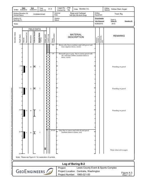
DrilledStart4/29/2010End4/29/2010TotalDepth (ft)31.5Logged ByChecked ByJTMTBDrillerBoretec Inc.DrillingMethodHollow Stem AugerSurface Elevation (ft)Vertical DatumUndeterminedHammerDataRope and Cathead140 (lb) 30-inch DropDrillingEquipmentTrack RigEasting (X)Northing (Y)Notes:SystemDatumGroundwaterDate Measured4/29/2010Depth toWater (ft)24.0Elevation (ft)FIELD DATAElevation (feet)Depth (feet)IntervalRecovered (in)Blows/footCollected SampleSample NameTestingWater LevelGraphic LogGroupClassificationMATERIALDESCRIPTIONMoistureContent, %Dry Density,(pcf)REMARKS0SMBrown silty fine to medium sand with gravel andtrace organics (loose, moist)GPBrownish gray to gray fine to coarse gravel withsilt, sand and cobbles (medium dense todense, moist)53261Pounding on gravelRedmond: Date:5/6/10 Path:W:\REDMOND\PROJECTS\1\1985021\00\GINT\198502100LOGS.GPJ DBTemplate/LibTemplate:GEOENGINEERS8.GDT/GEI8_GEOTECH_STANDARD1015318334023SP-SM206 29425Notes: Please see Figure A-1 for explanation <strong>of</strong> symbols.Gray fine to coarse sand with silt and gravel(medium dense to dense, wet)Log <strong>of</strong> Boring B-2Project: Lewis County Event & Sports ComplexProject Location: <strong>Centralia</strong>, WashingtonProject Number: 1985-021-00Pounding on gravelPounding on gravelWater observed in augersFigure A-3Sheet 1 <strong>of</strong> 2