

Surface Water Interaction Modelling Using Visual MODFLOW and GIS
Surface Water Interaction Modelling Using Visual MODFLOW and GIS
Surface Water Interaction Modelling Using Visual MODFLOW and GIS
- No tags were found...

Create successful ePaper yourself
Turn your PDF publications into a flip-book with our unique Google optimized e-Paper software.
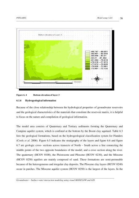
PHYLARESModel setup / ch.6__________________________________________________________________________________________36Figure 6. 4 Bottom elevation of layer 36.1.6 Hydrogeological informationBecause of the close relationship between the hydrological properties of groundwater reservoirs<strong>and</strong> the geological characteristics of the materials that constitute the reservoir matrix, it is helpfulto focus on the nature <strong>and</strong> compilation of geological information.The model area consists of Quaternary <strong>and</strong> Tertiary sediments forming the Quaternary <strong>and</strong>Campine aquifer system, which is confined at the bottom by the Boom clay aquitard. Table 6.3lists the geological formations, based on the hydrogeological classification system for Fl<strong>and</strong>ers(Cools et al. 2006). Figure 6.5 indicates the stratigraphy of the layers <strong>and</strong> figure 6.6 <strong>and</strong> figure6.7 are geologic cross- sections across transects of North – South across a line connecting themiddle points of the two opposite boundaries of the model, <strong>and</strong> a cross section along the river.The quaternary (HCOV 0100), the Pleistocene <strong>and</strong> Pliocene (HCOV 0230), <strong>and</strong> the Miocene(HCOV 0250) aquifers are mainly composed of s<strong>and</strong>. These formations are semi-permeablebecause of the heterogeneous <strong>and</strong> irregular clay deposits. The Pliocene clay layers (HCOV 0240)occur in patches. The Miocene aquifer system (HCOV 0250) is the largest of the layers. In the______________________________________________________________________________________Groundwater – <strong>Surface</strong> water interaction modeling using visual <strong>MODFLOW</strong> <strong>and</strong> <strong>GIS</strong>


