CUMULATIVE RISKS FROM EXPOSURE TOMULTIPLE AIR POLLUTANTSVulnerable groups as well as the general public areexposed every day dur<strong>in</strong>g normal activities to a varied array ofthousands of environmental pollutants <strong>in</strong> the air they bre<strong>at</strong>he,the w<strong>at</strong>er and beverages they dr<strong>in</strong>k, the food they e<strong>at</strong>, the surfacesthey touch, and the products they use. The cumul<strong>at</strong>iveeffects of this complex and ever-chang<strong>in</strong>g brew of environmentalstressors, <strong>in</strong>clud<strong>in</strong>g biological (e.g., Mycobacterium tuberculosis),chemical (e.g., 1,3-butadiene), physical (e.g., he<strong>at</strong>,noise), and psychosocial (e.g., job- or family-rel<strong>at</strong>ed stress)agents, may be critically important for accur<strong>at</strong>e assessment ofenvironmentally-<strong>in</strong>duced risks, <strong>in</strong>clud<strong>in</strong>g those rel<strong>at</strong>ed to airpollution. We know, for example, th<strong>at</strong> exposure to tobaccosmoke and asbestos or radon <strong>in</strong>creases the risk of develop<strong>in</strong>glung cancer over wh<strong>at</strong> would be expected from simple additionof <strong>in</strong>dividual effects. Moreover, there is evidence th<strong>at</strong> exposureto noise and toluene results <strong>in</strong> higher risk of hear<strong>in</strong>g loss thanfrom either stressor alone, th<strong>at</strong> exposure to polycyclic arom<strong>at</strong>ichydrocarbons and ultraviolet radi<strong>at</strong>ion <strong>in</strong>creases toxicity toaqu<strong>at</strong>ic organisms, and th<strong>at</strong> adults with <strong>in</strong>creased perceivedstress and children of parents experienc<strong>in</strong>g stress are moresusceptible to viral <strong>in</strong>fections.Thus, it is essential to keep <strong>in</strong> m<strong>in</strong>d th<strong>at</strong> the health risk ofany particular chemical <strong>in</strong> outdoor air is just a lone contributorto the cumul<strong>at</strong>ive risk from the sum of all chemicalsbre<strong>at</strong>hed <strong>in</strong> ambient air, which, <strong>in</strong> turn, is merely a share of thecumul<strong>at</strong>ive risk associ<strong>at</strong>ed with aggreg<strong>at</strong>e airborne chemicalexposures th<strong>at</strong> occur <strong>in</strong> all <strong>in</strong>door and outdoor environmentsand for all occup<strong>at</strong>ional and non-occup<strong>at</strong>ional activities.Even this is only part of the story, however, because to estim<strong>at</strong>ecumul<strong>at</strong>ive <strong>in</strong>hal<strong>at</strong>ion risk it is also necessarily to takeaccount of the effects from concurrent exposure to biological,physical, and psychosocial stressors. In the end, a realisticestim<strong>at</strong>e of cumul<strong>at</strong>ive health risks from total air pollutionexposure would have to <strong>in</strong>corpor<strong>at</strong>e not only consider<strong>at</strong>ion ofthe variables described above, but also of the contemporaneousrisks from all pert<strong>in</strong>ent routes of exposure (i.e., <strong>in</strong>hal<strong>at</strong>ion,<strong>in</strong>gestion, and dermal absorption) over all applicable temporaland sp<strong>at</strong>ial dimensions.In reality, comprehensive assessment of cumul<strong>at</strong>ive, airpollution-rel<strong>at</strong>ed health risk is presently precluded by the lackof appropri<strong>at</strong>e methods, measurements, and models to estim<strong>at</strong>erelevant exposures and rel<strong>at</strong>ed health effects. We are, forexample, unsure <strong>in</strong> most cases whether the comb<strong>in</strong>ed consequencesof <strong>in</strong>hal<strong>at</strong>ion exposure to multiple air pollutants arelikely to be <strong>in</strong>dependent (substances cause separ<strong>at</strong>e, unrel<strong>at</strong>edeffects), additive (effect of one substance adds to the other),synergistic (effects are more than additive), or antagonistic(effects are less than additive). In the absence of better <strong>in</strong>form<strong>at</strong>ion,it is common practice to assume th<strong>at</strong> risks are additivefor all airborne carc<strong>in</strong>ogens (regardless of type of cancer), andfor all systemic toxicants (i.e., caus<strong>in</strong>g chronic effects otherthan cancer, such as <strong>in</strong>jury to the respir<strong>at</strong>ory or nervous systems)th<strong>at</strong> affect the same organ system (e.g., respir<strong>at</strong>ory, cardiopulmonary,neurologic, reproductive).The bottom-l<strong>in</strong>e message is th<strong>at</strong> the risk c<strong>at</strong>egories discussedearlier are based solely on consider<strong>at</strong>ion of the healtheffects caused by ambient (outdoor) concentr<strong>at</strong>ions of each<strong>in</strong>dividual substance or group of substances act<strong>in</strong>g alone. Riskrank<strong>in</strong>gs might change, for <strong>in</strong>stance, if we took account of actualexposures, which are determ<strong>in</strong>ed by comb<strong>in</strong><strong>in</strong>g <strong>in</strong>form<strong>at</strong>ionabout (a) airborne concentr<strong>at</strong>ions <strong>in</strong> various <strong>in</strong>door and outdoorloc<strong>at</strong>ions, (<strong>in</strong>clud<strong>in</strong>g both occup<strong>at</strong>ional and non-occup<strong>at</strong>ionalsett<strong>in</strong>gs) through which people move, and (b) the time theyspend <strong>in</strong> each place (or microenvironment). Further modific<strong>at</strong>ionscould occur if the rank<strong>in</strong>gs factored <strong>in</strong> other cumul<strong>at</strong>iverisk issues, such as <strong>in</strong>teractions among multiple pollutants th<strong>at</strong>cause similar effects or the comb<strong>in</strong>ed vulnerabilities of highlyexposed popul<strong>at</strong>ions.A CASE STUDY - CUMULATIVE RISKS INA VULNERABLE COMMUNITYAt this po<strong>in</strong>t, it is useful to illustr<strong>at</strong>e how the characteristicsof popul<strong>at</strong>ions and neighborhoods can rel<strong>at</strong>e to sources ofhazardous air pollutants and put some people's health <strong>at</strong> muchgre<strong>at</strong>er risk. An earlier section <strong>in</strong>troduced the notion th<strong>at</strong> peoplemay be more vulnerable to pollution's health effects for avariety of reasons <strong>in</strong>clud<strong>in</strong>g whether they live closer to highconcentr<strong>at</strong>ions of pollutants, already suffer from disease or dis-20
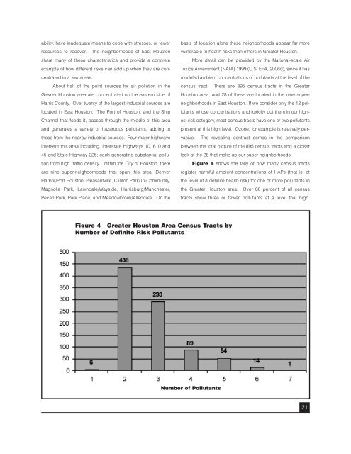
ability, have <strong>in</strong>adequ<strong>at</strong>e means to cope with stresses, or fewerresources to recover. The neighborhoods of East <strong>Houston</strong>share many of these characteristics and provide a concreteexample of how different risks can add up when they are concentr<strong>at</strong>ed<strong>in</strong> a few areas.About half of the po<strong>in</strong>t sources for air pollution <strong>in</strong> theGre<strong>at</strong>er <strong>Houston</strong> area are concentr<strong>at</strong>ed on the eastern side ofHarris County. Over twenty of the largest <strong>in</strong>dustrial sources areloc<strong>at</strong>ed <strong>in</strong> East <strong>Houston</strong>. The Port of <strong>Houston</strong>, and the ShipChannel th<strong>at</strong> feeds it, passes through the middle of this areaand gener<strong>at</strong>es a variety of hazardous pollutants, add<strong>in</strong>g tothose from the nearby <strong>in</strong>dustrial sources. Four major highways<strong>in</strong>tersect this area <strong>in</strong>clud<strong>in</strong>g, Interst<strong>at</strong>e Highways 10, 610 and45 and St<strong>at</strong>e Highway 225; each gener<strong>at</strong><strong>in</strong>g substantial pollutionfrom high traffic density. With<strong>in</strong> the City of <strong>Houston</strong>, thereare n<strong>in</strong>e super-neighborhoods th<strong>at</strong> span this area: DenverHarbor/Port <strong>Houston</strong>, Pleasantville, Cl<strong>in</strong>ton Park/Tri-Community,Magnolia Park, Lawndale/Wayside, Harrisburg/Manchester,Pecan Park, Park Place, and Meadowbrook/Allendale. On thebasis of loc<strong>at</strong>ion alone these neighborhoods appear far morevulnerable to health risks than others <strong>in</strong> Gre<strong>at</strong>er <strong>Houston</strong>.More detail can be provided by the N<strong>at</strong>ional-scale <strong>Air</strong>Toxics Assessment (NATA) 1999 (U.S. EPA, 2006d), s<strong>in</strong>ce it hasmodeled ambient concentr<strong>at</strong>ions of pollutants <strong>at</strong> the level of thecensus tract. There are 895 census tracts <strong>in</strong> the Gre<strong>at</strong>er<strong>Houston</strong> area, and 28 of these are loc<strong>at</strong>ed <strong>in</strong> the n<strong>in</strong>e superneighborhoods<strong>in</strong> East <strong>Houston</strong>. If we consider only the 12 pollutantswhose concentr<strong>at</strong>ions and toxicity put them <strong>in</strong> our highestrisk c<strong>at</strong>egory, most census tracts have one or two pollutantspresent <strong>at</strong> this high level. Ozone, for example is rel<strong>at</strong>ively pervasive.The reveal<strong>in</strong>g contrast comes <strong>in</strong> the comparisonbetween the total picture of the 895 census tracts and a closerlook <strong>at</strong> the 28 th<strong>at</strong> make up our super-neighborhoods.Figure 4 shows the tally of how many census tractsregister harmful ambient concentr<strong>at</strong>ions of HAPs (th<strong>at</strong> is, <strong>at</strong>the level of a def<strong>in</strong>ite health risk) for one or more pollutants <strong>in</strong>the Gre<strong>at</strong>er <strong>Houston</strong> area. Over 80 percent of all censustracts show three or fewer pollutants <strong>at</strong> a level th<strong>at</strong> high.Figure 4 Gre<strong>at</strong>er <strong>Houston</strong> Area Census Tracts byNumber of Def<strong>in</strong>ite Risk PollutantsNumber of Pollutants21
- Page 1 and 2: A Closer Look at Air Pollution in H
- Page 3 and 4: A Closer Look at Air Pollution in H
- Page 5 and 6: Task Force MembersResearch StaffKen
- Page 7 and 8: AcknowledgementsThe Task Force woul
- Page 10: Just because a task is difficult, h
- Page 13 and 14: ing, and route of exposure, and oth
- Page 15 and 16: and vulnerable subgroups. Substance
- Page 17 and 18: accurately from death certificates.
- Page 19 and 20: assessments, and monitoring data fr
- Page 21: The reality is that, even at simila
- Page 25 and 26: Houston reaches $21,701. These are
- Page 27 and 28: In summary, we view the comparative
- Page 29 and 30: AppendicesPhoto by Heidi Bethel27
- Page 31 and 32: Photo by Heidi Bethelgrouping to a
- Page 33 and 34: Appendix 2the time period is repres
- Page 35 and 36: Appendix 3an appreciable risk of ad
- Page 37 and 38: Table A3.1. Health Values and Refer
- Page 39 and 40: Table A3.1. Health Values and Refer
- Page 41 and 42: Table A3.1. Health Values and Refer
- Page 43 and 44: Appendix 4Metals, Diesel PM Convers
- Page 45 and 46: Under advice from staff at the U.S.
- Page 47 and 48: Appendix 5Table A5.1. Uncertain Ris
- Page 49 and 50: Appendix 6Brief Descriptions of Hea
- Page 51 and 52: Appendix 7Summary Map and Table for
- Page 53 and 54: Appendix 8: Table 1Supplemental Tab
- Page 55 and 56: Appendix 8: Table 3Table A8.3. Poss
- Page 57 and 58: ReferencesHackett, P., Sikov, M., &