CITY OF CHARLOTTETOWN: COMPREHENSIVE WATERFRONT MASTER PLAN<strong>Final</strong> <strong>Report</strong> • December 2012Sea Level Rise <strong>Report</strong>The <strong>Report</strong> Titled ‘Projecting and Visualizing Future Extreme Levels for Climate ChangeAdaptation in <strong>Charlottetown</strong> Harbour, Prince Edward Island, Canada’ written by Forbes, Webster,and MacDonald in 2012, summarizes the current understanding <strong>of</strong> sea level rise and extreme waterlevels in <strong>Charlottetown</strong> Harbour and presents information on the extent and depth <strong>of</strong> flooding thatmay be expected during severe storms over the next 100 years.The study presents three plausible scenarios for future high water levels in <strong>Charlottetown</strong> andsurrounding communities. The predictions combine these sea-level scenarios with statistics forstorm effects (combined tide and storm surge water levels) to project 100-year storm water levelsin 2100. The high water levels obtained for the three scenarios are as follows:««• 5.00 m Chart Datum, (3.31 m CGVD28)««• 5.28 m Chart Datum, (3.59 m CGVD28)««5.73 m Chart Datum, (4.04 m CGVD28)These numbers are respectively 0.77 m, 1.05 m and 1.50 m higher than the historic recordwater level.For planning purposes, the <strong>City</strong> <strong>of</strong> <strong>Charlottetown</strong> currently adopts a flooding prediction for theharbour derived from a 2002 study (McCulloch et al.). This prediction assumes a local sea-levelrise (including land subsidence) <strong>of</strong> 0.7 m over 100 years and suggests that a 100-year storm eventoccurring in 2100 could reach an elevation <strong>of</strong> 4.93 m Chart Datum, (3.24 m CGVD28).Additionally, the most conservative scenario is a minimum <strong>of</strong> 0.70 m higher than the waterlevel <strong>of</strong> the earlier study. The selection <strong>of</strong> a design-to water level for future planning purposesis ultimately a municipal planning policy decision. Nonetheless, these most up-to-date scenariosand their implications have been taken into serious consideration and will be addressed withinthe Master Plan.Stevenson Kellog <strong>Report</strong> (1973)In 1973, the Greater <strong>Charlottetown</strong> Urban Area Opportunity Study was released to assess theeconomic potential <strong>of</strong> the greater urban area now considered to be the downtown. At that timemany <strong>of</strong> the recommended projects were suggested to build on the tourism and conferencecentre potential <strong>of</strong> the city. The waterfront was seen as one <strong>of</strong> the catalytic development areasto leverage tourism potential. As such the plan for the waterfront (and the associated graphicimagery) showed small scale craft shops, restaurants, a waterfront hotel, a Maritime Museum,improvements to Great George Street, and several downtown parking structures. The report wasone <strong>of</strong> the most influential studies to transforming <strong>Charlottetown</strong> and resulted in Peakes Quay, theDelta Waterfront Hotel, Harbourside, upgrades to the Yacht Club, streetscape improvements forQueen, Water and Great George and the preservation <strong>of</strong> some <strong>of</strong> the cities heritage buildings. Thescale <strong>of</strong> development was not addressed and hence there was no guidance on the appropriateness<strong>of</strong> a 10 storey hotel bordered by 1 single storey Peakes Quay. The idea <strong>of</strong> using housing or <strong>of</strong>fice asa catalyst for groundfloor retail development was also not a focus <strong>of</strong> the plan, however, the veryfirst project <strong>of</strong> the plan (Harbourside) included many <strong>of</strong> the elements <strong>of</strong> a successful waterfronttoday including underground parking, ground floor retail and 1-2 storeys <strong>of</strong> residential above.Today, planners would reconfigure the buildings perpendicular to the waterfront so that the openspace is connected to the waterfront open space system and so that more units have waterfrontviews. In any case, this report still provides some good advice for the waterfront even thoughthe scale, waterfront principles and cultural practices <strong>of</strong> residents and tourists have changedconsiderably in 40 years.2.5 Site AnalysisA significant part <strong>of</strong> determining the direction and suggestions which the Master Plan willmake is based upon an analysis <strong>of</strong> the existing site conditions. During this process the team lookedat and evaluated the site with an honest and critical eye to determine what areas work and whatareas don’t. The conclusions <strong>of</strong> which inform the Master Plan. Coupled with this somewhat sitespecific analysis is a further study <strong>of</strong> Opportunities and Constraints, which looks at the broaderfactors at work which influence the potential growth and development <strong>of</strong> the site.22
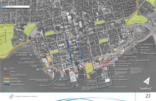
2.2Site Analysis <strong>Final</strong> <strong>Report</strong> • December 2012CITY OF CHARLOTTETOWN: COMPREHENSIVE WATERFRONT MASTER PLAN23