AAPG Explorer - American Association of Petroleum Geologists
AAPG Explorer - American Association of Petroleum Geologists
AAPG Explorer - American Association of Petroleum Geologists

Create successful ePaper yourself
Turn your PDF publications into a flip-book with our unique Google optimized e-Paper software.
<strong>AAPG</strong><br />
EXPLORER<br />
Sparsely drilled<br />
Scotian Basin Larger Than Gulf <strong>of</strong> Mexico<br />
By SUSAN R. EATON, EXPLORER Correspondent<br />
The Scotian Basin lies several<br />
hundred kilometers southwest <strong>of</strong><br />
Newfoundland’s oil producing Grand<br />
Banks. Larger than the Gulf <strong>of</strong> Mexico’s oil<br />
and gas producing area, the basin is 200<br />
kilometers wide, 800 kilometers long and<br />
142,000 square kilometers in size. Water<br />
depths vary from less than 100 meters to<br />
3,500 meters.<br />
The area contains up to 16,000 meters <strong>of</strong><br />
sediments.<br />
Sparsely explored to date, the Scotian<br />
Margin has been tested by just 204 wells,<br />
comprising 127 exploration wells, 28<br />
delineation wells and 49 production wells.<br />
Most were drilled between the 1970s-90s,<br />
on regional grids <strong>of</strong> low-fold, 2-D seismic<br />
data.<br />
Surprisingly, the area boasts 24<br />
significant discovery licenses, with an<br />
average exploration discovery rate <strong>of</strong> about<br />
25 percent.<br />
The first 3-D seismic surveys were<br />
acquired during the early 2000s, but huge<br />
areas <strong>of</strong> the basin have no 3-D seismic data<br />
coverage to date.<br />
The study’s data base consisted <strong>of</strong><br />
70,000 kilometers <strong>of</strong> 2-D seismic data,<br />
30,000 square kilometres <strong>of</strong> 3-D seismic<br />
data, and 20 key wells distributed across<br />
the basin. Some 7,300 kilometers <strong>of</strong> 2-D<br />
seismic trade data were reprocessed to<br />
modern-day standards.<br />
A full biostratigraphic analysis was<br />
conducted, and, according to <strong>AAPG</strong><br />
member Hamish Wilson, “We linked the<br />
40<br />
30<br />
20<br />
10<br />
0<br />
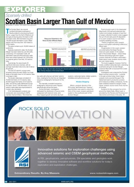
Resource Potential in the<br />
Nova Scotia Offshore Basin<br />
key wells with what we call ‘bible’ seismic<br />
lines, creating for the first time an integrated<br />
sequence stratigraphic framework for the<br />
basin.”<br />
Ten internally consistent sequence<br />
stratigraphic sequences were mapped<br />
geophysically across the basin.<br />
Across the basin, investigators<br />
delineated the distribution <strong>of</strong> source rocks<br />
juxtaposed with reservoir rocks, and<br />
they mapped growth and strike slip fault<br />
10 JULY 2011 WWW.<strong>AAPG</strong>.ORG<br />
14<br />
35<br />
Courtesy <strong>of</strong> RPS Energy Ltd.<br />
27<br />
ZONE RANKING by GAS volume IN PLACE<br />
GRAND TOTAL (unrisked) All Plays (in Tcf)<br />
Zone 1 Zone 3 Zone 5 Zone 6 Zone 4 Zone 2<br />
26<br />
16<br />
4.2<br />
3000<br />
2250<br />
1500<br />
750<br />
0<br />
2470<br />
1130<br />
ZONE RANKING by OIL volume IN PLACE<br />
GRAND TOTAL (unrisked) All Plays (in Mbbl)<br />
1650<br />
systems, carbonate banks, deltaic systems,<br />
turbidites and authochonous salt.<br />
1090<br />
Zone 1 Zone 3 Zone 5 Zone 6 Zone 4 Zone 2<br />
Scotian Basin map and data showing the resource potential <strong>of</strong> the six geographical zones for<br />
Play Fairway Analysis <strong>of</strong> the Scotian Basin.<br />
1<br />
2<br />
Window Shopping<br />
Wilson, program director <strong>of</strong> the<br />
PFA study, described how “forensic”<br />
geochemistry was used to unlock the<br />
story <strong>of</strong> the Lower Jurassic petroleum<br />
system in the southwest part <strong>of</strong> the<br />
Scotian Margin:<br />
3<br />
4<br />
5<br />
6<br />
990<br />
820<br />
Fluid inclusion work in the deepwater<br />
Weymouth A-45 well and extensive biomarker<br />
and isotopic analyses <strong>of</strong> sea floor<br />
oil seeps collected in piston cores suggest<br />
the syn-rift and early post-rift deposition<br />
<strong>of</strong> a Lower Jurassic source rock that’s<br />
currently expelling oil today.<br />
“There’s a regional Lower Jurassic<br />
source rock system extending to Morocco,”<br />
Wilson said.<br />
Oil generation in the Lower Jurassic<br />
occurred before the Deep Panuke<br />
reservoirs were sealed. In the eastern<br />
part <strong>of</strong> the Scotian Margin – where Deep<br />
Panuke will produce gas from Upper<br />
Jurassic Abenaki Formation carbonates –<br />
these same Lower Jurassic source rocks<br />
are over mature today.<br />
The study suggests, however, that the<br />
mostly undrilled carbonate bank, extending<br />
southwest along the Scotian Margin,<br />
could be filled with oil sourced from Lower<br />
Jurassic rocks.<br />
Investigators also analyzed the Scotian<br />
Basin’s proven source rocks – currently<br />
in the gas window today, these Upper<br />
Jurassic rocks sourced the gas in the<br />
Sable Sub-basin’s productive Jurassic<br />
and Cretaceous deltaic complexes. As the<br />
basin shallows toward its margins, these<br />
Upper Jurassic source rocks move into the<br />
oil window.<br />
Evidence for the concept <strong>of</strong> an oil rim<br />
around the Sable Delta, Wilson said, is<br />
provided by the Panuke and Penobscot oil<br />
discoveries and shows in this area. EXPLORER