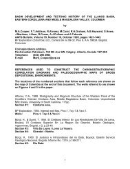
<strong>AAPG</strong> EXPLORER Play Fairway study available for free 400-KM Integrated Dataset Used in Study By SUSAN R. EATON, EXPLORER Correspondent Aeromagnetic, gravity and reflection seismic data were integrated with refraction seismic data – on both conjugate margins <strong>of</strong> the North Atlantic – to unravel the Scotian Margin’s history <strong>of</strong> rifting and drifting. In 2009, deploying 100 multi-component ocean bottom seismometers, the group acquired a 400-kilometer-long refraction seismic line across the Scotian Basin and the northeastern end WILSON <strong>of</strong> the East Coast Magnetic Anomaly (ECMA), a pronounced feature previously thought to delineate the northern limit <strong>of</strong> the basin’s rift footprint. The refraction line, shot in a dip orientation, imaged the Moho at an estimated depth <strong>of</strong> 40 kilometers. Investigators noted the existence <strong>of</strong> seaward dipping seismic reflectors along the entire Scotian Margin and across the Atlantic Ocean, in Morocco, suggesting the margin’s volcanic origin – and they interpreted a high velocity feature on the 2009 refraction line, pointing to the existence <strong>of</strong> a continuous, “under-plated body.” In other words, the ECMA doesn’t terminate because <strong>of</strong> reduced volcanic activity – rather, its magnetic signature is masked by an increased thickness <strong>of</strong> the overlying sedimentary package. But what does this tectonic analysis mean for oil and gas exploration? <strong>Geologists</strong> say it confirms that a volcanic margin runs along the entire length <strong>of</strong> the Scotian Basin to the southern Grand Banks, setting up a broad tectonic and depositional fairway for the development <strong>of</strong> an extensive Lower Jurassic source rock. 12 JULY 2011 WWW.<strong>AAPG</strong>.ORG Courtesy <strong>of</strong> OETR, Offshore Energy Technical Research <strong>Association</strong>, Halifax, Nova Scotia An excellent 3-D image <strong>of</strong> the Autochthonous salt basin <strong>of</strong> the Scotian Basin. ‘Bonanza’ Potential Integrating all <strong>of</strong> these diverse data sets was a monumental task undertaken by Paris-based Beicip-Franlab – the data were fed into a 3-D petroleum systems modeling package, leading to a predictive basin model for petroleum reservoir facies, source rocks and seals. The model calculated both qualitative and quantitative hydrocarbon volumes and associated risk factors for each <strong>of</strong> the six geographical zones, tripling the yet-to-find resource estimates (121 Tcf <strong>of</strong> natural gas and eight billion barrels <strong>of</strong> oil) for <strong>of</strong>fshore Nova Scotia in the process. The study’s final compilation, a Play Fairway Atlas consisting <strong>of</strong> 300-plus plates, is available for free to industry (www. novascotia<strong>of</strong>fshore.com). “An oil company can take the Atlas and start prospecting in the basin with the 10 horizons that are internally consistent and rigorously checked,” said <strong>AAPG</strong> member Hamish Wilson, program director <strong>of</strong> the PFA study and principal advisor with RPS Energy Ltd., Henley-on-Thames, England. “We set out to find reasons why the oil industry should come back to Nova Scotia,” Wilson continued, pointing to global competition in “hot” exploration areas on the West African conjugate margin. “We thought we might have to try to make a silk purse out <strong>of</strong> a sow’s ear.” But based on the study’s results, Wilson, like others, is bullish about the area’s potential. “I believe that our optimism is warranted,” he said. “There’s a rigorous science underpinning this Play Fairway Analysis. “There’s clearly a play risk here,” he continued, “but the seismically mapped structures are big enough, and there’s source rock. “If it works, it’s a bonanza for Nova Scotia.” EXPLORER
<strong>AAPG</strong> EXPLORER WWW.<strong>AAPG</strong>.ORG JULY 2011 13