AAPG Explorer - American Association of Petroleum Geologists
AAPG Explorer - American Association of Petroleum Geologists
AAPG Explorer - American Association of Petroleum Geologists

You also want an ePaper? Increase the reach of your titles
YUMPU automatically turns print PDFs into web optimized ePapers that Google loves.
<strong>AAPG</strong><br />
EXPLORER<br />
36 JULY 2011 WWW.<strong>AAPG</strong>.ORG<br />
Denise M. Stone is an <strong>AAPG</strong> member and geological consultant in<br />
Houston. She is editing an <strong>AAPG</strong> publication in progress, “Oil and Gas<br />
Fields <strong>of</strong> the Cook Inlet <strong>of</strong> Alaska,” which should be available in 2012.<br />
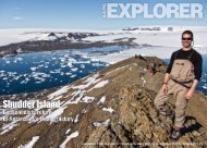
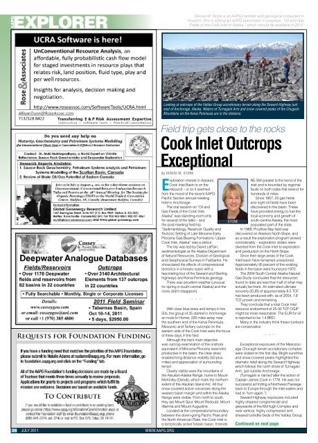
Looking at outcrops <strong>of</strong> the Valdez Group accretionary terrain along the Seward Highway just<br />
east <strong>of</strong> Anchorage, Alaska. Waters <strong>of</strong> Turnagain Arm and snow covered peaks <strong>of</strong> the Chugach<br />
Mountains on the Kenai Peninsula are in the distance.<br />
Field trip gets close to the rocks<br />
Cook Inlet Outcrops<br />
Exceptional<br />
By DENISE M. STONE<br />
Exploration interest in Alaska’s<br />
Cook Inlet Basin is on the<br />
rebound – or so it seemed<br />
from the mood <strong>of</strong> the recent <strong>AAPG</strong><br />
Pacific Section annual meeting<br />
held in Anchorage.<br />
The oral session on “Oil and<br />
Gas Fields <strong>of</strong> the Cook Inlet,<br />
Alaska” was standing-room-only<br />
for several <strong>of</strong> the talks – and<br />
the post-meeting field trip<br />
“Sedimentology, Reservoir Quality and<br />
Tectonic Setting <strong>of</strong> Late Miocene-Early<br />
Pliocene Gas-Bearing Formations, Upper<br />
Cook Inlet, Alaska” was a sellout.<br />
The trip was led by David LePain,<br />
sedimentologist at the Alaska Department<br />
<strong>of</strong> Natural Resources, Division <strong>of</strong> Geological<br />
and Geophysical Surveys in Fairbanks. He<br />
showcased the effects <strong>of</strong> compressional<br />
tectonics in a forearc basin with a<br />
fascinating tour <strong>of</strong> the Seward and Sterling<br />
highways and Kenai Peninsula geology.<br />
There was excellent weather (unusual<br />
for spring in south-central Alaska) and the<br />
rocks didn’t disappoint.<br />
* * *<br />
With clear blue skies and temps in the<br />
50s, the group <strong>of</strong> 25 started in Anchorage<br />
en route to Homer, 220 miles away near<br />
the southern end <strong>of</strong> the Kenai Peninsula.<br />
Mesozoic and Tertiary outcrops on the<br />
eastern side <strong>of</strong> the Cook Inlet were the focus<br />
<strong>of</strong> three days in the field.<br />
Although the trip’s main objective<br />
was outcrop examination <strong>of</strong> the onshore<br />
equivalent <strong>of</strong> Miocene-Pliocene reservoirs<br />
productive in the basin, the clear skies<br />
enabled long distance visibility (50-plus<br />
miles) and appreciation <strong>of</strong> surrounding<br />
terrain.<br />
Clearly visible were the mountains <strong>of</strong><br />
the Aleutian-Alaska Range, home to Mount<br />
McKinley (Denali), which mark the northern<br />
extent <strong>of</strong> the Aleutian Island Arc. All four<br />
snow-covered active volcanoes along the<br />
western basin margin and within the Alaska<br />
Range were visible. From north to south,<br />
they are Mount Spur, Mount Redoubt, Mount<br />
Illiamna and Mount Augustine.<br />
Located at the compressional boundary<br />
between the down-going Pacific Plate and<br />
the North <strong>American</strong> Plate, the Cook Inlet is<br />
a tectonically active forearc basin. It trends<br />
STONE<br />
NE-SW parallel to the trend <strong>of</strong> the<br />
inlet and is bounded by regional<br />
faults on both sides that extend for<br />
hundreds <strong>of</strong> miles.<br />
Since 1957, 23 gas fields<br />
and eight oil fields have been<br />
discovered in the basin. These<br />
have provided energy to fuel the<br />
local economy and growth <strong>of</strong><br />
south-central Alaska, the most<br />
populated part <strong>of</strong> the state.<br />
In 1968, Prudhoe Bay field was<br />
discovered on Alaska’s North Slope, and<br />
as a result the exploration program slowed<br />
considerably – exploration dollars were<br />
diverted from the Cook Inlet to exploration<br />
and production on the North Slope.<br />
Since then large areas <strong>of</strong> the Cook<br />
Inlet basin have remained unexplored.<br />
Approximately 95 percent <strong>of</strong> the existing<br />
fields in the basin were found pre-1970.<br />
The 2004 South Central Alaska Natural<br />
Gas Study concluded that the resources<br />
found to date are less than half <strong>of</strong> what may<br />
actually be there. An estimated ultimate<br />
recovery (EUR) <strong>of</strong> approximately 8.5 TCF<br />
has been produced with, as <strong>of</strong> 2004, 1.8<br />
TCF proven and remaining.<br />
They conclude that a total Cook Inlet<br />
resource endowment <strong>of</strong> 25-30 TCF OGIP<br />
might be more reasonable. The EUR for oil<br />
is reported to be 1.4 BBO.<br />
Many in the industry think these numbers<br />
are conservative.<br />
* * *<br />
Exceptional exposures <strong>of</strong> the Mesozoicage<br />
Chucagh terrain accretionary complex<br />
were visited on the first day. Bright sunshine<br />
and snow-covered peaks highlighted the<br />
dramatic relief along the Seward Highway,<br />
which follows the north shore <strong>of</strong> Turnagain<br />
Arm, just outside Anchorage.<br />
(Turnagain is named after the action <strong>of</strong><br />
Captain James Cook in 1778. He was not<br />
successful at finding a Northwest Passage<br />
back to Europe through the inlet waters and<br />
had to “turn again.”)<br />
Seward Highway exposures included<br />
highly sheared conglomerate and<br />
greywacke <strong>of</strong> the McHugh Complex and<br />
near vertical, highly compressed and<br />
sheared turbidite beds <strong>of</strong> the Valdez Group.<br />
Continued on next page