Durrington CAA_doc.qxp - Wiltshire Council
Durrington CAA_doc.qxp - Wiltshire Council
Durrington CAA_doc.qxp - Wiltshire Council
- No tags were found...

Create successful ePaper yourself
Turn your PDF publications into a flip-book with our unique Google optimized e-Paper software.
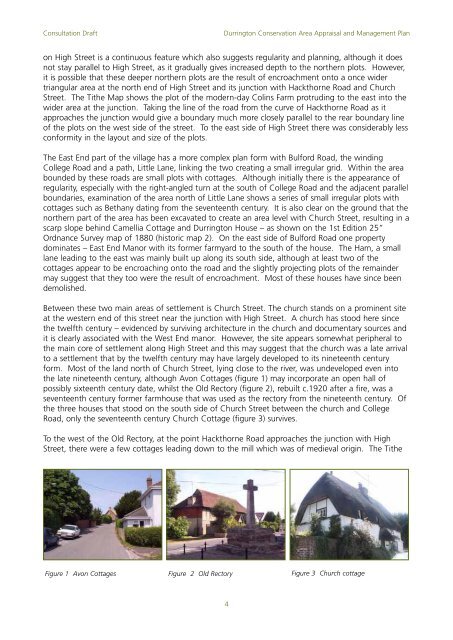
Consultation Draft<strong>Durrington</strong> Conservation Area Appraisal and Management Planon High Street is a continuous feature which also suggests regularity and planning, although it doesnot stay parallel to High Street, as it gradually gives increased depth to the northern plots. However,it is possible that these deeper northern plots are the result of encroachment onto a once widertriangular area at the north end of High Street and its junction with Hackthorne Road and ChurchStreet. The Tithe Map shows the plot of the modern-day Colins Farm protruding to the east into thewider area at the junction. Taking the line of the road from the curve of Hackthorne Road as itapproaches the junction would give a boundary much more closely parallel to the rear boundary lineof the plots on the west side of the street. To the east side of High Street there was considerably lessconformity in the layout and size of the plots.The East End part of the village has a more complex plan form with Bulford Road, the windingCollege Road and a path, Little Lane, linking the two creating a small irregular grid. Within the areabounded by these roads are small plots with cottages. Although initially there is the appearance ofregularity, especially with the right-angled turn at the south of College Road and the adjacent parallelboundaries, examination of the area north of Little Lane shows a series of small irregular plots withcottages such as Bethany dating from the seventeenth century. It is also clear on the ground that thenorthern part of the area has been excavated to create an area level with Church Street, resulting in ascarp slope behind Camellia Cottage and <strong>Durrington</strong> House – as shown on the 1st Edition 25”Ordnance Survey map of 1880 (historic map 2). On the east side of Bulford Road one propertydominates – East End Manor with its former farmyard to the south of the house. The Ham, a smalllane leading to the east was mainly built up along its south side, although at least two of thecottages appear to be encroaching onto the road and the slightly projecting plots of the remaindermay suggest that they too were the result of encroachment. Most of these houses have since beendemolished.Between these two main areas of settlement is Church Street. The church stands on a prominent siteat the western end of this street near the junction with High Street. A church has stood here sincethe twelfth century – evidenced by surviving architecture in the church and <strong>doc</strong>umentary sources andit is clearly associated with the West End manor. However, the site appears somewhat peripheral tothe main core of settlement along High Street and this may suggest that the church was a late arrivalto a settlement that by the twelfth century may have largely developed to its nineteenth centuryform. Most of the land north of Church Street, lying close to the river, was undeveloped even intothe late nineteenth century, although Avon Cottages (figure 1) may incorporate an open hall ofpossibly sixteenth century date, whilst the Old Rectory (figure 2), rebuilt c.1920 after a fire, was aseventeenth century former farmhouse that was used as the rectory from the nineteenth century. Ofthe three houses that stood on the south side of Church Street between the church and CollegeRoad, only the seventeenth century Church Cottage (figure 3) survives.To the west of the Old Rectory, at the point Hackthorne Road approaches the junction with HighStreet, there were a few cottages leading down to the mill which was of medieval origin. The TitheFigure 1 Avon CottagesFigure 2 Old RectoryFigure 3 Church cottage4