19The seaward extent of the coastal environment extends 12 nautical miles from MHWS and is administered byEnvironment Canterbury. However, whilst Motunau Island is situated in Environment Canterbury's jurisdiction (seawardof the MHWS) it is part of the Hurunui District's responsibility. Although the Hurunui coastline is, for the majority of itslength, generally uniform, specific attention needs to be given to more complex areas, including Gore Bay, river mouthsand areas of bays and beaches.A general rule of thumb is that the inland extent of the coastal environment extends to the first [proximate] significantridgeline inland of the coast, although for flat areas, the boundaries are determined more by landscape character andwhere coastal elements, patterns and processes are still sufficiently significant. The ‘first ridge’ concept has recently beendiscussed in the Mt. Cass Environment Court decision regarding a wind farm proposal:“[320] The Hurunui Commissioners, referring to case law, were persuaded that the coastal environment boundary shouldbe at the dominant landward ridge, which they identified as Mt Cass. We accept that Mt Cass is a dominant ridge andthat glimpses of it can be seen from some parts of the Hurunui coastline. In other cases before the Environment Courta landward ridge has been adopted as a boundary to a coastal environment. However, where a dominant ridge maybe a useful means to identify a coastal environment boundary, such a boundary should be relevant to the coastlineand coastal environment. There is no necessity to identify a dominant ridge in each case, particularly one that may bekilometres away from the coast. In any event we are satisfied that the effects on natural character and landscape wouldnot extend to that area which could properly be considered to be coastal environment of Hurunui.[321] We find that Mt Cass ridge and the dip slope landward of the ridge is not within the coastal environmentand neither is any part of the wind farm. By contending that the coastal environment has an extreme reach, we areconcerned that attention could be drawn from the importance of the coastline and derogate from the focus of section6(a).”Fundamental to this assessment of the Coastal Environment nt is the relevant and accessible data available to informjudgements. This is listed in the Mapping Information on section. The use ofprofessional knowledge of the study teamin relation to the elements outlined within Policy 1 of the NZCPS 2010 was also an essential source of information.Few components listed under Policy 1 have been excluded, whichinclude cultural and historical aspects and benthic/bathometry studies, since limited information was available.The mapping and assessment scale for this task is ‘for thedistrict’.Mapping InformationDRAFTThe scale of the natural character study is critical to the validity of the end results. As outlined earlier, natural characterassessment is scale related and determined by the study brief and to varying extents by the mapping scale of the informationused to determine the outcomes of the project. For this project, the scale is the region, although as describedearlier, mapping is at a district level.SECTION CThe assessment was primarily based on a desktop study and an aerial survey with limited ground-truthing. GIS hasbeen used to systematically map the extent of the Coastal Environment and to map coastal areas. The mapping scaleundertaken for this project is 1:50,000. It is acknowledged that the majority of the data used for this study is at scalesgreater than 1:50,000. The mapping has been undertaken on high resolution aerial images, although presented in thisreport on 1:50,000 topographical maps. Where more intricate sections of the coastline exist, these have been mappedat a finer scale. At these finer scales, GIS allows the viewer to zoom in and assess the exact location of the coastalenvironment. However, extent of the coastal environment and coastal area boundaries in this study were mapped withinthe context of the Canterbury region as a whole and with reference to surrounding broad geographical features, notpaddock by paddock. This broader context should be borne in mind. For a list of GIS information refer to Appendix 4.Hurunui District | <strong>2013</strong>
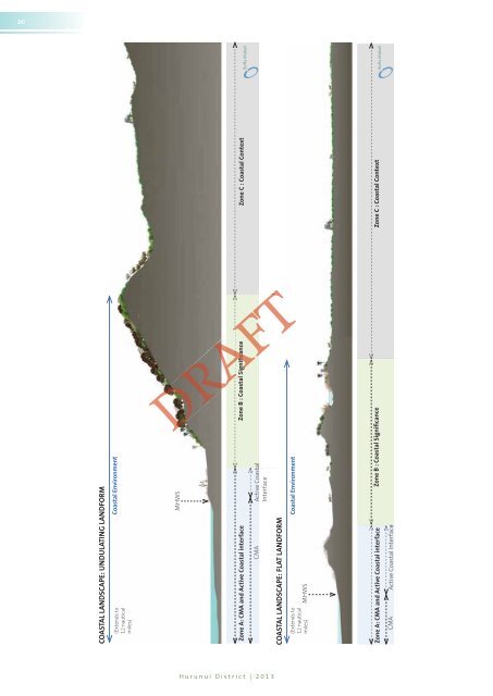
20COASTAL LANDSCAPE: UNDULATING LANDFORM(Extends to12 nauticalmiles)Coastal EnvironmentMHWSZone A: CMA and Active Coastal interfaceCOASTAL LANDSCAPE: FLAT LANDFORM(Extends to12 nauticalmiles)MHWSCMA Active CoastalInterfaceCoastal EnvironmentTZone B : Coastal SignificanceZone A: CMA and Active Coastal interfaceZone B : Coastal SignificanceCMAActive Coastal InterfaceeZone C : Coastal ContextZone C : Coastal ContextRAFTFTHurunui District | <strong>2013</strong>