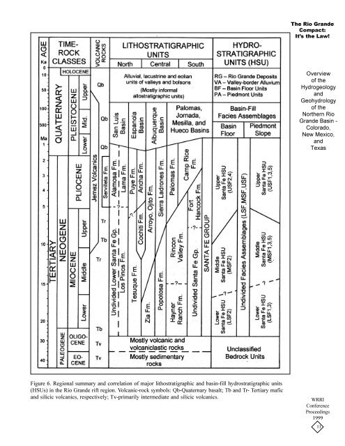
Hydrostratigraphic UnitsMost intermontane-basin fills in <strong>the</strong> NewMexico region have been subdivided into twomajor lithostratigraphic units (Figure 6), <strong>the</strong>Santa Fe Group in <strong>Rio</strong> <strong>Grande</strong> rift basins (e.g.,Hawley 1978; Chapin and Ca<strong>the</strong>r 1994) and <strong>the</strong>Gila Group in basins <strong>of</strong> <strong>the</strong> Mexican Highlandand Datil-Mogollon sections to <strong>the</strong> west (Hawleyet al. 2000). In addition, a clear distinction hasrarely been made between deposits simply classedas “bolson” or “basin” fill and contiguous (formaland informal) subdivisions <strong>of</strong> <strong>the</strong> Santa Fe andGila groups. As a first step in organizing availableinformation on basin fill stratigraphy that hasa close relationship with aquifer characteristics, aprovisional hydrostratigraphic classificationsystem (Seaber 1988) has been developed. Itfollows guidelines used successfully in <strong>the</strong>Albuquerque and Mesilla basins (Hawley andLozinsky 1992; Hawley et al. 1995) and inadjacent “Southwest Alluvial <strong>Basin</strong>s” as definedby Wilkins (1986, 1998).Hydrostratigraphic units defined in <strong>the</strong> RGRregion are mappable bodies <strong>of</strong> basin fill andvalley fill that are grouped on <strong>the</strong> basis <strong>of</strong> originand position in both lithostratigraphic and chronostratigraphicsequences. The informal upper,middle, and lower Santa Fe hydrostratigraphicunits (HSUs: USF, MSF, LSF) comprise <strong>the</strong>major basin-fill aquifer zones, and <strong>the</strong>y correspondroughly to <strong>the</strong> (formal and informal) upper,middle, and lower lithostratigraphic subdivisions<strong>of</strong> <strong>the</strong> Santa Fe Groups used in local and regionalgeologic mapping (Figure 6). Dominant lith<strong>of</strong>aciesassemblages in <strong>the</strong> upper Santa Fe HSUare LFAs 1-3, 5 and 6. The middle Santa FeHSU is characterized by LFAs 3, 4, 7-9, and <strong>the</strong>lower Santa Fe commonly comprises LFAs 9, 7-10. <strong>Basin</strong>-floor facies assemblages 3 and 9 arecommonly present throughout <strong>the</strong> Santa Fe Groupsection in closed-basin (bolson) areas.The o<strong>the</strong>r major hydrostratigraphic unitscomprise channel and floodplain deposits <strong>of</strong> <strong>the</strong><strong>Rio</strong> <strong>Grande</strong> (RG) and its major tributaries such as<strong>the</strong> <strong>Rio</strong> Chama and <strong>Rio</strong> Puerco. These valley fills<strong>of</strong> Late Quaternary age form <strong>the</strong> upper part <strong>of</strong><strong>the</strong> region’s most productive shallow-aquifersystem (LFAa). Surficial lake and playa deposits,fills <strong>of</strong> larger arroyo valleys, and piedmont-slopealluvium are primarily in <strong>the</strong> vadose zone.However, <strong>the</strong>y locally form important groundwaterdischarge and recharge sites. Historicalphreatic conditions exist, or have recently existed,in a few playa remnants <strong>of</strong> large pluvial lakes <strong>of</strong>Late Quaternary age (Hawley 1993). Notableexamples are “gypsum or alkali flats” in <strong>the</strong>Tularosa, Jornada del Muerto and Los Muertosbasins, which are contiguous to, but outside <strong>the</strong>area discussed in this paper.Bedrock and Structural Boundary ComponentsStructural and bedrock features that influenceaquifer composition and behavior include basinboundarymountain uplifts, bedrock units beneath<strong>the</strong> basin-fill, fault zones and flexures within andat <strong>the</strong> edges <strong>of</strong> basins, and igneous-intrusive andextrusive rocks that penetrate or are interbeddedwith basin fill. Tectonic evolution <strong>of</strong> <strong>the</strong> faultblockbasins and ranges <strong>of</strong> <strong>the</strong> study area (manywith a half-graben structure and accommodationzoneterminations) has had a pr<strong>of</strong>ound effect on<strong>the</strong> distribution <strong>of</strong> lith<strong>of</strong>acies assemblages and <strong>the</strong>timing and style <strong>of</strong> emplacement <strong>of</strong> all majorhydrostratigraphic units (Figs. 5 and 6). Discussion<strong>of</strong> this topic is beyond <strong>the</strong> scope <strong>of</strong> thispaper, however, <strong>the</strong> reader is referred to pertinentreviews in Collins and Raney (1991), Keller andCa<strong>the</strong>r (1994), Hawley and o<strong>the</strong>rs (1995), Bauerand o<strong>the</strong>rs (1995), G<strong>of</strong>f and o<strong>the</strong>rs (1996), Mackand o<strong>the</strong>rs (1997, 1998), Faulds and Varga(1998), Haneberg (1998), and Pazzaglia andLucas (1999).HYDROGEOLOGIC FRAMEWORK OFREPRESENTATIVE RGR BASINSFigures 7, 8, and 9 are schematic hydrogeologiccross-sections that illustrate <strong>the</strong> basicstructural framework and distribution patterns <strong>of</strong>major hydrostratigraphic units, respectively, in <strong>the</strong>central parts <strong>of</strong> <strong>the</strong> San Luis, Albuquerque, andMesilla basins <strong>of</strong> <strong>the</strong> <strong>Rio</strong> <strong>Grande</strong> rift structuralprovince. In addition to parts <strong>of</strong> <strong>the</strong> Española<strong>Basin</strong> near Los Alamos and <strong>the</strong> Hueco Bolsonnear El Paso (Purtymun 1995; Cliett and Hawley1996), <strong>the</strong>se are <strong>the</strong> only areas where high-qualityborehole geophysical and sample logs, and avariety <strong>of</strong> o<strong>the</strong>r geophysical and geochemicalsurvey data are available. It is important to notethat much <strong>of</strong> this information is related to deep-The <strong>Rio</strong> <strong>Grande</strong>Compact:It’s <strong>the</strong> Law!<strong>Overview</strong><strong>of</strong> <strong>the</strong>HydrogeologyandGeohydrology<strong>of</strong> <strong>the</strong>Nor<strong>the</strong>rn <strong>Rio</strong><strong>Grande</strong> <strong>Basin</strong> -Colorado,New Mexico,andTexasWRRIConferenceProceedings199910
The <strong>Rio</strong> <strong>Grande</strong>Compact:It’s <strong>the</strong> Law!<strong>Overview</strong><strong>of</strong> <strong>the</strong>HydrogeologyandGeohydrology<strong>of</strong> <strong>the</strong>Nor<strong>the</strong>rn <strong>Rio</strong><strong>Grande</strong> <strong>Basin</strong> -Colorado,New Mexico,andTexasFigure 6. Regional summary and correlation <strong>of</strong> major lithostratigraphic and basin-fill hydrostratigraphic units(HSUs) in <strong>the</strong> <strong>Rio</strong> <strong>Grande</strong> rift region. Volcanic-rock symbols: Qb-Quaternary basalt; Tb and Tr- Tertiary maficand silicic volcanics, respectively; Tv-primarily intermediate and silicic volcanics.WRRIConferenceProceedings199911