Overview of the Groundwater Hydrology of the Rio Grande Basin
Overview of the Groundwater Hydrology of the Rio Grande Basin
Overview of the Groundwater Hydrology of the Rio Grande Basin

You also want an ePaper? Increase the reach of your titles
YUMPU automatically turns print PDFs into web optimized ePapers that Google loves.
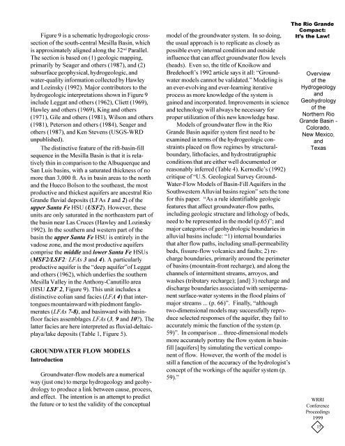
Figure 9 is a schematic hydrogeologic crosssection<strong>of</strong> <strong>the</strong> south-central Mesilla <strong>Basin</strong>, whichis approximately aligned along <strong>the</strong> 32 nd Parallel.The section is based on (1) geologic mapping,primarily by Seager and o<strong>the</strong>rs (1987), and (2)subsurface geophysical, hydrogeologic, andwater-quality information collected by Hawleyand Lozinsky (1992). Major contributors to <strong>the</strong>hydrogeologic interpretations shown in Figure 9include Leggat and o<strong>the</strong>rs (1962), Cliett (1969),Hawley and o<strong>the</strong>rs (1969), King and o<strong>the</strong>rs(1971), Gile and o<strong>the</strong>rs (1981), Wilson and o<strong>the</strong>rs(1981), Peterson and o<strong>the</strong>rs (1984), Seager ando<strong>the</strong>rs (1987), and Ken Stevens (USGS-WRDunpublished).The distinctive feature <strong>of</strong> <strong>the</strong> rift-basin-fillsequence in <strong>the</strong> Mesilla <strong>Basin</strong> is that it is relativelythin in comparison to <strong>the</strong> Albuquerque andSan Luis basins, with a saturated thickness <strong>of</strong> nomore than 3,000 ft. As in basin areas to <strong>the</strong> northand <strong>the</strong> Hueco Bolson to <strong>the</strong> sou<strong>the</strong>ast, <strong>the</strong> mostproductive and thickest aquifers are ancestral <strong>Rio</strong><strong>Grande</strong> fluvial deposits (LFAs 1 and 2) <strong>of</strong> <strong>the</strong>upper Santa Fe HSU (USF2). However, <strong>the</strong>seunits are only saturated in <strong>the</strong> nor<strong>the</strong>astern part <strong>of</strong><strong>the</strong> basin near Las Cruces (Hawley and Lozinsky1992). In <strong>the</strong> sou<strong>the</strong>rn and western part <strong>of</strong> <strong>the</strong>basin <strong>the</strong> upper Santa Fe HSU is entirely in <strong>the</strong>vadose zone, and <strong>the</strong> most productive aquiferscomprise <strong>the</strong> middle and lower Santa Fe HSUs(MSF2/LSF2: LFAs 3 and 4). A particularlyproductive aquifer is <strong>the</strong> “deep aquifer”<strong>of</strong> Leggatand o<strong>the</strong>rs (1962), which underlies <strong>the</strong> sou<strong>the</strong>rnMesilla Valley in <strong>the</strong> Anthony-Canutillo area(HSU LSF 2, Figure 9). This unit includes adistinctive eolian sand facies (LFA 4) that intertonguesmountainward with piedmont fanglomerates(LFAs 7-8), and basinward with basinfloorfacies assemblages LFAs (3, 9 and 10?). Thelatter facies are here interpreted as fluvial-deltaicplaya/lakedeposits (Table 1, Figure 5).GROUNDWATER FLOW MODELSIntroduction<strong>Groundwater</strong>-flow models are a numericalway (just one) to merge hydrogeology and geohydrologyto produce a link between cause, process,and effect. The intention is an attempt to predict<strong>the</strong> future or to test <strong>the</strong> validity <strong>of</strong> <strong>the</strong> conceptualmodel <strong>of</strong> <strong>the</strong> groundwater system. In so doing,<strong>the</strong> usual approach is to replicate as closely aspossible every internal condition and outsideinfluence that can affect groundwater flow levels(heads). Even so, <strong>the</strong> title <strong>of</strong> Knoikow andBredehoeft’s 1992 article says it all: “<strong>Groundwater</strong>models cannot be validated.” Modeling isan ever-evolving and ever-learning iterativeprocess as more knowledge <strong>of</strong> <strong>the</strong> system isgained and incorporated. Improvements in scienceand technology will always be necessary forproper utilization <strong>of</strong> this new knowledge base.Models <strong>of</strong> groundwater flow in <strong>the</strong> <strong>Rio</strong><strong>Grande</strong> <strong>Basin</strong> aquifer system first need to beexamined in terms <strong>of</strong> <strong>the</strong> hydrogeologic constraintsplaced on flow regimes by structuralboundary,lith<strong>of</strong>acies, and hydrostratigraphicconditions that are ei<strong>the</strong>r well documented orreasonably inferred (Table 4). Kernodle’s (1992)critique <strong>of</strong> “U.S. Geological Survey Ground-Water-Flow Models <strong>of</strong> <strong>Basin</strong>-Fill Aquifers in <strong>the</strong>Southwestern Alluvial basins region” sets <strong>the</strong> tonefor this paper. “As a rule identifiable geologicfeatures that affect groundwater-flow paths,including geologic structure and lithology <strong>of</strong> beds,need to be represented in <strong>the</strong> model (p.65)”; andmajor categories <strong>of</strong> geohydrologic boundaries inalluvial basins include: “1) internal boundariesthat alter flow paths, including small-permeabilitybeds, fissure-flow volcanics and faults; 2) rechargeboundaries, primarily around <strong>the</strong> perimeter<strong>of</strong> basins (mountain-front recharge), and along <strong>the</strong>channels <strong>of</strong> intermittent streams, arroyos, andwashes (tributary recharge); [and] 3) recharge anddischarge boundaries associated with semipermanentsurface-water systems in <strong>the</strong> flood plains <strong>of</strong>major streams ... (p. 66)”. Finally, “althoughtwo-dimensional models may successfully reproduceselected responses <strong>of</strong> <strong>the</strong> aquifer, <strong>the</strong>y fail toaccurately mimic <strong>the</strong> function <strong>of</strong> <strong>the</strong> system (p.59)”. In comparison ... three-dimensional modelsmore accurately portray <strong>the</strong> flow system in basinfill[aquifers] by simulating <strong>the</strong> vertical component<strong>of</strong> flow. However, <strong>the</strong> worth <strong>of</strong> <strong>the</strong> model isstill a function <strong>of</strong> <strong>the</strong> accuracy <strong>of</strong> <strong>the</strong> hydrologist’sconcept <strong>of</strong> <strong>the</strong> workings <strong>of</strong> <strong>the</strong> aquifer system (p.59).”The <strong>Rio</strong> <strong>Grande</strong>Compact:It’s <strong>the</strong> Law!<strong>Overview</strong><strong>of</strong> <strong>the</strong>HydrogeologyandGeohydrology<strong>of</strong> <strong>the</strong>Nor<strong>the</strong>rn <strong>Rio</strong><strong>Grande</strong> <strong>Basin</strong> -Colorado,New Mexico,andTexasWRRIConferenceProceedings199915