Overview of the Groundwater Hydrology of the Rio Grande Basin
Overview of the Groundwater Hydrology of the Rio Grande Basin
Overview of the Groundwater Hydrology of the Rio Grande Basin

You also want an ePaper? Increase the reach of your titles
YUMPU automatically turns print PDFs into web optimized ePapers that Google loves.
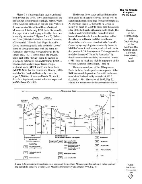
Figure 7 is a hydrogeologic section, adaptedfrom Brister and Gries, 1994, that documents <strong>the</strong>half-graben structure and relatively narrow width<strong>of</strong> <strong>the</strong> Alamosa subbasin <strong>of</strong> <strong>the</strong> San Luis Valley in<strong>the</strong> area west <strong>of</strong> Great Sand Dunes NationalMonument. It is <strong>the</strong> only RGR basin discussed inthis paper that is both topographically closed andinternally drained (cf. Figures 2 and 3). Bristerand Gries (1994) include <strong>the</strong> Alamosa Formation<strong>of</strong> Siebenthal (1910) in <strong>the</strong>ir Upper Santa FeGroup lithostratigraphic unit, and <strong>the</strong>ir “Lower”Santa Fe Group correlates with <strong>the</strong> Santa FeFormation <strong>of</strong> previous workers (Powell 1958;Emery et al. 1971). In this paper <strong>the</strong> gravellyupper part <strong>of</strong> <strong>the</strong> “lower” Santa Fe section isinformally defined as <strong>the</strong> middle Santa Fe HSU,which comprises two major facies groups,piedmont slope (MSF1 and 3) and basin floor(MSF2). Note that <strong>the</strong> Hearne and Dewey (1988)model <strong>of</strong> <strong>the</strong> San Luis <strong>Basin</strong> only covers <strong>the</strong>upper 3,200 feet <strong>of</strong> saturated basin fill, and it,<strong>the</strong>refore, is primarily restricted to <strong>the</strong> upper andmiddle Santa Fe HSUs.The Brister-Gries study utilized informationfrom cross-basin seismic-survey lines as well assample and geophysical logs from deep boreholes.As shown in Figure 7, <strong>the</strong> Santa Fe Group islocally as much as 9,500 ft. thick near <strong>the</strong> easternedge <strong>of</strong> <strong>the</strong> half-graben (hanging-wall) block. Thisstudy also demonstrates that Santa Fe Groupbasin fill is relatively thin in <strong>the</strong> western half <strong>of</strong><strong>the</strong> Alamosa subbasin, and that most basindeposits heret<strong>of</strong>ore correlated with <strong>the</strong> Santa FeGroup by hydrogeologists are actually Lower toMiddle Cenozoic sedimentary and volcanic rocksthat predate RGR development. This suggests thatmodel estimates <strong>of</strong> “Santa Fe Formation” hydraulicconductivity made by Hearne and Dewey(1988) may be much too high in large parts <strong>of</strong> <strong>the</strong>western Alamosa subbasin (cf. Table 4).The east-central part <strong>of</strong> <strong>the</strong> Albuquerque<strong>Basin</strong> includes <strong>the</strong> deepest known segment <strong>of</strong> <strong>the</strong>RGR structural depression. <strong>Basin</strong> fill in <strong>the</strong> areanear Isleta Pueblo locally exceeds 14,500 ft.(Lozinsky 1994; Hawley et al. 1995, Fig. 3).Figure 8 is a schematic hydrogeologic section <strong>of</strong>The <strong>Rio</strong> <strong>Grande</strong>Compact:It’s <strong>the</strong> Law!<strong>Overview</strong><strong>of</strong> <strong>the</strong>HydrogeologyandGeohydrology<strong>of</strong> <strong>the</strong>Nor<strong>the</strong>rn <strong>Rio</strong><strong>Grande</strong> <strong>Basin</strong> -Colorado,New Mexico,andTexasFigure 8. Schematic hydrogeologic cross section <strong>of</strong> <strong>the</strong> nor<strong>the</strong>rn Albuquerque <strong>Basin</strong> about 3 miles south <strong>of</strong><strong>the</strong> Bernalillo-Sandoval County Line. Modified from Hawley and o<strong>the</strong>rs (1995, Fig. 4).WRRIConferenceProceedings199913