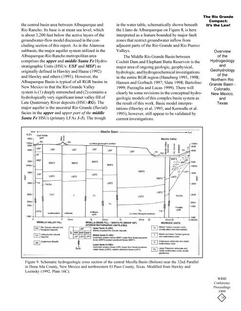
<strong>the</strong> central basin area between Albuquerque and<strong>Rio</strong> Rancho. Its base is at mean sea level, whichis about 3,200 feet below <strong>the</strong> active layers <strong>of</strong> <strong>the</strong>groundwater-flow model discussed in <strong>the</strong> concludingsection <strong>of</strong> this report. As in <strong>the</strong> Alamosasubbasin, <strong>the</strong> major aquifer system utilized in <strong>the</strong>Albuquerque-<strong>Rio</strong> Rancho metropolitan areacomprises <strong>the</strong> upper and middle Santa Fe HydrostratigraphicUnits (HSUs: USF and MSF) asoriginally defined in Hawley and Haase (1992)and Hawley and o<strong>the</strong>rs (1995). However, <strong>the</strong>Albuquerque <strong>Basin</strong> is typical <strong>of</strong> all RGR basins inNew Mexico in that <strong>the</strong> <strong>Rio</strong> <strong>Grande</strong> Valleysystem is (1) deeply entrenched and (2) contains ahydrologically very significant inner valley fill <strong>of</strong>Late Quaternary River deposits (HSU-RG). Themajor aquifer is <strong>the</strong> ancestral <strong>Rio</strong> <strong>Grande</strong> (fluvial)facies in <strong>the</strong> upper and upper part <strong>of</strong> <strong>the</strong> middleSanta Fe HSUs (primary LFAs 1-3). The troughin <strong>the</strong> water table, schematically shown beneath<strong>the</strong> Llano de Alburquerque on Figure 8, is hereinterpreted as a feature bounded by major faultzones that restrict groundwater inflow fromadjacent parts <strong>of</strong> <strong>the</strong> <strong>Rio</strong> <strong>Grande</strong> and <strong>Rio</strong> PuercoValleys.The Middle <strong>Rio</strong> <strong>Grande</strong> <strong>Basin</strong> betweenCochiti Dam and Elephant Butte Reservoir is <strong>the</strong>major area <strong>of</strong> ongoing geologic, geophysical,hydrologic, and hydrogeochemical investigationsin <strong>the</strong> entire RGR region (Haneberg 1995, 1998;Hansen and Gorbach 1997; Slate 1998; Bartolino1999; Pazzaglia and Lucas 1999). There willclearly be some revisions in <strong>the</strong> conceptual hydrogeologicmodels <strong>of</strong> this complex basin system as<strong>the</strong> result <strong>of</strong> this work. Basic model interpretations(Hawley et al. 1995, and Kernodle et al.1995), however, still appear to be validated bycurrent investigations.The <strong>Rio</strong> <strong>Grande</strong>Compact:It’s <strong>the</strong> Law!<strong>Overview</strong><strong>of</strong> <strong>the</strong>HydrogeologyandGeohydrology<strong>of</strong> <strong>the</strong>Nor<strong>the</strong>rn <strong>Rio</strong><strong>Grande</strong> <strong>Basin</strong> -Colorado,New Mexico,andTexasFigure 9. Schematic hydrogeologic cross section <strong>of</strong> <strong>the</strong> central Mesilla <strong>Basin</strong> (Bolson) near <strong>the</strong> 32nd Parallelin Dona Aña County, New Mexico and northwestern El Paso County, Texas. Modified from Hawley andLozinsky (1992, Plate 16C).WRRIConferenceProceedings199914
Figure 9 is a schematic hydrogeologic crosssection<strong>of</strong> <strong>the</strong> south-central Mesilla <strong>Basin</strong>, whichis approximately aligned along <strong>the</strong> 32 nd Parallel.The section is based on (1) geologic mapping,primarily by Seager and o<strong>the</strong>rs (1987), and (2)subsurface geophysical, hydrogeologic, andwater-quality information collected by Hawleyand Lozinsky (1992). Major contributors to <strong>the</strong>hydrogeologic interpretations shown in Figure 9include Leggat and o<strong>the</strong>rs (1962), Cliett (1969),Hawley and o<strong>the</strong>rs (1969), King and o<strong>the</strong>rs(1971), Gile and o<strong>the</strong>rs (1981), Wilson and o<strong>the</strong>rs(1981), Peterson and o<strong>the</strong>rs (1984), Seager ando<strong>the</strong>rs (1987), and Ken Stevens (USGS-WRDunpublished).The distinctive feature <strong>of</strong> <strong>the</strong> rift-basin-fillsequence in <strong>the</strong> Mesilla <strong>Basin</strong> is that it is relativelythin in comparison to <strong>the</strong> Albuquerque andSan Luis basins, with a saturated thickness <strong>of</strong> nomore than 3,000 ft. As in basin areas to <strong>the</strong> northand <strong>the</strong> Hueco Bolson to <strong>the</strong> sou<strong>the</strong>ast, <strong>the</strong> mostproductive and thickest aquifers are ancestral <strong>Rio</strong><strong>Grande</strong> fluvial deposits (LFAs 1 and 2) <strong>of</strong> <strong>the</strong>upper Santa Fe HSU (USF2). However, <strong>the</strong>seunits are only saturated in <strong>the</strong> nor<strong>the</strong>astern part <strong>of</strong><strong>the</strong> basin near Las Cruces (Hawley and Lozinsky1992). In <strong>the</strong> sou<strong>the</strong>rn and western part <strong>of</strong> <strong>the</strong>basin <strong>the</strong> upper Santa Fe HSU is entirely in <strong>the</strong>vadose zone, and <strong>the</strong> most productive aquiferscomprise <strong>the</strong> middle and lower Santa Fe HSUs(MSF2/LSF2: LFAs 3 and 4). A particularlyproductive aquifer is <strong>the</strong> “deep aquifer”<strong>of</strong> Leggatand o<strong>the</strong>rs (1962), which underlies <strong>the</strong> sou<strong>the</strong>rnMesilla Valley in <strong>the</strong> Anthony-Canutillo area(HSU LSF 2, Figure 9). This unit includes adistinctive eolian sand facies (LFA 4) that intertonguesmountainward with piedmont fanglomerates(LFAs 7-8), and basinward with basinfloorfacies assemblages LFAs (3, 9 and 10?). Thelatter facies are here interpreted as fluvial-deltaicplaya/lakedeposits (Table 1, Figure 5).GROUNDWATER FLOW MODELSIntroduction<strong>Groundwater</strong>-flow models are a numericalway (just one) to merge hydrogeology and geohydrologyto produce a link between cause, process,and effect. The intention is an attempt to predict<strong>the</strong> future or to test <strong>the</strong> validity <strong>of</strong> <strong>the</strong> conceptualmodel <strong>of</strong> <strong>the</strong> groundwater system. In so doing,<strong>the</strong> usual approach is to replicate as closely aspossible every internal condition and outsideinfluence that can affect groundwater flow levels(heads). Even so, <strong>the</strong> title <strong>of</strong> Knoikow andBredehoeft’s 1992 article says it all: “<strong>Groundwater</strong>models cannot be validated.” Modeling isan ever-evolving and ever-learning iterativeprocess as more knowledge <strong>of</strong> <strong>the</strong> system isgained and incorporated. Improvements in scienceand technology will always be necessary forproper utilization <strong>of</strong> this new knowledge base.Models <strong>of</strong> groundwater flow in <strong>the</strong> <strong>Rio</strong><strong>Grande</strong> <strong>Basin</strong> aquifer system first need to beexamined in terms <strong>of</strong> <strong>the</strong> hydrogeologic constraintsplaced on flow regimes by structuralboundary,lith<strong>of</strong>acies, and hydrostratigraphicconditions that are ei<strong>the</strong>r well documented orreasonably inferred (Table 4). Kernodle’s (1992)critique <strong>of</strong> “U.S. Geological Survey Ground-Water-Flow Models <strong>of</strong> <strong>Basin</strong>-Fill Aquifers in <strong>the</strong>Southwestern Alluvial basins region” sets <strong>the</strong> tonefor this paper. “As a rule identifiable geologicfeatures that affect groundwater-flow paths,including geologic structure and lithology <strong>of</strong> beds,need to be represented in <strong>the</strong> model (p.65)”; andmajor categories <strong>of</strong> geohydrologic boundaries inalluvial basins include: “1) internal boundariesthat alter flow paths, including small-permeabilitybeds, fissure-flow volcanics and faults; 2) rechargeboundaries, primarily around <strong>the</strong> perimeter<strong>of</strong> basins (mountain-front recharge), and along <strong>the</strong>channels <strong>of</strong> intermittent streams, arroyos, andwashes (tributary recharge); [and] 3) recharge anddischarge boundaries associated with semipermanentsurface-water systems in <strong>the</strong> flood plains <strong>of</strong>major streams ... (p. 66)”. Finally, “althoughtwo-dimensional models may successfully reproduceselected responses <strong>of</strong> <strong>the</strong> aquifer, <strong>the</strong>y fail toaccurately mimic <strong>the</strong> function <strong>of</strong> <strong>the</strong> system (p.59)”. In comparison ... three-dimensional modelsmore accurately portray <strong>the</strong> flow system in basinfill[aquifers] by simulating <strong>the</strong> vertical component<strong>of</strong> flow. However, <strong>the</strong> worth <strong>of</strong> <strong>the</strong> model isstill a function <strong>of</strong> <strong>the</strong> accuracy <strong>of</strong> <strong>the</strong> hydrologist’sconcept <strong>of</strong> <strong>the</strong> workings <strong>of</strong> <strong>the</strong> aquifer system (p.59).”The <strong>Rio</strong> <strong>Grande</strong>Compact:It’s <strong>the</strong> Law!<strong>Overview</strong><strong>of</strong> <strong>the</strong>HydrogeologyandGeohydrology<strong>of</strong> <strong>the</strong>Nor<strong>the</strong>rn <strong>Rio</strong><strong>Grande</strong> <strong>Basin</strong> -Colorado,New Mexico,andTexasWRRIConferenceProceedings199915