
You also want an ePaper? Increase the reach of your titles
YUMPU automatically turns print PDFs into web optimized ePapers that Google loves.
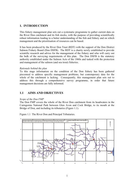
1. INTRODUCTIONThis fishery management plan sets out a systematic programme to gather current data onthe River <strong>Don</strong> catchment and its fish stocks, with the purpose of providing scientificallyrobust information leading to a better understanding of the fish and fishery and on whichmanagement and the prioritisation of resources can be based.It has been produced by the River <strong>Don</strong> Trust (RDT) with the support of the <strong>Don</strong> DistrictSalmon <strong>Fishery</strong> Board (<strong>Don</strong> DSFB). The RDT is a charity newly established to providescientific research and advice for the management of the fishery and who will carry outthe bulk of the surveying requirements of this plan. The <strong>Don</strong> DSFB is the statutoryauthority established under the Salmon Acts of the 1860s and tasked with the protectionand management of the salmon (and sea trout) fisheries.Rationale behind the planTo this stage information on the condition of the <strong>Don</strong> fishery has been gatheredpiecemeal to address specific management problems, but contemporary data for thewhole of the catchment is lacking. Consequently, this management plan sets out toaddress this through a comprehensive survey programme, in order that futuremanagement decisions are fully informed.1.1 AIMS AND OBJECTIVESScope of the <strong>Don</strong> FMPThe <strong>Don</strong> FMP covers the whole of the River <strong>Don</strong> catchment from its headwaters in theCairngorms National Park between Glen Avon and Cock Bridge, to its mouth at theBridge of <strong>Don</strong>, and including its tributaries (Figure 1.1).Figure 1.1 The River <strong>Don</strong> and Principal Tributaries.40Includes material based on Ordnance Survey 1:50,000 maps with the permission of the controller of HIncludes material based on spatial digital data from the Centre for Ecology and Hydrology. Copyrigh.er Majesty’s Stationery Office. Crown copyright.t CEH.N30River Urie2010Allt nanAigheanMeoirVeannaichWater ofNochtyErnanWaterCock BurnWater ofBuchatStrathdonConrieWaterBurn ofTornahaishKindieBurnNeweWater ofCarvieMossat BurnDeskry WaterTowieBurnGadie Burn800310 20 30 40 50 60 70 80 90EssetBurnAlfordLeochelBurnTough BurnTon BurnHervieBurnInverurieElrick BurnAberdeen1