You also want an ePaper? Increase the reach of your titles
YUMPU automatically turns print PDFs into web optimized ePapers that Google loves.
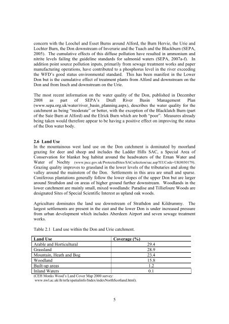
concern with the Leochel and Esset Burns around Alford, the Burn Hervie, the Urie andLochter Burn, the <strong>Don</strong> downstream of Inverurie and the Tuach and the Blackburn (SEPA,2005). The cumulative effects of this diffuse pollution have resulted in ammonium andnitrite levels failing the guideline standards for salmonid waters (SEPA, 2007a-f). Inaddition point source pollution inputs, primarily from sewage treatment works and papermanufacturing operations, have contributed to a phosphorus level in the river exceedingthe WFD’s good status environmental standard. This has been manifest in the Lower<strong>Don</strong> but is the cumulative effect of treatment plants from Alford and downstream on the<strong>Don</strong> and from Insch and downstream on the Urie.The most recent information on the water quality of the <strong>Don</strong>, published in December2008 as part of SEPA’s Draft River Basin <strong>Management</strong> <strong>Plan</strong>(www.sepa.org.uk/water/river_basin_planning.aspx), describes the water quality for thecatchment as being “moderate” or better, with the exception of the Blacklatch Burn (partof the Suie Burn at Alford) and the Elrick Burn which are both “poor”. Measures alreadybeing taken would therefore appear to be having a positive effect on improving the statusof the <strong>Don</strong> water body.2.6 Land UseIn the mountainous west land use on the <strong>Don</strong> catchment is dominated by moorlandgrazing for deer and sheep and includes the Ladder Hills SAC, a Special Area ofConservation for blanket bog habitat around the headwaters of the Ernan Water andWater of Nochty (www.jncc.gov.uk/ProtectedSites/SACselection/sac.asp?EUCode=UK0030179).Grazing quality improves to grassland in the lower levels of the tributaries and along thevalley around the mainstem of the <strong>Don</strong>. Settlements in this area are small and sparse.Coniferous plantations generally follow the lower slopes of the upper <strong>Don</strong> but are largeraround Strathdon and on areas of higher ground further downstream. Woodlands in thelower catchment are mainly small, mixed woodlands: Paradise and Tilliefoure Woods aredesignated Sites of Special Scientific Interest as upland oak woods.Agriculture dominates the land use downstream of Strathdon and Kildrummy. Thelargest settlements are present in the east and the lower <strong>Don</strong> is under increased pressurefrom urban development which includes Aberdeen Airport and seven sewage treatmentworks.Table 2.1 Land use within the <strong>Don</strong> and Urie catchment.Land Use Coverage (%)Arable and Horticultural 29.4Grassland 28.9Mountain, Heath and Bog 23.4Woodland 15.8Built-up areas 1.2Inland Waters 0.1(CEH Monks Wood’s Land Cover Map 2000 survey:www.nwl.ac.uk/ih/nrfa/spatialinfo/Index/indexNorthScotland.html).5


