Comparative analysis of Maritime Spatial Planning ... - Seanergy 2020
Comparative analysis of Maritime Spatial Planning ... - Seanergy 2020
Comparative analysis of Maritime Spatial Planning ... - Seanergy 2020

You also want an ePaper? Increase the reach of your titles
YUMPU automatically turns print PDFs into web optimized ePapers that Google loves.
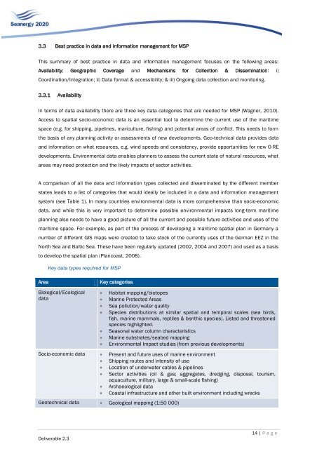
3.3 Best practice in data and information management for MSPThis summary <strong>of</strong> best practice in data and information management focuses on the following areas:Availability; Geographic Coverage and Mechanisms for Collection & Dissemination: i)Coordination/Integration; ii) Data format & accessibility; & iii) Ongoing data collection and monitoring.3.3.1 AvailabilityIn terms <strong>of</strong> data availability there are three key data categories that are needed for MSP (Wagner, 2010).Access to spatial socio-economic data is an essential tool to determine the current use <strong>of</strong> the maritimespace (e.g. for shipping, pipelines, mariculture, fishing) and potential areas <strong>of</strong> conflict. This needs to formthe basis <strong>of</strong> any planning activity or assessments <strong>of</strong> new developments. Geo-technical data provides dataand information on what resources, e.g. wind speeds and consistency, provide opportunities for new O-REdevelopments. Environmental data enables planners to assess the current state <strong>of</strong> natural resources, whatareas may need protection and the likely impacts <strong>of</strong> sector activities.A comparison <strong>of</strong> all the data and information types collected and disseminated by the different memberstates leads to a list <strong>of</strong> categories that would ideally be included in a data and information managementsystem (see Table 1). In many countries environmental data is more comprehensive than socio-economicdata, and while this is very important to determine possible environmental impacts long-term maritimeplanning also needs to have a good picture <strong>of</strong> all the current and possible future activities and uses <strong>of</strong> themaritime space. For example, as part <strong>of</strong> the process <strong>of</strong> developing a maritime spatial plan in Germany anumber <strong>of</strong> different GIS maps were created to take stock <strong>of</strong> the currently uses <strong>of</strong> the German EEZ in theNorth Sea and Baltic Sea. These have been regularly updated (2002, 2004 and 2007) and used as a basisto develop the spatial plan (Plancoast, 2008).Key data types required for MSPAreaKey categoriesBiological/EcologicaldataHabitat mapping/biotopesMarine Protected AreasSea pollution/water qualitySpecies distributions at similar spatial and temporal scales (sea birds,fish, marine mammals, reptiles & benthic species). Listed and threatenedspecies highlighted.Seasonal water column characteristicsMarine substrates/seabed mappingEnvironmental Impact studies (from previous developments)Socio-economic data Present and future uses <strong>of</strong> marine environment Shipping routes and intensity <strong>of</strong> use Location <strong>of</strong> underwater cables & pipelines Sector activities (oil & gas; aggregates, dredging, disposal, tourism,aquaculture, military, large & small-scale fishing) Archaeological data Coastal infrastructure and other built environment including wrecksGeotechnical data Geological mapping (1:50 000)Deliverable 2.314 | P a g e