AOS 452 Lab 1: UNIX and the WEATHER program - Marrella
AOS 452 Lab 1: UNIX and the WEATHER program - Marrella
AOS 452 Lab 1: UNIX and the WEATHER program - Marrella

Create successful ePaper yourself
Turn your PDF publications into a flip-book with our unique Google optimized e-Paper software.
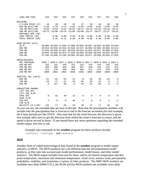
1000-500 THCK 554 553 552 547 549 554 557 557 5587MOISTURE2 M DEW POINT (F) 48 49 49 42 37 40 40 38 38850 MB DP(C)/RH -3/50 1/79 1/74 -1/65 -2/63 0/68 0/62 -2/55 -5/45700 MB DP(C)/RH -9/59 -3/94 -5/84 -15/52 -18/37 -23/18 -24/15 -23/16 -23/14500 MB DP(C)/RH -19/72 -13/98 -19/76 -51/04 -42/08 -23/47 -26/27 -27/27 -33/15PRCPABLE WTR (IN)CONV PRECIP (IN) 0.00 0.00 0.00 0.00 0.00 0.00 0.00 0.00TOTAL PRECIP (IN) 0.10 0.11 0.00 0.00 0.00 0.00 0.00 0.00WIND DD/FFF (Kts)10 M 29/006 29/005 27/006 27/008 29/005 33/007 18/003 16/005 15/004850 MB 28/014 30/010 32/016 32/020 32/017 33/008 25/002 16/006 15/014700 MB 27/033 25/030 27/027 30/018 30/022 31/023 33/017 25/008 27/016500 MB 26/051 25/066 25/073 27/049 30/068 29/054 28/048 29/034 28/027250 MB 27/106 24/096 24/100 26/083 30/083 29/077 29/060 28/040 27/035PRESS/HEIGHTSMSL PRESSURE 1020.7 1020.5 1017.1 1019.2 1020.9 1021.1 1020.0 1022.2 1024.1850 MB HGT 152 152 150 151 152 154 154 155 155700 MB HGT 309 308 305 306 307 309 310 312 313500 MB HGT 571 570 566 563 566 571 574 576 578250 MB HGT 1060 1062 1054 1048 1055 1062 1066 1068 1069VERTICAL VEL (uB/S)850 MB -21 -52 -44 -12 -8 -10 28 -23 4700 MB -10 -17 -37 -18 -20 -38 -14 -5 3500 MB -3 117 56 -3 -49 -21 -25 8 -4CONVECTION PARAMSLIFT INX SFCLIFT INX 4LYRCAPE SFC 0 31 44 12 0 0 0 0 0CAPE 4LYRCIN SFC 2 -6 -5 -40 -1 0 0 1 -1CIN 4LYRHELICITY (0-3 KM) 135 17 -65 23 49 27 17 46 82As you can see, <strong>the</strong> extended data are easy to decode. Note that <strong>the</strong> precipitation numbers willinclude only <strong>the</strong> precipitation that is forecast to fall in <strong>the</strong> forecast increment (for this example,<strong>the</strong> 6 hour period) just like FOUS. Also note that for <strong>the</strong> wind forecast, <strong>the</strong> direction is givenfirst (simply add a zero to get <strong>the</strong> direction from which <strong>the</strong> wind is forecast to come), <strong>and</strong> <strong>the</strong>speed is given second in knots. If you should have any more questions regarding <strong>the</strong> extendedmodel output, feel free to ask.MOSExample sub-comm<strong>and</strong>s in <strong>the</strong> wea<strong>the</strong>r <strong>program</strong> for <strong>the</strong>se products include/extavn, /extngm, <strong>and</strong> /exteta.Ano<strong>the</strong>r form of coded meteorological data found in <strong>the</strong> wea<strong>the</strong>r <strong>program</strong> is model outputstatistics, or MOS. The MOS products are a bit different than <strong>the</strong> aforementioned modelproducts, as <strong>the</strong>y take into account past model performance, model biases, <strong>and</strong> o<strong>the</strong>r modelstatistics. The MOS output includes forecasts for three- <strong>and</strong>/or six-hourly temperature <strong>and</strong> dewpoint temperature, maximum <strong>and</strong> minimum temperature, cloud cover, surface wind, precipitationprobability, visibility, <strong>and</strong> sometimes a variety of o<strong>the</strong>r products. The MRF MOS numbers areavailable once daily (0000 UTC), <strong>the</strong> NGM <strong>and</strong> Eta MOS numbers are available twice daily