Washington Street West watershed - City of Champaign
Washington Street West watershed - City of Champaign
Washington Street West watershed - City of Champaign
- No tags were found...

You also want an ePaper? Increase the reach of your titles
YUMPU automatically turns print PDFs into web optimized ePapers that Google loves.
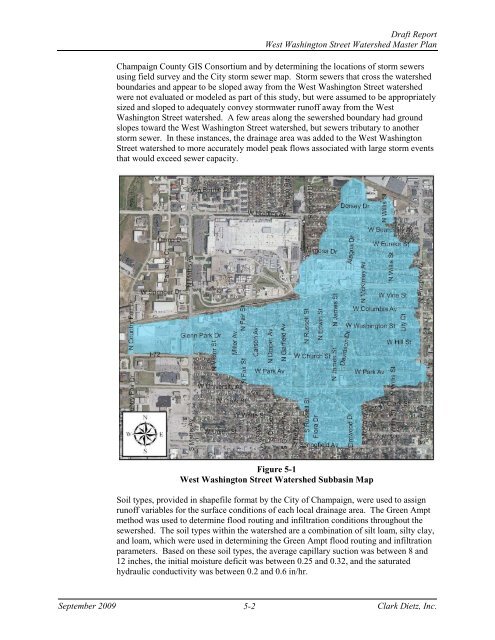
Draft Report<strong>West</strong> <strong>Washington</strong> <strong>Street</strong> Watershed Master Plan<strong>Champaign</strong> County GIS Consortium and by determining the locations <strong>of</strong> storm sewersusing field survey and the <strong>City</strong> storm sewer map. Storm sewers that cross the <strong>watershed</strong>boundaries and appear to be sloped away from the <strong>West</strong> <strong>Washington</strong> <strong>Street</strong> <strong>watershed</strong>were not evaluated or modeled as part <strong>of</strong> this study, but were assumed to be appropriatelysized and sloped to adequately convey stormwater run<strong>of</strong>f away from the <strong>West</strong><strong>Washington</strong> <strong>Street</strong> <strong>watershed</strong>. A few areas along the sewershed boundary had groundslopes toward the <strong>West</strong> <strong>Washington</strong> <strong>Street</strong> <strong>watershed</strong>, but sewers tributary to anotherstorm sewer. In these instances, the drainage area was added to the <strong>West</strong> <strong>Washington</strong><strong>Street</strong> <strong>watershed</strong> to more accurately model peak flows associated with large storm eventsthat would exceed sewer capacity.Figure 5-1<strong>West</strong> <strong>Washington</strong> <strong>Street</strong> Watershed Subbasin MapSoil types, provided in shapefile format by the <strong>City</strong> <strong>of</strong> <strong>Champaign</strong>, were used to assignrun<strong>of</strong>f variables for the surface conditions <strong>of</strong> each local drainage area. The Green Amptmethod was used to determine flood routing and infiltration conditions throughout thesewershed. The soil types within the <strong>watershed</strong> are a combination <strong>of</strong> silt loam, silty clay,and loam, which were used in determining the Green Ampt flood routing and infiltrationparameters. Based on these soil types, the average capillary suction was between 8 and12 inches, the initial moisture deficit was between 0.25 and 0.32, and the saturatedhydraulic conductivity was between 0.2 and 0.6 in/hr.September 20095-2Clark Dietz, Inc.