Washington Street West watershed - City of Champaign
Washington Street West watershed - City of Champaign
Washington Street West watershed - City of Champaign
- No tags were found...

You also want an ePaper? Increase the reach of your titles
YUMPU automatically turns print PDFs into web optimized ePapers that Google loves.
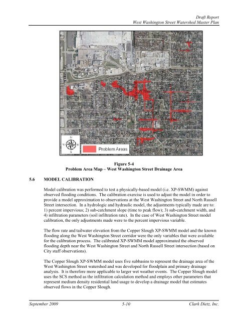
Draft Report<strong>West</strong> <strong>Washington</strong> <strong>Street</strong> Watershed Master Plan5.6 MODEL CALIBRATIONFigure 5-4Problem Area Map – <strong>West</strong> <strong>Washington</strong> <strong>Street</strong> Drainage AreaModel calibration was performed to test a physically-based model (i.e. XP-SWMM) againstobserved flooding conditions. The calibration exercise is used to adjust the model in order toprovide a model approximation to observations at the <strong>West</strong> <strong>Washington</strong> <strong>Street</strong> and North Russell<strong>Street</strong> intersection. In a hydrologic and hydraulic model, the adjustments typically made are to:1) percent impervious; 2) sub-catchment slope (time to peak flow); 3) sub-catchment width, and4) infiltration parameters (soil infiltration rate). In the case <strong>of</strong> <strong>West</strong> <strong>Washington</strong> <strong>Street</strong> modelcalibration, the only adjustments made were to the percent impervious variable.The flow rate and tailwater elevation from the Copper Slough XP-SWMM model and the knownflooding along the <strong>West</strong> <strong>Washington</strong> <strong>Street</strong> corridor were the only variables that were availablefor the calibration process. The calibrated XP-SWMM model approximated the observedflooding depth near the <strong>West</strong> <strong>Washington</strong> <strong>Street</strong> and North Russell <strong>Street</strong> intersection (based on<strong>City</strong> staff observations).The Copper Slough XP-SWMM model uses five subbasins to represent the drainage area <strong>of</strong> the<strong>West</strong> <strong>Washington</strong> <strong>Street</strong> <strong>watershed</strong> and was developed for floodplain and primary drainageanalysis. It is therefore more applicable to larger wet weather events. The Copper Slough modeluses the SCS method as the infiltration calculation method and employs other parameters thatrepresent medium density residential land usage to develop a drainage model that estimatesobserved flows in the Copper Slough.September 20095-10Clark Dietz, Inc.