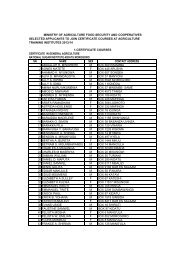
ASDP: Environmental And Social Management Framework
ASDP: Environmental And Social Management Framework
ASDP: Environmental And Social Management Framework
- No tags were found...

Create successful ePaper yourself
Turn your PDF publications into a flip-book with our unique Google optimized e-Paper software.
efore joining the Kisigo at Mtera. It then flows westward through the Ruaha Gorge intoKilombero plains before joining the Rufiji.Kilombero RiverThe Kilombero is 39,990 km 2 about 23% of the total area, but contributes about 65% of theflow to the Rufiji. An important features of the Kilombero basin is the great fertile Kilomberovalley below the eastern scarp of the Udzungwa mountains. Numerous rivers flow on thescarp from the Udzungwa plateau. Some of the important rivers are Ruhudji, Kihansi,Luhombero, Kigogo-Ruaha and Mpanga. The Ruhudji and the Luhombero form theKilombero river. After Shughuri rapids on the old basement step, the Kilombero joins theLuwegu flowing from south east to form the Rufiji. Mean flow of some of the Rivers in theKilombero are as follows:The Rufiji basin is large, with differing rainfall and catchment characteristics. The areanorth of Poroto and Udzungwa Mountain is under semi-arid conditions with mean annualrainfall of 500 mm. Rainfall increases southward and larger falls of 1800 mm per year areobserved on the slopes at the Udzungwa and Kipengere range. The rainfall pattern is suchthat there is one rainy season (mid-November to May) and one dry season. This pattern isthe same all over the basin with the exception of coastal areas where there is slighttendency to bimodal rain pattern. There is a tendency for the dry season to set earlier inthe Great Ruaha basin than the Kilombero basin. The Kilombero floods occur at the end ofApril or the beginning of May.Runoff pattern is closely related to the rainfall pattern. Rivers start rising in December witha peak in March-April.Ruvuma River and Southern CoastIn this basin, independent river systems drain into the Indian Ocean, the major riversystems are: River Matandu, River Mavuji, River Mbwemkuru, River Lukuledi, RiversMambi and Mbuo River Ruvuma. The dominant features are the Makonde and Rondoplateaux separated by the Lukuledi valley. Except for these raised plateaux, the land risesgradually from the Indian Ocean to the hinterland. A large part of the area of the Matandu,Mavuji, Mbwemkuru, Lukuledi, Mambi and Mbuo rivers lie at or below 500 metres abovemean sea level.The Ruvuma is shared by Tanzania and Mozambique and forms almost the entireTanzania and Mozambique boarder. A large portion of the Ruvuma river is in theMozambique. Several large tributaries originate in Tanzania in Mbinga, Songea, Tunduruand Masasi districts. The total basin area on the Tanzanian side is about 104,000kmk 2 .The mean temperature in the coastal area is 26 o C and that of the hinterland is 24 o C. Theannual and daily variations in the temperature are small.The rainfall pattern is such that there is one dry season June to November and the wet orrainy season the rest of the year. This pattern is very regular. The annual mean rainfall is800 to 1200mm recorded on the Rondo and Makonde plateaux and in the Matengohighlands while elsewhere rainfall is between 800 - 1000m. The year to year variation inrainfall is very high. The annual precipitation may rise up to 2,000mm once in twenty yearsand may fall to 500mm once in twenty years in places where the mean annual rainfall is1000mm per year. Rainfall as low as 200mm have been recorded at Mtwara and Lindi.23/114