mechanisms of slope failure in volcanic soils during earthquakes
mechanisms of slope failure in volcanic soils during earthquakes
mechanisms of slope failure in volcanic soils during earthquakes

You also want an ePaper? Increase the reach of your titles
YUMPU automatically turns print PDFs into web optimized ePapers that Google loves.
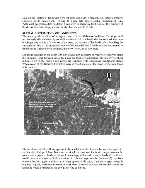
Data on the location <strong>of</strong> landslides were collected us<strong>in</strong>g SPOT monospectral satellite imagerycollected on 28 January 2001 (figure 3). These data have a spatial resolution <strong>of</strong> 10m.Additional geographic data on debris flows were collected by field survey. The majority <strong>of</strong>the debris flows was large, and was easily observed on SPOT data.SPATIAL DISTRIBUTION OF LANDSLIDESThe majority <strong>of</strong> landslides <strong>of</strong> all types occurred <strong>in</strong> the Balsamo Cordillera. The ridge itselfwas strongly affected either by rockfall and debris fall type landslides that resulted <strong>in</strong> seriousblockages due to loss <strong>of</strong> a section <strong>of</strong> the road, or, because <strong>of</strong> landslide debris block<strong>in</strong>g thecarriageway. Due to the metastable nature <strong>of</strong> the material that failed it, was not uncommon t<strong>of</strong><strong>in</strong>d the road surface buried <strong>in</strong> approximately 0.1 to 0.2 m <strong>of</strong> silty sand.Landslide densities <strong>in</strong> the order 100-200 <strong>failure</strong>s per kilometre <strong>of</strong> road were observed alongthe Balsamo Ridge between Santa Tecla and the town <strong>of</strong> Comosagua. The majority <strong>of</strong> these<strong>failure</strong>s were <strong>of</strong> the rockfall and debris fall varieties, with occasional translational slides.Where rocks <strong>of</strong> the Balsamo Formation were exposed at crest <strong>of</strong> the <strong>slope</strong> larger, rock blockfalls occurred.NDendritic dra<strong>in</strong>age patternformed on terra<strong>in</strong> dom<strong>in</strong>atedby the Balsamo FormationThe Balsiamo R dgeLas BarriolerasLas Col<strong>in</strong>asComosaguaFigure 3. SPOT monochromatic image (near <strong>in</strong>fra-red) <strong>of</strong> the area west <strong>of</strong> SanSalvador. Landslides appear as white areas on the image.The <strong>in</strong>cidence <strong>of</strong> debris flows appears to be unrelated to the distance between the epicentreand the site <strong>of</strong> <strong>slope</strong> <strong>failure</strong>. Based on the simple attenuation <strong>of</strong> seismic energy between thesource and a potential landslide, it would seem logical that a decrease <strong>in</strong> landslide <strong>in</strong>cidencewould occur with distance. Such a relationship is <strong>in</strong> fact supported by Bommer [5] who bothobserve that to trigger landslides at a larger epicentral distance, a greater energy release isrequired. Equally therefore, <strong>in</strong> terms <strong>of</strong> work done, it would be expected that the size <strong>of</strong> thelandslide would be related to the energy arriv<strong>in</strong>g at the site.