

Bells Canyon - Utah Geological Survey
Bells Canyon - Utah Geological Survey
Bells Canyon - Utah Geological Survey

Create successful ePaper yourself
Turn your PDF publications into a flip-book with our unique Google optimized e-Paper software.
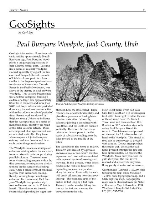
S URVEY N OTES 11GeoSightsby Carl EgePaul Bunyans Woodpile, Juab County, <strong>Utah</strong>Geologic information: Born from volcanicactivity approximately 30 millionyears ago, Paul Bunyans Woodpileis a unique geologic feature inJuab County, central <strong>Utah</strong>. Lookinglike a series of colossal woodpilesstacked up neatly by a giant (in thiscase Paul Bunyan), this site is a relicof <strong>Utah</strong>’s volcanic past. A volcano,similar to the large composite or stratovolcanosof the modern CascadeRange in the Pacific Northwest, wasactive in the vicinity of Paul BunyansWoodpile. This volcano became inactiveand later collapsed, forming acaldera or a large hole approximately8.5 miles in diameter and more than3,000 feet deep. After a brief period ofdormancy, the volcano became activewithin the caldera for a brief period oftime. Recent work conducted byBrigham Young University indicatesthat the Woodpile may be a series ofnumerous dikes, probably the resultof this later volcanic activity. Dikesare composed of an igneous rock andare oriented vertically. They formwhen magma is injected into preexistingcracks or fissures and latercools under the ground surface.View of Paul Bunyans Woodpile (looking northeast)The Woodpile is a classic example ofcolumnar jointing where the rock fracturesin prismatic patterns, producingparallel columns. These columnsform when cooling magma within thedike contracts, forming cracks similarto those on the surface of a coolingcake. Once a crack forms, it continuesto grow from subsurface cooling,thereby forming longer and longercolumns. Each column at Paul BunyansWoodpile is approximately 1foot in diameter and up to 15 feet inlength. The columns are three toseven sided depending on slight variationsin how the lava cooled. Thesecolumns are oriented horizontally andgive the appearance of having beentilted on their sides. Normally,columnar jointing is associated withlava flows, and the joints are orientedvertically. However, the horizontalorientation here appears to be theresult of subsurface cooling from thesides inward to the middle of thedikes.The Woodpile is also home to an arch.This arch was created by a processknown as frost action, which involvesexpansion and contraction associatedwith repeated cycles of freezing andthawing. In this process, water enterscracks in the rock and freezes; theexpanding ice creates separationalong the cracks. Eventually the rockwill break off, creating holes in a rockoutcrop. The estimated span of thearch is 20 feet long by 4 feet high.This arch can be seen by hiking fartherup the trail and viewing theWoodpile from the side.How to get there: From Salt LakeCity, travel south on I-15 to Santaquin(exit 248). Turn right (west) at the endof the off ramp onto U.S. Route 6.Travel west and then south on U.S.Route 6 for 35.7 miles to a sign indicatingPaul Bunyans Woodpileturnoff. Turn left (east) and proceedup the road for 3.2 miles to the trailhead to the Woodpile. This stretch ofroad can be quite rough so proceedwith caution. Do not attempt whenthe road is wet. Once at the trailhead, proceed through the gate andhike approximately 0.5 miles to theWoodpile. Make sure you close thegate after you. The trail is wellmarked and a relatively easy hike.Bring plenty of water and sunscreen.Useful maps: Lynndyl 1:100,000-scaletopographic map, Tintic Mountain1:24,000-scale topographic map, and a<strong>Utah</strong> highway map. Topographicmaps can be obtained from the NaturalResources Map & Bookstore, 1594West North Temple, Salt Lake City,UT, (801) 537-3320.


