4earthquake may be felt within a largearea of northern <strong>Utah</strong>, extendingnorth-south from Ogden to Provo andeast-west from Park City to Tooele.Because of this large area, we willmap earthquake hazards at a scale of1:250,000. Mapped hazards willinclude those mapped for the centralCache Valley, and will be based onsimilar relationships between thenature of geologic materials and theirhistorical response to earthquakeselsewhere. We will also incorporatethe results of previous studies of othergeologic hazards to ensure comprehensiveconsideration of the effects ofimportant hazards in the loss estimation.These other hazards include tectonicsubsidence (tilting of the valleyfloor toward the surface fault rupture),flooding due to dam failure,and flooding due to a seiche (anearthquake ground-shaking-generatedwave causing a sudden rise in waterlevel) in Great Salt Lake.Hazard Maps and Risk ReductionMapping earthquake hazards is aninteresting geological exercise, but themaps have very practical applications.Earthquake-hazard maps focus ourattention on important issues regardingearthquake risk reduction.Earthquake hazards along theWasatch Front are relatively greatbecause of the presence of theWasatch fault zone and other activefaults in the region. However, the distributionof earthquake hazards is notuniform. For example, saturatedflood plains along valley bottoms maypose a high liquefaction hazard but alow hazard for slope failure. Landslidespose a greater hazard on steepvalley and mountain slopes, wherethe potential for liquefaction may benegligible. Earthquake-hazard mapsillustrate the distribution of hazardsbased upon the physical characteristicsof geologic materials.Earthquake risks along the WasatchFront are relatively high because ofthe level of development within seismicallyactive, high-hazard areas.However, the level and age of developmentare also not uniform. Earthquakerisk is greatest where developmentconcentrated in seismically hazardousareas is old and prone toS URVEY N OTESearthquake damage. By mappingearthquake hazards along the WasatchFront in a Geographic InformationSystem, the UGS provides a mechanismfor estimating earthquake risk.This can be analyzed in a GIS by overlayinggeologic-hazard map layerswith relevant building and infrastructureinformation, such as transportationroutes, utilities, and the locationof critical facilities. Analyses can thenbe used to make informed decisionson hazard-reduction and emergencyresponsepolicies, priorities, strategies,and funding levels. Rehabilitatingolder buildings in hazardous areasand applying appropriate seismiccodes to the design and constructionof new buildings can reduce earthquakelosses. Effective planning foremergency response can directresources toward communities mostsubject to risk. The earthquake-hazardmaps show the relative hazard tohelp us prepare for earthquakes priorto their occurrence, rapidly and effectivelyrespond once an earthquakehappens, and improve our understandingof our interaction with thegeologic environment.Geocaching - Treasure hunting with a high-tech twistby Mark MilliganTired of hunting for lost Spanishmines in the Uinta Mountains andfinding nothing but sore feet? Fed upwith panning for gold in the WestDesert and discovering nothing butsand? Ready to give up that metaldetector and your prized pile of rustedtin cans and nails it took you threeweekends under the hot sun touncover? Geocaching may be foryou! New technology has inspired anew breed of weekend treasurehunters - adventurers armed with aGlobal Positioning System (GPS)receiver.Like a scavenger hunt, geocachingentails looking for a cache of hidden“treasure” using a GPS receiver and aprovided set of coordinates. Othergeocachers place all sorts of goodiesin a coffee can, ammunition can, orsimilar container and hide it. Theperson hiding the cache records thesite’s latitude and longitude, thenposts the coordinates on the Internet.Geocaching is a fun way to get outwhile learning and using navigationskills.The Geologic Information and OutreachProgram’s geocacheIn celebration of national Earth ScienceWeek (October 8 - 12) the GeologicInformation and Outreach (GIO)Program will hide a geocache onMonday, October 8. Like others onthe Internet, our geocache has twosimple rules: (1) if you take an item,then you must leave something in itsplace; and (2) record your visit in thecache’s log book. Often caches have atheme. Our theme is minerals androcks (of course) and that is just whatyou will find in the coffee can thatcontains our cache. Not just drivewaygravel, but fun and interestingspecimens (real keepers!). The coordinatesfor our geocache are: N 40°46’ 38.0” and W 111° 56’ 01.2”. (Hint:we did not venture more than a fewblocks from our office.) So jump onthe geocache band wagon and findsome treasure.For other caches and more informationon geocaching, including adviceon setting up your own cache, enterthe key word “geocache” in yourfavorite Internet search engine.
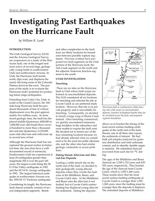
S URVEY N OTES 5Investigating Past Earthquakeson the Hurricane Faultby William R. LundINTRODUCTIONThe <strong>Utah</strong> <strong>Geological</strong> <strong>Survey</strong> (UGS)and the Arizona <strong>Geological</strong> <strong>Survey</strong>are cooperators on a study of the Hurricanefault, one of the longest andmost active of several large, geologicallyyoung faults in southwestern<strong>Utah</strong> and northwestern Arizona. In<strong>Utah</strong>, the Hurricane fault trendsnorth, dips west, and displaces thenearly flat-lying rocks of the ColoradoPlateau down-to-the-west. The purposeof the study is to evaluate theHurricane fault’s potential for producingfuture large earthquakes.Extending from Cedar City, <strong>Utah</strong>, tosouth of the Grand <strong>Canyon</strong>, the 160-mile-long Hurricane fault has producedthousands of feet of verticaldisplacement over the past approximatelyfive million years. In morerecent geologic time, the fault has displacedmiddle Quaternary (600,000 to1,000,000 year old) basalt flows severalhundred to more than a thousandfeet and late Quaternary (