

Bells Canyon - Utah Geological Survey
Bells Canyon - Utah Geological Survey
Bells Canyon - Utah Geological Survey

Create successful ePaper yourself
Turn your PDF publications into a flip-book with our unique Google optimized e-Paper software.
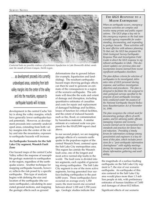
S URVEY N OTES 3Contorted beds are possible evidence of prehistoric liquefaction in Lake Bonneville deltaic sandsnear the mouth of Green <strong>Canyon</strong>, North Logan.. . . as development proceeds into currentlyundeveloped areas, extending from bothvalley margins into the center of the valleyand into the mountains, exposure toearthquake hazards will increase.development in the central Cache Valleyis along the valley margins, whichhave generally lower earthquake-hazardpotentials. However, as developmentproceeds into currently undevelopedareas, extending from both valleymargins into the center of the valleyand into the mountains, exposureto earthquake hazards will increase.An Earthquake Scenario for the SaltLake City segment, Wasatch FaultZoneOur hazard maps of the central CacheValley reflect the response of susceptiblegeologic materials to earthquakesin the region, regardless of the earthquakesource. Another technique formapping earthquake hazards, however,reflects the risk posed by a specificearthquake. This type of analysisbegins with defining the size andlocation of the earthquake (the scenarioearthquake), calculating its associatedground motions, and mappingthe geologic effects such as grounddeformations due to ground failure(for example, liquefaction and landsliding).The resultant earthquakehazardmaps showing geologic effectscan then be used to generate an estimateof the consequences to a regionof the scenario earthquake. The estimatewill describe the scale and extentof damage and disruption, includingquantitative estimates of casualtiesand costs for repair and replacementof damaged buildings and facilities,losses of function for critical facilities,and the extent of induced hazardssuch as fire, flood, or contaminationby hazardous materials. A similarestimate at a national scale was preparedfor the HAZUS99 report citedabove.In our second project, we are mappinggeologic effects of a scenario earthquakein the populous region of thecentral Wasatch Front, centered uponthe Salt Lake City metropolitan area.This region lies astride the Wasatchfault zone, one of the longest andmost active normal-slip faults in theworld. The fault zone is divided intoten segments, each capable of generatingstrong earthquakes. The Salt LakeCity segment is one of the more activesegments, having generated four surface-faultingearthquakes in the past6,000 years. These earthquakes haveoccurred on average every 1,350years; the most recent one occurredbetween about 1,100 and 1,550 yearsago. Geologic studies indicate thatTHE UGS RESPONSE TO AMAJOR EARTHQUAKEWhen an earthquake occurs, emergencyresponseactivities are complex andinvolve many private and public organizations.The UGS plays a key role inthis emergency response as the lead statescientific agency responsible for understanding,documenting, and respondingto geologic hazards. These activities willbe most effective with advance planning.To that end, the UGS has prepared the<strong>Utah</strong> <strong>Geological</strong> <strong>Survey</strong> Earthquake-Response Plan and Investigation FieldGuide to direct the UGS response to significantearthquakes in <strong>Utah</strong>. This documentupdates our previous plan andincorporates lessons learned from recentsignificant earthquakes elsewhere.The plan defines criteria for selection ofearthquakes to be investigated, delineatesroles of UGS personnel duringresponse, and outlines investigationobjectives and procedures. The plan isdesigned to facilitate the role assigned tostate geological surveys specified in theprogram of post-earthquake investigationsconducted under the auspices ofthe National Earthquake Hazard ReductionsReauthorization Act of November16, 1990.The plan recognizes the critical need fordocumenting geologic effects of earthquakes,and for advising public officialsmanaging response and recovery.Lessons learned can be incorporated intostandards and practices for future hazardreduction. Providing a timelyforum for information exchange amonggeoscientists and engineers is a key elementof this plan, which includes provisionsfor a “post-earthquake informationclearinghouse” with nightly meetingsduring the response period to help coordinateinformation gathering and availability.the magnitude of a surface-faultingearthquake on the Salt Lake City segmentis 7, the size of our scenarioearthquake. An earthquake of thissize centered in the Salt Lake Cityarea would place more than 1.3 millionpeople at risk, with preliminaryestimates of human fatalities of 7,600and damages of about $12 billion.Significant effects of our scenario


