- Page 2 and 3:
Table of ContentsSectionPageExecuti
- Page 4 and 5:
Contents (Cont.)BCDEPhotographsTitl
- Page 6 and 7:
• The Subject Site is not listed
- Page 8 and 9:
SIGNIFICANT ASSUMPTIONSCertain sign
- Page 11 and 12:
DESCRIPTION OF STRUCTURES, ROADS, O
- Page 13 and 14:
4 RECORD REVIEWPHYSICAL SETTING SOU
- Page 15 and 16:
National Priorities ListThe Nationa
- Page 17 and 18:
using state funds (state equivalent
- Page 19 and 20:
Table 2.Aerial Photograph ReviewYea
- Page 21 and 22:
5 SITE RECONNAISSANCEMETHODOLOGY AN
- Page 23 and 24:
6 FINDINGS AND OPINIONThe following
- Page 25 and 26:
8 REFERENCESDocumentation of all so
- Page 27 and 28:
10 QUALIFICATIONS OF ENVIRONMENTALP
- Page 29 and 30:
APPENDIX AFigures
- Page 31 and 32:
Site 10Figure 2Source:Site Vicinity
- Page 40:
APPENDIX CTitle Abstract and Enviro
- Page 43 and 44:
EDR Environmental LienSearch Report
- Page 87 and 88:
APPENDIX DEnvironmental Regulatory
- Page 89 and 90:
TABLE OF CONTENTSSECTIONPAGEExecuti
- Page 91 and 92:
EXECUTIVE SUMMARYCORRACTSRCRA-TSDFR
- Page 93 and 94:
EXECUTIVE SUMMARYDue to poor or ina
- Page 95 and 96:
EDR Inc.
- Page 97 and 98:
MAP FINDINGS SUMMARYSearchTarget Di
- Page 99 and 100:
ORPHAN SUMMARYCity EDR ID Site Name
- Page 101 and 102:
GOVERNMENT RECORDS SEARCHED / DATA
- Page 103 and 104:
GOVERNMENT RECORDS SEARCHED / DATA
- Page 105 and 106:
GOVERNMENT RECORDS SEARCHED / DATA
- Page 107 and 108:
GOVERNMENT RECORDS SEARCHED / DATA
- Page 109 and 110:
GOVERNMENT RECORDS SEARCHED / DATA
- Page 111 and 112:
GOVERNMENT RECORDS SEARCHED / DATA
- Page 113 and 114:
GOVERNMENT RECORDS SEARCHED / DATA
- Page 115 and 116:
GOVERNMENT RECORDS SEARCHED / DATA
- Page 117 and 118:
GEOCHECK ® - PHYSICAL SETTING SOUR
- Page 119 and 120:
GEOCHECK ® - PHYSICAL SETTING SOUR
- Page 121 and 122:
GEOCHECK ® - PHYSICAL SETTING SOUR
- Page 123 and 124:
GEOCHECK ® - PHYSICAL SETTING SOUR
- Page 125 and 126:
GEOCHECK ® - PHYSICAL SETTING SOUR
- Page 127 and 128:
GEOCHECK ® - PHYSICAL SETTING SOUR
- Page 129 and 130:
GEOCHECK ® - PHYSICAL SETTING SOUR
- Page 131 and 132:
GEOCHECK ® - PHYSICAL SETTING SOUR
- Page 133 and 134:
GEOCHECK ® - PHYSICAL SETTING SOUR
- Page 135 and 136:
GEOCHECK ® - PHYSICAL SETTING SOUR
- Page 137 and 138:
GEOCHECK ® - PHYSICAL SETTING SOUR
- Page 139 and 140:
GEOCHECK ® - PHYSICAL SETTING SOUR
- Page 141 and 142:
GEOCHECK ® - PHYSICAL SETTING SOUR
- Page 143 and 144:
GEOCHECK ® - PHYSICAL SETTING SOUR
- Page 145 and 146:
GEOCHECK ® - PHYSICAL SETTING SOUR
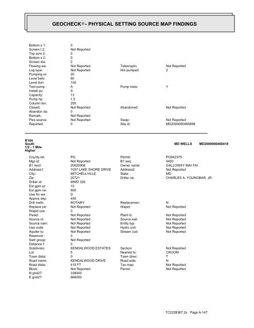
- Page 147 and 148:
GEOCHECK ® - PHYSICAL SETTING SOUR
- Page 149 and 150:
GEOCHECK ® - PHYSICAL SETTING SOUR
- Page 151 and 152:
GEOCHECK ® - PHYSICAL SETTING SOUR
- Page 153 and 154:
GEOCHECK ® - PHYSICAL SETTING SOUR
- Page 155 and 156:
GEOCHECK ® - PHYSICAL SETTING SOUR
- Page 157 and 158:
GEOCHECK ® - PHYSICAL SETTING SOUR
- Page 159 and 160:
GEOCHECK ® - PHYSICAL SETTING SOUR
- Page 161 and 162:
GEOCHECK ® - PHYSICAL SETTING SOUR
- Page 163 and 164:
GEOCHECK ® - PHYSICAL SETTING SOUR
- Page 165 and 166:
GEOCHECK ® - PHYSICAL SETTING SOUR
- Page 167 and 168:
GEOCHECK ® - PHYSICAL SETTING SOUR
- Page 169 and 170:
GEOCHECK ® - PHYSICAL SETTING SOUR
- Page 171 and 172:
GEOCHECK ® - PHYSICAL SETTING SOUR
- Page 173 and 174:
GEOCHECK ® - PHYSICAL SETTING SOUR
- Page 175 and 176:
GEOCHECK ® - PHYSICAL SETTING SOUR
- Page 177 and 178:
GEOCHECK ® - PHYSICAL SETTING SOUR
- Page 179 and 180:
GEOCHECK ® - PHYSICAL SETTING SOUR
- Page 181 and 182:
GEOCHECK ® - PHYSICAL SETTING SOUR
- Page 183 and 184:
GEOCHECK ® - PHYSICAL SETTING SOUR
- Page 185 and 186:
GEOCHECK ® - PHYSICAL SETTING SOUR
- Page 187 and 188:
GEOCHECK ® - PHYSICAL SETTING SOUR
- Page 189 and 190:
GEOCHECK ® - PHYSICAL SETTING SOUR
- Page 191 and 192:
GEOCHECK ® - PHYSICAL SETTING SOUR
- Page 193 and 194:
GEOCHECK ® - PHYSICAL SETTING SOUR
- Page 195 and 196:
GEOCHECK ® - PHYSICAL SETTING SOUR
- Page 197 and 198:
GEOCHECK ® - PHYSICAL SETTING SOUR
- Page 199 and 200:
GEOCHECK ® - PHYSICAL SETTING SOUR
- Page 201 and 202:
GEOCHECK ® - PHYSICAL SETTING SOUR
- Page 203 and 204:
GEOCHECK ® - PHYSICAL SETTING SOUR
- Page 205 and 206:
GEOCHECK ® - PHYSICAL SETTING SOUR
- Page 207 and 208:
GEOCHECK ® - PHYSICAL SETTING SOUR
- Page 209 and 210:
GEOCHECK ® - PHYSICAL SETTING SOUR
- Page 211 and 212: GEOCHECK ® - PHYSICAL SETTING SOUR
- Page 213 and 214: GEOCHECK ® - PHYSICAL SETTING SOUR
- Page 215 and 216: GEOCHECK ® - PHYSICAL SETTING SOUR
- Page 217 and 218: GEOCHECK ® - PHYSICAL SETTING SOUR
- Page 219 and 220: GEOCHECK ® - PHYSICAL SETTING SOUR
- Page 221 and 222: GEOCHECK ® - PHYSICAL SETTING SOUR
- Page 223 and 224: GEOCHECK ® - PHYSICAL SETTING SOUR
- Page 225 and 226: GEOCHECK ® - PHYSICAL SETTING SOUR
- Page 227 and 228: GEOCHECK ® - PHYSICAL SETTING SOUR
- Page 229 and 230: GEOCHECK ® - PHYSICAL SETTING SOUR
- Page 231 and 232: GEOCHECK ® - PHYSICAL SETTING SOUR
- Page 233 and 234: GEOCHECK ® - PHYSICAL SETTING SOUR
- Page 235 and 236: GEOCHECK ® - PHYSICAL SETTING SOUR
- Page 237 and 238: GEOCHECK ® - PHYSICAL SETTING SOUR
- Page 239 and 240: GEOCHECK ® - PHYSICAL SETTING SOUR
- Page 241 and 242: GEOCHECK ® - PHYSICAL SETTING SOUR
- Page 243 and 244: GEOCHECK ® - PHYSICAL SETTING SOUR
- Page 245 and 246: GEOCHECK ® - PHYSICAL SETTING SOUR
- Page 247 and 248: GEOCHECK ® - PHYSICAL SETTING SOUR
- Page 249 and 250: GEOCHECK ® - PHYSICAL SETTING SOUR
- Page 251 and 252: GEOCHECK ® - PHYSICAL SETTING SOUR
- Page 253 and 254: GEOCHECK ® - PHYSICAL SETTING SOUR
- Page 255 and 256: GEOCHECK ® - PHYSICAL SETTING SOUR
- Page 257 and 258: GEOCHECK ® - PHYSICAL SETTING SOUR
- Page 259 and 260: GEOCHECK ® - PHYSICAL SETTING SOUR
- Page 261: GEOCHECK ® - PHYSICAL SETTING SOUR
- Page 265 and 266: GEOCHECK ® - PHYSICAL SETTING SOUR
- Page 267 and 268: GEOCHECK ® - PHYSICAL SETTING SOUR
- Page 269 and 270: GEOCHECK ® - PHYSICAL SETTING SOUR
- Page 271 and 272: GEOCHECK ® - PHYSICAL SETTING SOUR
- Page 273 and 274: GEOCHECK ® - PHYSICAL SETTING SOUR
- Page 275 and 276: GEOCHECK ® - PHYSICAL SETTING SOUR
- Page 277 and 278: PHYSICAL SETTING SOURCE RECORDS SEA
- Page 279 and 280: APPENDIX EHistorical Use Informatio
- Page 281 and 282: EDR Aerial Photo Decade PackageEnvi
- Page 283 and 284: INQUIRY #:YEAR:2228367.51957= 750'
- Page 285 and 286: INQUIRY #:YEAR:2228367.51970= 750'
- Page 287 and 288: INQUIRY #:YEAR:2228367.51988= 750'
- Page 289 and 290: Site 10: Croom Station RoadCroom St
- Page 291 and 292: Historical Topographic MapN→TARGE
- Page 293 and 294: Historical Topographic MapN→TARGE
- Page 295 and 296: Historical Topographic MapN→TARGE
- Page 297 and 298: Historical Topographic MapN→TARGE
- Page 299 and 300: Site 10: Croom Station RoadCroom St


