2 Physical Properties of Marine Sediments - Blogs Unpad
2 Physical Properties of Marine Sediments - Blogs Unpad
2 Physical Properties of Marine Sediments - Blogs Unpad

You also want an ePaper? Increase the reach of your titles
YUMPU automatically turns print PDFs into web optimized ePapers that Google loves.
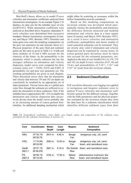
2<strong>Physical</strong> <strong>Properties</strong> <strong>of</strong> <strong>Marine</strong> <strong>Sediments</strong>Biot-Stoll’s theory allows us to model P-wavevelocities and attenuation coefficients analyzed fromtransmission seismograms. As an example Figure 2.16displays six data sets for the turbidite layer <strong>of</strong> coreGeoB1510-2. While attenuation coefficients wereanalyzed as described above frequency dependent P-wave velocities were determined from successivebandpass filtered transmission seismograms (Courtneyand Mayer 1993; Breitzke 1997). Porosities andmean grain sizes enter the modeling computations viathe pore size parameter (a) and structure factor (a’).<strong>Physical</strong> properties <strong>of</strong> the pore fluid and sedimentgrains are the same as given in Table 2.2. A bulk andshear modulus <strong>of</strong> 10 and 6 MPa account for theelasticity <strong>of</strong> the frame. As the permeability is theparameter which is usually unknown but has thestrongest influence on attenuation and velocitydispersion, model curves were computed for threeconstant ratios κ/a 2 = 0.030, 0.010 and 0.003 <strong>of</strong>permeability (κ) and pore size parameter (a). Theresulting permeabilities are given in each diagram.These theoretical curves show that the attenuationand velocity data between 170 and 182 cm depth canconsistently be modeled by an appropriate set <strong>of</strong>input parameters. Viscous losses due to a global porewater flow through the sediment are sufficient to explainthe attenuation in these sediments. Only if theturbidite base is approached (188 - 210 cm depth) theattenuation and velocity dispersion data successivelydeviate from the model curves probably dueto an increasing amount <strong>of</strong> coarse-grained foraminifera.An additional damping mechanism whichmight either be scattering or resonance within thehollow foraminifera must be considered.Based on this modeling computations aninversion scheme was developed which automaticallyiterates the permeability and minimizesthe difference between measured and modeledattenuation and velocity data in a least squaresense (Courtney and Mayer 1993; Breitzke 1997).As a result S-wave velocities and attenuationcoefficients, permeabilities and elastic moduli <strong>of</strong>water-saturated sediments can be estimated. Theyare strictly only valid if attenuation and velocitydispersion can be explained by viscous losses. Incoarse-grained parts deviations must be takeninto account for the estimated parameters, too.Applied to the data <strong>of</strong> core GeoB1510-2 in 170, 176and 182 cm depth S-wave velocities <strong>of</strong> 67, 68 and74 m/s and permeabilities <strong>of</strong> 5·10 -13 , 1·10 -12 and3·10 -12 m 2 result from this inversion scheme.2.5 Sediment ClassificationFull waveform ultrasonic core logging was appliedto terrigenous and biogenic sediment cores toanalyze P-wave velocities and attenuation coefficientstypical for the different settings. Togetherwith the bulk parameters and the physical propertiesestimated by the inversion scheme they formthe data base for a sediment classification whichidentifies different sediment types from theirTable 2.3 Geographical coordinates, water depth, core length, region and composition <strong>of</strong> the sediment coresconsidered for the sediment classification in Section 2.5.Core Coordinates Water Core Region SedimentDepth Length Composition40KL 07°33.1'N 3814 m 8.46 m Bengal terrigenous clay, silt, sand85°29.7'EFan47KL 11°10.9'N 3293 m 10.00 m Bengal terrigenous clay, silt, sand;88°24.9'E Fan foram. and nann<strong>of</strong>ossil oozeGeoB 30°27.1'S 3941 m 8.19 m Rio Grande foram. and nann<strong>of</strong>ossil ooze2821-1 38°48.9'W RisePS 46°56.1'S 4102 m 17.65 m Meteor diatomaceous mud/ooze; few2567-2 06°15.4'E Rise foram. and nann<strong>of</strong>ossil layers52