Embedded Sensing for Standardised Urban Environmental Monitoring
Embedded Sensing for Standardised Urban Environmental Monitoring
Embedded Sensing for Standardised Urban Environmental Monitoring

Create successful ePaper yourself
Turn your PDF publications into a flip-book with our unique Google optimized e-Paper software.
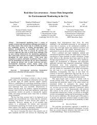
A. Usage of Open StandardsThe components of this process chain are separated byseveral interfaces, which are defined using open standards.The first central group of standards is subsumed under theterm Sensor Web Enablement (SWE), an initiative by theOGC that aims to make sensors discoverable, query-able,and controllable over the Internet [16]. Currently, the SWEfamily consists of seven standards, which encompass theentire process chain from making sensors discoverable in aregistry, to measuring physical phenomena, and sending outalerts. [17]• Sensor Model Language (SensorML) – This standardprovides an XML schema <strong>for</strong> defining thegeometric, dynamic and observational characteristicsof a sensor. Thus, SensorML assists in the discoveryof different types of sensors, and supports theprocessing and analysis of the retrieved data, as wellas the geo-location and tasking of sensors.• Observations & Measurements (O&M) – O&Mprovides a description of sensor observations in the<strong>for</strong>m of general models and XML encodings. Thisframework labels several terms <strong>for</strong> themeasurements themselves as well as <strong>for</strong> therelationship between them. Measurement results areexpressed as quantities, categories, temporal orgeometrical values as well as arrays or composites ofthese.• Transducer Model Language (TML) – Generallyspeaking, TML can be understood as O&M’spendant or streaming data by providing a methodand message <strong>for</strong>mat describing how to interpret rawtransducer data.• Sensor Observation Service (SOS) – SOS provides astandardised web service interface allowing access tosensor observations and plat<strong>for</strong>m descriptions.• Sensor Planning Service (SPS) – SPS offers aninterface <strong>for</strong> planning an observation query. Ineffect, the service per<strong>for</strong>ms a feasibility check duringthe set up of a request <strong>for</strong> data from several sensors.• Sensor Alert Service (SAS) – SAS can be seen as anevent-processing engine whose purpose is to identifypre-defined events such as the particularities ofsensor measurements, and then generate and sendalerts in a standardised protocol <strong>for</strong>mat.• Web Notification Service (WNS) – The WebNotification Service is responsible <strong>for</strong> deliveringgenerated alerts to end-users by E-mail, over HTTP,or via SMS. Moreover, the standard provides anopen interface <strong>for</strong> services, through which a clientmay exchange asynchronous messages with one ormore other services.Furthermore, Sensor Web Registries play an importantrole in sensor network infrastructures. However, they are notdecidedly part of SWE yet, as the legacy OGC CatalogueService <strong>for</strong> Web (CSW) is used. The registry serves tomaintain metadata about sensors and their observations. Inshort, it contains in<strong>for</strong>mation including sensor location,which phenomena they measure, and whether they are staticor mobile. Currently, the OGC is pursuing a harmonisationapproach to integrate the existing CSW into SWE bybuilding profiles in ebRIM/ebXML (e-business RegistryIn<strong>for</strong>mation Model).An important ongoing ef<strong>for</strong>t in SWE development is theestablishment of a central SWE Common specification. Itsgoal is to optimise redundancy and maximise reusability bygrouping common elements <strong>for</strong> several standards under onecentral specification.The functional connections between the describedstandards are illustrated in Fig. 2.Figure 2. Functional Connections between the SWE Standards.Besides these sensor-related standards, other OGCstandards are used <strong>for</strong> data analysis and provisioning. TheWeb Processing Service, as described in [18], provides aninterface to access a processing service offering a number ofpre-defined analytical operations – these can be algorithms,simple calculations, or more complex models, which operateon geospatial data. Both vector and raster data can beprocessed. The output of the processes can be either a predefineddata structure such as Geographic Markup Language(GML), geoRSS, Keyhole Markup Language (KML),Scalable Vector Graphics (SVG), or a web-accessibleresource like a JPEG or PNG picture.<strong>Standardised</strong> raw data access is granted by the use ofOGC WFS, WMS and WCS standards. These well-knownstandards provide access to data in various <strong>for</strong>mats such asvectors (points, lines and polygons), raster images, andcoverages (surface-like structures).More about the described sensor related and dataprovision standards can be found on the OGC web site 1 .B. Location-aware Complex Event ProcessingApart from standardised data transmission and provision,a special focus in the Live Geography approach is theextension of Complex Event Processing (CEP) functionalityby spatial parameters. In a geographic context, CEP can <strong>for</strong>instance serve <strong>for</strong> detecting threshold exceedances, <strong>for</strong> geo-1 http://www.opengeospatial.org