2010 Downtown Plan - Fort Myers Business Development
2010 Downtown Plan - Fort Myers Business Development
2010 Downtown Plan - Fort Myers Business Development

You also want an ePaper? Increase the reach of your titles
YUMPU automatically turns print PDFs into web optimized ePapers that Google loves.
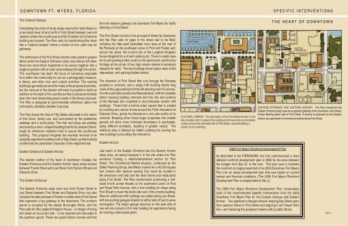
DOWNTOWN FT. MYERS, FLORIDASPECIFIC INTERVENTIONSThe Cultural CampusCompleting the circle of study areas around the Yacht Basin isa two-block sliver of land north of First Street between Lee andJackson where the courthouse and the Chamber of Commercebuilding are located. The <strong>Plan</strong> calls for transforming this blockinto a “cultural campus” where a cluster of civic uses may begathered.The elimination of the First Street diverter (discussed in greaterdetail under the Eastern Entrance study area below) will allowthese two small block fragments to be woven together into asingle long block with an east-west walkway through the center.The courthouse has been the focus of numerous proposalsfrom within the community for use as a photography museum,a library, and other civic and cultural activities. The existingbuilding is generally too small for many of the proposed activities,but the removal of the diverter will make it possible to build anaddition on the back of the courthouse that could accommodateeven the most demanding space needs of the library proposal.The <strong>Plan</strong> is designed to accommodate whichever option thecommunity ultimately decides to pursue.The <strong>Plan</strong> shows the Hall of Fifty States relocated to the centerof this block, facing Lee, and surrounded by the pedestrianwalkway and a small plaza. The Hall and plaza are partiallyenclosed by a new L-shaped building that fronts Jackson Street,ready for whichever institution fails to secure the courthousebuilding. This proposal imagines the eventual removal of anunsightly apartment building north of Bay Street, as that buildingundermines the pedestrian character of the neighborhood.Eastern Entrance & Eastern AnchorThe eastern portion of the heart of downtown includes theEastern Entrance and the Eastern Anchor study areas locatedbetween Fowler Street and Lee Street, from Second Street andEdwards Drive.The Eastern EntranceThe Eastern Entrance study area runs from Fowler Street toLee Street between First Street and Edwards Drive, but alsoincludes the sites just east of Fowler on either side of First Streetthat represent a key gateway to the downtown. The northernparcel is occupied by the stately Burroughs Home, and the<strong>Plan</strong> calls for the Langford Kingston house – in danger of beingtorn down on its current site -- to be restored and relocated tothe southern parcel. These two grand historic homes will thenform the eastern gateway into downtown <strong>Fort</strong> <strong>Myers</strong> for traffi centering on First Street.The First Street corridor is the principal A-Street for downtownand the <strong>Plan</strong> calls for gaps in the street wall to be fi lled,including the little-used basketball court area at the rear ofthe Ramada on the southwest corner of First and Fowler and,across the street, the current site of the Langford Kingstonhouse (targeted for a church parking lot). There is ample areafor church parking further south on the same block, and this keyfrontage at the corner of two high-volume streets is extremelyvaluable for retail. The two buildings shown place retail at theintersection, with parking hidden behind.The diversion of First Street that cuts through the Ramadaproperty is removed, and a single infi ll building blocks longviews of the ugly parking lot while still allowing room for access.A north-south alley divides the Ramada block, with the obsoletesenior housing building removed and this site and portionsof the Ramada site re-platted to accommodate smaller infi llbuildings. These front a formal urban square that is createdby inserting two narrow drives around the Palm Arboretum atEdwards Drive, giving the Arboretum a civic site worthy of itscontents. Breaking down these larger properties into smallerparcels will allow more individual developers to participate,using different architects, resulting in greater variety. Themidblock alley is fl anked by hidden parking lots serving thenew buildings surrounding the Arboretum.Eastern AnchorJust south of the Eastern Entrance lies the Eastern Anchorstudy area, so-named because it is the site where the <strong>Plan</strong>envisions locating a retail/entertainment anchor for FirstStreet. The Commercial Market Analysis, conducted by theGibbs <strong>Plan</strong>ning Group, identifi ed a market for a 40,000-squarefoot cinema with stadium seating that could be located inthe downtown and help fuel the retail stores and restaurantsalong First Street. The <strong>Plan</strong> recommends positioning a midsized6-to-8 screen theater at the southwest corner of Firstand Royal Palm Avenue, with a liner building for shops alongFirst Street to mask the blank side wall of the cinema building.Sites for additional infi ll buildings are added along Lee Street,with two parking garages located on either side of Lee to servemoviegoers. The larger garage structure on the east side ofLee will also include a thin liner building for apartments facingan existing undervalued green.YACHT BASINCULTURAL CAMPUSJACKSON STREETCOURT-HOUSEEXPANSIONLEE STREETNEW DRIVERELOCATEDHALL OF50 STATESCULTURAL CAMPUS: The elimination of the First Street diverter on thesite provides room to expand the existing courthouse and accommodatea plaza around the relocated Hall of Fifty States, accommodating acluster of civic buildings.LEE STREETTHE HEART OF DOWNTOWNNEW DRIVECINEMAPLATTEDPROPERTIESNEW SURFACEPARKINGNEW STREETCONFIGURATIONLINERNEW RETAILOR OFFICEGATEWAYMOVEDHISTORICHOUSEEASTERN ENTRANCE AND EASTERN ANCHOR: The <strong>Plan</strong> transforms theEastern Entrance study area into a graceful gateway to the downtown, with historichomes fl anking either side of First Street. A cinema is proposed as the EasternAnchor as a generator of commercial activity along First Street.2009 <strong>Fort</strong> <strong>Myers</strong> Riverfront <strong>Development</strong> <strong>Plan</strong>As described in the FOREWORD, the City commissioned a moredetailed riverfront development plan in 2009 for the area betweenthe bridges from Bay St. to the river. This plan was to translatethe riverfront concepts presented in the 2003 <strong>Downtown</strong> <strong>Fort</strong> <strong>Myers</strong><strong>Plan</strong> into an actual development plan that was based on currentmarket and fi nancial conditions. (The 2009 <strong>Fort</strong> <strong>Myers</strong> Riverfront<strong>Development</strong> <strong>Plan</strong> is located behind Tab 2.)The 2009 <strong>Fort</strong> <strong>Myers</strong> Riverfront <strong>Development</strong> <strong>Plan</strong> incorporatesmost of the recommended Specifi c Interventions from the 2003<strong>Downtown</strong> <strong>Fort</strong> <strong>Myers</strong> <strong>Plan</strong> for the Cultural Campus and EasternAnchor. Two signifi cant changes include: keeping Bay Street openfrom Jackson Street to First Street and aligning it with Royal PalmAve.; and replacing the proposed cinema with a public library.IV.11