Historic Self-Guided Walk Glen Osmond - City of Burnside
Historic Self-Guided Walk Glen Osmond - City of Burnside
Historic Self-Guided Walk Glen Osmond - City of Burnside

You also want an ePaper? Increase the reach of your titles
YUMPU automatically turns print PDFs into web optimized ePapers that Google loves.
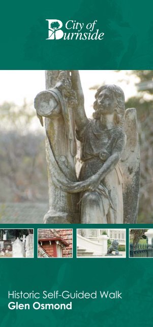
<strong>Historic</strong> <strong>Self</strong>-<strong>Guided</strong> <strong>Walk</strong><br />
<strong>Glen</strong> <strong>Osmond</strong>
GLEN OSMOND<br />
<strong>Glen</strong> <strong>Osmond</strong> was one <strong>of</strong> the earliest villages laid out in South Australia.<br />
Bounded by what is now Portrush Road, Gilles Road and extensions<br />
<strong>of</strong> Cross Road and lower Sunnyside Road, it was taken up by <strong>Osmond</strong><br />
Gilles, the first Colonial Treasurer, in 1838. In due course, his name was<br />
perpetuated by the naming <strong>of</strong> <strong>Glen</strong> <strong>Osmond</strong> and Gilles Road.<br />
The first recorded resident <strong>of</strong> <strong>Glen</strong> <strong>Osmond</strong> was Edwin Olliver, who lived<br />
in an old house at the back <strong>of</strong> St Saviour’s Church Rectory. His name<br />
appeared in the S.A. Directory for the year 1840, under ‘Country Districts’.<br />
In March, 1841, it is recorded that Gilles lived here. The building was on<br />
part <strong>of</strong> his property which he donated in 1854 for the construction <strong>of</strong> an<br />
Anglican church, known today St Saviour’s Church.<br />
That portion <strong>of</strong> <strong>Glen</strong> <strong>Osmond</strong> east <strong>of</strong> <strong>Glen</strong> <strong>Osmond</strong> Road became part<br />
<strong>of</strong> the District Council <strong>of</strong> East Torrens, which was proclaimed on 2nd<br />
June, 1853. Later, when the District Council <strong>of</strong> East Torrens was “subdivided”,<br />
it became part <strong>of</strong> the District Council <strong>of</strong> <strong>Burnside</strong>, gazetted on<br />
14 August, 1856.<br />
An extract from Bailliere’s S.A. Gazeteer, Adelaide, 1866, describes the area.<br />
The district is an agricultural one, inhabited by small farmers, gardeners, and<br />
vignerons, there being also several residences <strong>of</strong> gentlemen having business in<br />
Adelaide in the surrounding locality. The country is hilly, with fine fertile valleys<br />
and slopes, many <strong>of</strong> them in a high state <strong>of</strong> cultivation. <strong>Glen</strong> <strong>Osmond</strong> has a<br />
public pound, an Oddfellows’ Lodge (A.I.O.F) and one hotel - the Vine ... There<br />
is a silver-lead mine in the village, on the property <strong>of</strong> <strong>Osmond</strong> Gilles, Esq., who<br />
has leased it on royalty to an English company. It contains several good lodes,<br />
and many hundreds <strong>of</strong> tons <strong>of</strong> ore have been raised. There is a fine vineyard ...<br />
the wines produced being <strong>of</strong> excellent quality. A large cellar and some good<br />
wine-making machinery have been erected on the ground.<br />
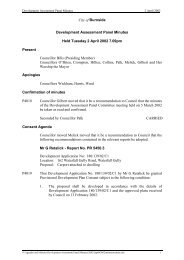
This walk starts at the carpark on the corner <strong>of</strong> Gill Terrace<br />
and the Adelaide - Crafers Highway.<br />
For information on bus routes and timetables please refer to<br />
www.adelaidemetro.com.au The distance covered by this<br />
walk is 6.7 km and takes 3 hours to complete.<br />
1 The Toll House (c1841)<br />
On an island in the middle <strong>of</strong> the road is the Toll House, built in 1841,<br />
when the colony was suffering severe financial hardship. Tolls were<br />
collected (from those travellers who did not choose to undertake a<br />
hazardous bypass route), until 1847, when the levies were abolished, it<br />
being seen as unjust that this road should be the only road in the State<br />
to be taxed. The toll-gate keeper lived in the hexagonal house, with a<br />
small garden. His hours were fixed by the Act (No. 4 <strong>of</strong> 1841) “from twelve<br />
o’clock at night to twelve o’clock <strong>of</strong> the next succeeding night”!
At the bottom <strong>of</strong> the carpark, you will find the:<br />
2 Wheal Augusta Mine Adit (1840s) - Gill Terrace/Jikara Drive,<br />
corner <strong>of</strong> Adelaide Crafers Highway next to car park on left<br />
hand side.<br />
The G. V. Allen Mining Reserve and the Wheal Augusta Mine Adit, which<br />
are part <strong>of</strong> the considerable complex <strong>of</strong> mine workings in these foothills.<br />
These were the first metalliferous mine workings in Australia. On the<br />
hillside above there is the chimney stack (not visible from here) <strong>of</strong> the<br />
<strong>Glen</strong> <strong>Osmond</strong> Smelting Works, constructed in 1849, somewhere near<br />
Jikara Drive. It was connected to the chimney by an underground stone<br />
tunnel. The smelting work ceased after a short time. The stack was later<br />
painted white and served as a guide for ships in the Gulf for many years.<br />
3 Toll Gate Motel – Adelaide Crafers Highway<br />
As you walk along the elevated footpath, you will pass a stone retaining<br />
wall beside the Toll Gate Motel. The motel was built in 1968 on the site<br />
<strong>of</strong> a hotel licensed in 1844, under the name <strong>of</strong> ‘The Miner’s Arms’. It is<br />
quite probable that this only operated until 1850, when the mines<br />
ceased to operate.<br />
4 Gurdwara Sikh Society - Adelaide Crafers Highway<br />
In recent decades this building was the Colonial Restaurant Complex but<br />
is currently occupied by the Gurdwara Sikh Society. The single storeyed<br />
section was built in about 1845, as a bakery and grocery store. The<br />
original wall ovens are still part <strong>of</strong> the building. Thomas Smith acquired<br />
the business in 1852 and his family remained here until 1968, when the<br />
Colonial Restaurant was established. Smith is reported to have operated<br />
the second <strong>Glen</strong> <strong>Osmond</strong> Post Office from this store in its early years.<br />
When you reach the start <strong>of</strong> the freeway, follow the footpath to the right<br />
and you will pass:<br />
5 Gum Tree - Portrush Road (adjacent to traffic lights)<br />
This large gum tree was planted in 1867, to celebrate the visit <strong>of</strong> the<br />
Duke <strong>of</strong> Edinburgh (see adjacent plaque).<br />
Continue onto Pridmore Road, turn right up Pridmore Road to find:<br />
6 House and Church (1883 and later) - Corner <strong>of</strong> Pridmore Road<br />
and Portrush Road<br />
The first church was built in 1862 and the Chancel later dedicated by<br />
Bishop Hammer. The adjacent Parish Hall was opened in 1898 by Mrs<br />
Henry Scott. The Rectory was built in 1883. The original church was<br />
demolished after the construction <strong>of</strong> the present church dedicated in<br />
1966 by Bishop T.T. Reed.
Continue along Pridmore Road to:<br />
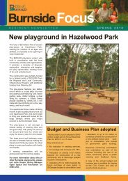
7 St Saviour’s Cemetery – corner <strong>of</strong> Highway and Cross Road<br />
The earliest graves in this cemetery date from<br />
the late 1850s, and many <strong>of</strong> <strong>Glen</strong> <strong>Osmond</strong>’s<br />
earliest identities are buried here. The<br />
cemetery is still used occasionally. The rather<br />
modest gate facing Glebe Road is in memory<br />
<strong>of</strong> Clara Langley (see No. 11).<br />
Outside the cemetery gates you will see wooden posts originally used<br />
for securing horses.<br />
Continue around the cemetery till you reach Glebe Rd. Turn left and<br />
continue along the boundary <strong>of</strong> the cemetery. Across the road you will<br />
see Elinor Tce. Cross the road and walk down Elinor Tce until you reach:<br />
8 5 Elinor Terrace<br />
This house was built in about 1928 for Elinor, the daughter <strong>of</strong> Thomas<br />
Gill, (see No. 9), and the person after whom the street was named.<br />
From here continue up Elinor Tce until you reach Woodley Rd.<br />
9 12 Woodley Road<br />
Built by the Langleys for Thomas Gill, Under-Secretary for the State in<br />
1884/85. The house, ‘Willalar’ was almost a twin <strong>of</strong> No. 9. Thomas Gill<br />
owned a considerable tract <strong>of</strong> land, down to Portrush Road, and it<br />
appears it was he who planted a row <strong>of</strong> kurrajong trees along the edge <strong>of</strong><br />
the property, facing Woodley Road, at least down to Elinor Terrace, where<br />
they still stand, despite showing signs <strong>of</strong> their great age. Elinor Terrace<br />
was apparently constructed when Gill sub-divided that portion <strong>of</strong> his land<br />
to the west <strong>of</strong> it. No. 12 was occupied by various local identities, before<br />
passing to Mr M.T. Phillipps in the 1930s, and was progressively subdivided<br />
from 1959, with five houses being built on new blocks so created.<br />
The four early Langley houses are thought to have been built here to take<br />
advantage <strong>of</strong> a solid layer <strong>of</strong> limestone rubble about 500 mm below the<br />
surface, providing a very sound foundation for building.<br />
10 9 Woodley Road<br />
Also built by the Langley clan, for George Gill, in 1884/85.<br />
In 1891/92, Mr F.G. Scammell, a solicitor, purchased the property<br />
‘Arranmore’, and Mrs Scammell occupied the house up to 1945. This is a<br />
distinctive piece <strong>of</strong> architecture, representative <strong>of</strong> its time, and maintained<br />
well to this day.
11 5 Woodley Road<br />
This was built by J.G. Langley for Charles Langley, also a building<br />
tradesman, (b. 1863, also thought to be the son <strong>of</strong> J.G.) and Clara Langley,<br />
in about 1885.<br />
The title records show that Charles Langley did not have a mortgage at<br />
any stage <strong>of</strong> his ownership, so apparently the comprehensive building<br />
capacity <strong>of</strong> the family served them all most handsomely. This block still<br />
extends through to Day Road.<br />
12 3 Woodley Road<br />
Built by Mr J.A.G. Langley, for A.D.J. (a mason) and A.G. (an ironworker)<br />
Langley, apparently sons <strong>of</strong> the elder Langley, early in the 1880s.<br />
This house remained, alone on this block going through to Day Road,<br />
until 1972, when Mr L.S. Kingsborough, its owner <strong>of</strong> many years, died. The<br />
land was sub-divided into four equal blocks, requiring the demolition <strong>of</strong><br />
the house if sold separately, but a Mr St Leger Kelly rescued the house<br />
by purchasing both blocks facing Woodley Road, and then built a small<br />
cottage, in sympathy with the style <strong>of</strong> No. 3, as accommodation for his<br />
mother-in-law.<br />
When Mr Kelly sold out later, the new owners sold the cottage as the<br />
Council was now more sympathetic to separate titles <strong>of</strong> lesser area. The<br />
new owner <strong>of</strong> No. 1B then added a top floor.<br />
13 Seymour College<br />
Wooton Lea was acquired by a Presbyterian group looking for school<br />
premises in 1921, and Presbyterian Girls College was established. From its<br />
inception, the lodge was occupied by the school’s head gardener, and in<br />
later years by other staff members.<br />
In 1977, the school became Seymour College, after the amalgamation <strong>of</strong><br />
the Presbyterian, Methodist, and Congregational Churches formed the<br />
Uniting Church.
The school grounds are, <strong>of</strong> course, private property, and not available for<br />
casual walkers, but if you now return to Gilles Road, and walk up beside<br />
the school, you will see the Junior School, the sports grounds, a large<br />
indoor sports building, tennis courts, boarding house buildings and<br />
classrooms, and eventually arrive at your starting point.<br />
The College has developed around ‘Wooton Lea’, a large, plain Georgian<br />
house <strong>of</strong> 17 rooms built in 1861 for Francis Hardy Faulding, (founder <strong>of</strong><br />
F.H. Faulding & Co) and his wife Elizabeth. Its next owner, G.S. Fowler, a<br />
principal <strong>of</strong> the firm <strong>of</strong> D.& J. Fowler, enlarged the building.<br />
Other remaining structures <strong>of</strong> note are an attractive bluestone and brick<br />
former laundry, stables and cottages, pump house with a slate ro<strong>of</strong>, and<br />
the former coach-house which is now a music room.<br />
Stately trees, including Moreton Bay figs and Queensland Kauris are<br />
features <strong>of</strong> the grounds, and form borders to the long drive.<br />
14 546 Portrush Road<br />
The former gate-house to ‘Wooton Lea’, now Seymour College. The first<br />
records <strong>of</strong> this lodge and the associated gates appear in 1877, when Mr<br />
G.S. Fowler was the owner <strong>of</strong> Wooton Lea. You will note that Fowler’s Road<br />
and the drive to the college are in the same alignment.<br />
15 548 Portrush Road<br />
Abergeldie House, formerly named ‘<strong>Glen</strong> Coola’, was built in 1861 by Max<br />
Weidenbach, a member <strong>of</strong> a large, wealthy family <strong>of</strong> nurserymen, winemakers,<br />
hotel-keepers and investors. Two <strong>of</strong> his brothers built houses<br />
alongside - One <strong>of</strong> the houses was demolished for <strong>Glen</strong>ocre Court.<br />
<strong>Glen</strong> Coola was enlarged and altered in the 1870s and then early in the<br />
1900s. Presbyterian Girls’ (now Seymour) College purchased <strong>Glen</strong> Coola<br />
in 1959, and, shortly after, it became Abergeldie Hospital. Currently, it is a<br />
holistic centre trading as Abergeldie House.<br />
16 House (1916) - 2 Wootoona Terrace<br />
Wootoona Terrace was first subdivided in 1916, and restrictions were<br />
imposed on the value and building materials <strong>of</strong> houses to ensure that<br />
substantial dwellings were built. This resulted in a street <strong>of</strong> very large<br />
dwellings on large blocks <strong>of</strong> land, with extensive gardens. The residences<br />
were built in a range <strong>of</strong> early twentieth century styles. A number <strong>of</strong> them<br />
are multi-storey.<br />
This house forms an integral part <strong>of</strong> the Wootoona Terrace <strong>Historic</strong><br />
Conservation Zone and is an excellent example <strong>of</strong> an early Federation<br />
Bungalow design in the domestic architectural development <strong>of</strong> <strong>Burnside</strong>.
This house was constructed in 1916 for F.M. and R.A. Duncan <strong>of</strong> the firm<br />
<strong>of</strong> Duncan & Fraser. This is one <strong>of</strong> the first houses built in this St George’s<br />
subdivision <strong>of</strong> the Wooton Lea Estate <strong>of</strong> Francis Faulding.<br />
17 House - 595 Portrush Road<br />
This is a bluestone residence constructed on a sloping allotment and<br />
is protected from Portrush Road by a high brick wall <strong>of</strong> a later date. The<br />
house ‘Rosebank’ was constructed in 1898 for Henry and Edith Hampson.<br />
This house is indicative <strong>of</strong> the size and style <strong>of</strong> residences which were<br />
constructed along Portrush Road at this time when the former wheat<br />
farm <strong>of</strong> the Ferguson family was first subdivided into large allotments<br />
in 1893.<br />
Return in a southerly direction & walk to Myrona Avenue.<br />
18 ‘<strong>Glen</strong>holme’ (1850) - 32 Myrona Avenue<br />
This house, together with a wooden stable, was built in 1850, by Christian<br />
Ludwig Meyer, on 6.5 acres <strong>of</strong> land, and named ‘<strong>Glen</strong>holme’. He lived here<br />
for 30 years before returning to Germany, leaving his son <strong>of</strong> the same<br />
name to carry on the occupancy. The house can best be seen from the<br />
street by looking from the footpath outside number 21.<br />
Return to Portrush Rd and walk in a northerly direction until you reach<br />
Fowlers Rd. On the corner <strong>of</strong> Portrush Rd and Fowlers Rd you will find:<br />
19 House (c1900) - 27 Fowlers Road (corner <strong>of</strong> Portrush Road)<br />
This large stone house was built at the turn <strong>of</strong> the nineteenth century,<br />
and was the home <strong>of</strong> the wine merchant A.W.R. (Rudolph) Buring. ‘Rudy’<br />
Buring was well known in the wine industry, associated up to about 1940<br />
with Buring and Sobels ‘Quelltaler’ establishment in the Clare Valley.<br />
Continue along Fowlers Road to:<br />
20 ‘Warrawee’ House (c1900) - 32 Fowlers Road<br />
Built at about the same time as the above this large stone and brick house<br />
was originally called ‘Warrawee’. It was originally constructed for Mr O.<br />
Jones, but soon passed to Mr J.F. Scrymgour.<br />
Continue down Fowlers Road.<br />
21 House (c1930) - 7 Fowlers Road<br />
This two-storey brick house built in the 1930s for Margaret and Albert<br />
McBride was a show-piece <strong>of</strong> the district for some time. They occupied<br />
it until about 1959. The next owners until about 1978 were Mr and Mrs<br />
M.T. Phillipps. The house on the west side occupies part <strong>of</strong> the original<br />
McBride land.
Continue along Fowlers Rd until you reach <strong>Glen</strong> <strong>Osmond</strong> Rd. Directly<br />
opposite you will see:<br />
22 Baptist Church (1883) - <strong>Glen</strong> <strong>Osmond</strong> Road<br />
This church was built in 1883, funded very largely by Mr G.S. Fowler,<br />
who also regularly provided funds for payment <strong>of</strong> its ministers. His son<br />
J.R. Fowler continued this support and consequently the church was<br />
commonly referred to as ‘Fowler’s Church’.<br />
Turn left onto <strong>Glen</strong> <strong>Osmond</strong> Rd and continue walking in a south easterly<br />
direction along the footpath. At the corner <strong>of</strong> Benacre Close you will find:<br />
23 Benacre Fencing - 1 Benacre Close<br />
A small length <strong>of</strong> Benacre’s original fencing remains. Original trees from<br />
Benacre grounds can be seen in various front gardens in Benacre Close.<br />
A brick wall has been built around an old Moreton Bay Fig tree a little<br />
further up the road.<br />
Continue walking in a south easterly direction along the footpath until<br />
you reach Vine Lane. Turn left up Vine Lane to:<br />
24 House (c1850) - 12 Vine Lane<br />
This house was originally three small attached cottages <strong>of</strong> two rooms<br />
each, made <strong>of</strong> bluestone and brick built in the 1850s.<br />
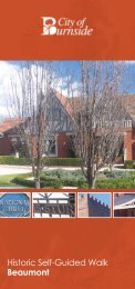
25 House (c1855) - 16 & 16A Vine Lane<br />
Built for Carl Schunke, a German migrant who<br />
first worked as a miner, then turned his talents to<br />
building and owning cottages for rental.
By 1860, a room had been added, and slates replaced the original ro<strong>of</strong>,<br />
at which stage the Rate Assessment jumped from £6 to £9! In 1862-63,<br />
large stables with an upper l<strong>of</strong>t and a feedhouse were added, and the<br />
Rate Assessment went up to £12, and by 1863 - 64 to £20.<br />
By this time, Schunke was running<br />
a thriving coach business, handily<br />
situated near the entrance to<br />
the foothills. Two more rooms<br />
were added in 1880, and 1883.<br />
John Carter, one <strong>of</strong> the Schunke’s<br />
coachmen, lived here until 1910 - 11.<br />
The stables now constitute No. 16A, which was converted to residential<br />
accomodation in the 1960’s.<br />
Now walk along Brook Avenue to Ashley Avenue.<br />
26 ‘The Mews’ (c1844) - 1A Ashley Avenue<br />
The core <strong>of</strong> this building was originally the coach-house to Benacre, and<br />
was constructed in about 1844, although a brass plate on the gate-post<br />
says 1869. This date may have been the time <strong>of</strong> some extension. Whether<br />
the top storey was included in the first building is not certain, but it seems<br />
unlikely in the light <strong>of</strong> the sequence <strong>of</strong> events at ‘Benacre’. Much <strong>of</strong> the<br />
present structure was added in the 1970s, to match the original style<br />
and materials.<br />
On the east side is one <strong>of</strong> <strong>Burnside</strong>’s many small recreation parks, Ashley<br />
Avenue Reserve.<br />
27 ‘Benacre’ (1840s) - 6 Benacre Close<br />
Adjacent to The Mews, to the south-west,<br />
is Benacre.<br />
Originally built in the 1840’s by the chemist<br />
William Bickford who also started the garden<br />
on a considerable area <strong>of</strong> land.<br />
The next owner was T.B. Strangways, followed by Thomas Graves.<br />
Thomas Graves established a fine garden containing Moreton Bay figs,<br />
pines, cedars and cypresses from such diverse places as Norway, India,<br />
Lebanon, Japan and Norfolk Island - “an assortment <strong>of</strong> trees second only<br />
to the Adelaide Botanic Garden”, according to the book History <strong>of</strong> <strong>Glen</strong><br />
<strong>Osmond</strong>, (1905).<br />
In the mid-1870s, Graves added rooms, a cellar and a top storey, before<br />
selling to Henry Scott, Mayor <strong>of</strong> Adelaide, who named it ‘Benacre’. During<br />
Scott’s tenure <strong>of</strong> some 30 years, he hosted countless social events.
During the subsequent ownership <strong>of</strong> Hon. John Lewis, M.L.C., a deer park<br />
was established. However, this was sub-divided in 1923 and now only a<br />
fraction <strong>of</strong> the original grounds remain attached to Benacre. Many <strong>of</strong> the<br />
trees remain on nearby footpaths and front lawns <strong>of</strong> new properties. Part<br />
<strong>of</strong> the early fencing <strong>of</strong> Benacre fronting <strong>Glen</strong> <strong>Osmond</strong> Road still remains.<br />
This is the end <strong>of</strong> the walking tour. To return to the starting point, walk<br />
to the end <strong>of</strong> Ashley Ave and turn right onto Brook Ave. At Vine Lane turn<br />
left and continue up until you reach Portrush Rd. Turn right onto Portrush<br />
Rd and walk along the western footpath to the major intersection at the<br />
start <strong>of</strong> the freeway. Use the pedestrian crossing and walk on the elevated<br />
footpath a short way to return to the carpark on the corner <strong>of</strong> Gill Tce and<br />
the Adelaide - Crafers Highway.<br />
An electronic copy <strong>of</strong> this historic self-guided walk and other historic walks<br />
within the <strong>City</strong> <strong>of</strong> <strong>Burnside</strong> can be found on www.burnside.sa.gov.au<br />
Every effort has been made to ensure the content <strong>of</strong> this brochure is accurate.<br />
If you have any feedback about the content, please contact us via the <strong>Burnside</strong><br />
Council website at www.burnside.sa.gov.au
GLENUNGA<br />
TREVORTON<br />
22<br />
DALASTON<br />
MOORHOUSE<br />
WASHINGTON<br />
BARR-SMITH<br />
WAY AV<br />
RIDGE AV<br />
GRANDVIEW AV<br />
21<br />
BETHUNE AV<br />
GLEN OSMOND<br />
VIEW<br />
23<br />
21<br />
LEBANON<br />
AV<br />
FOWLERS RD<br />
BENACRE<br />
AV<br />
MYRONA AV<br />
27<br />
LEWIS<br />
SPENCE AV<br />
250m<br />
Original text by David Reid<br />
Sketches by Vanessa Smith<br />
<strong>Burnside</strong> <strong>Historic</strong>al Society<br />
1st Revision August 1993<br />
2nd Revision August 2007<br />
3rd Revision February 2011<br />
26<br />
ASHLEY<br />
24<br />
TAMINGA AV<br />
AV<br />
VINE<br />
ROAD<br />
BROOK<br />
AV<br />
PORTRUSH<br />
LA<br />
QUEENS LA<br />
ROAD<br />
Published by <strong>City</strong> <strong>of</strong> <strong>Burnside</strong><br />
401 Greenhill Road, Tusmore 5065<br />
20 18 19<br />
25<br />
MONASTERY<br />
500m<br />
CRAIGHILL<br />
17<br />
CROSSING<br />
WOOTOONA<br />
15<br />
ROAD<br />
14<br />
13<br />
SEYMOUR COLLEGE<br />
GILLES RD<br />
12<br />
DAY<br />
11<br />
16<br />
WOODLEY<br />
8<br />
ELINOR TCE<br />
GLEBE<br />
6<br />
5<br />
16<br />
7<br />
10<br />
PRIDMORE RD<br />
RD<br />
BOUCAUT ST<br />
4<br />
9<br />
START<br />
RD<br />
MILNE<br />
BLYTHE<br />
LESLIE<br />
EVERARD<br />
DERRINGTON<br />
3<br />
GILL<br />
2<br />
N<br />
W E<br />
S<br />
1<br />
BAGOT<br />
JIKARA DR
401 Greenhill Road<br />
Tusmore SA 5065<br />
Telephone (08) 8366 4200<br />
Facsimile (08) 8366 4299<br />
www.burnside.sa.gov.au