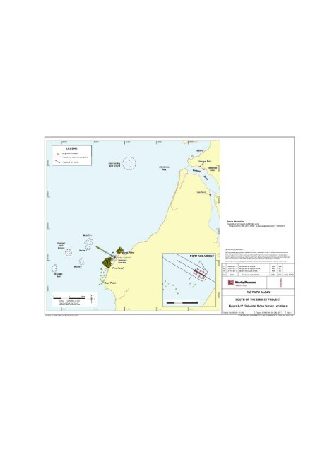
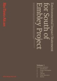
Rio Tinto AlcanEnvironmental Impact StatementSouth of <strong>Embley</strong> Project6.3 Marine HabitatsAlbatross Bay is recognised as containing environmentally important marine habitats (Baker andSheppard, 2006). Key benthic marine habitat components and their associated environmentalvalues in the vicinity of the Project marine infrastructure are discussed below and include:inshore and offshore reefs;mangroves;seagrass; andsoft sediments.6.3.1 Benthic Habitat Survey MethodsBenthic (sea floor) habitat surveys were completed within the Project area during October2007, June 2008, November 2008, June 2009 and June 2010. A combination of towed videosled and drop camera video techniques were adopted for this study, allowing the survey ofmultiple sites in a short period, providing key information to describe the distribution andstructure of benthic habitats. Towed video sled was used over low profile soft sedimenthabitats. Towed video transects covered a distance of 100m and had a field of view ofapproximately 0.5m width. Drop camera video was used over patchy reef habitat, seagrassareas and the proposed port entrance channel. The field of view was approximately 0.5m width.Vision was captured as the boat drifted, ranging from about 20m to 50m transect lengths.Detailed reef habitat surveys also utilised drop camera video methods at grid point (referSection 6.3.1.1) and captured an area of 0.5m x 0.5m using a frame. In-water surveys werenot undertaken due to potential safety risks posed by salt water crocodiles in the area. Refer toFigure 6-17 and Table 6-2 for survey locations and techniques.6.3.1.1 Detailed Reef Habitat SurveysDetailed drop camera video and towed video sled techniques were used between Pera Headand Boyd Point (inclusive) to systematically survey sponge, soft coral and fringing hard coralreef habitats in the immediate vicinity of the proposed port development during October 2007and June 2008. These techniques assess the percentage of live benthic cover, provide diversityestimates via still imagery analysis and allow mapping of habitat distribution. Detailed samplinggrids incorporating 125m spacing were applied over Pera Head and Boyd Point, facilitating theinspection of approximately 415 benthic survey sites. The Coral Point Count with ExcelExtensions software (CPCe Version 3.4) was used to analyse still images obtained from thevideo footage. Benthic community cover and diversity was assessed by randomly locating 20points over each image. The underlying benthic biota from these 20 points was classified asfollows:coralmassive coral, branching coral, tabulate coral, encrusting coral, foliose coral;gorgonian coral;hydroids;sponges;soft coral;algae brown macroalgae, green macroalgae, red macroalgae, coralline algae,seagrass; andother biota anemone, ascidians, holuthurians,zoanthid, nudibranch, bryozoan, crustacean, sea pen.sipunculid,bivalve, gastropod,Section 6 Marine Page 6-16
Pera,550000 1 560000 1 570000 1 580000i,,/\--J'--`21ALEGENDDrop video locationsTowed sled video transect pathsWEIPA.....,.... Proposed port facilityAlbatross Bay\ Spoil Ground .ss'---AlbatrossBayHumbug Point-.. ,.. Hornibrook<strong>Embley</strong>PointHey Point------.,- 1./Source InformationConceptual port layout and dredge areaExtracted from SOK-2231-00001_Q.dwg supplied by client 19/05/2010Mound 3---Proposed, i,..--, '. .. AAS'f .Mound 2--A,,Ground. i ._...,Mound 1, 1I Opk...... .."A ANine MileA AReefAA0 5 10kmSCALE 1200,000 (at A3)Map Grid of Australia Zone 54Geocentric Datum of Australia 1994NW4ESAhud PointJHeadBoyd PointEFER TO INSETProposedPort AreaAAAAAAA0 1km1 550000 1 560000 I570000 1580000 1590000APORT AREA INSET A 0A°CBAThis map incorporates. a which is0 commonwealth of Australia (Geoscience Australia) 2011The commonwealth give no warranty regarding the accuracy, completeness, currency or suitability for a, particular purpose.WorleyParsons Servic s Pty LtdWhile every care is take . ensure the accuracy of this data, vvorleyParsons makes no representation or warranties about itsreliability, com leteness or suitability for a, particular purpose and disclaims all responsibilit and all liability (includingwithout ation liability n the for all expenses, losses, damages (including indirect or cons. en.I damage) and costswhch might b e irr. ncucares ult of the data being inaccurate or incomplete in a, way and for any r asonRef er to K A17.305-146 ,,I,..map,1467,4 00 EN DAL 0053 E(videoSurveyLocations) wor for prey i04/04/201126/07/201021/07/2010Re-issued for reviewRe-issued for squad checkIssued for squad checkKMNAKMus version of mapRev Dale Revision Description DRN CHK ENG APPDrTiWorleyParsonsresources &energyRIO TINTO ALCANSOUTH OF THE EMBLEY PROJECTMMMZMZ1iaFigure 6-17 Sub-tidal Video Survey LocationsProject No: 301 001 -01 069 Figure: 01069 00 GM DAL 0017 Rev: CCompiled by BRISBANE GEOMATICS SECTIONKATAG01001 -01069 \ GMTAL\ 01069 00 GM EN 0017 C(Sub tidal_Video).wor