List of Satellite Missions - ceos eo handbook
List of Satellite Missions - ceos eo handbook
List of Satellite Missions - ceos eo handbook
- No tags were found...
Create successful ePaper yourself
Turn your PDF publications into a flip-book with our unique Google optimized e-Paper software.
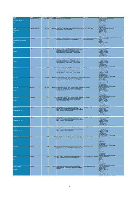
Mission Status Launch Date EOL Date Applications Instruments Orbit Details & URL<br />
SCD-2<br />
Currently being flown 22 Oct 1998 Dec 2012 Data collection and communication. DCS Type: Inclined, non-sun-synchronous<br />
Altitude: 750 km<br />
Data Collecting <strong>Satellite</strong> 2<br />
Period: 100 mins<br />
Inclination: 25 deg<br />
INPE<br />
Repeat cycle:<br />
LST:<br />
Longitude (if g<strong>eo</strong>):<br />
Asc/desc: TBD<br />
URL: www.inpe.br<br />
SCISAT-1<br />
Currently being flown 12 Aug 2003 Mar 2015 To improve our understanding <strong>of</strong> the depletion <strong>of</strong> the ozone layer, ACE-FTS, MAESTRO<br />
Type: Inclined, non-sun-synchronous<br />
particularly over Canada and the Arctic.<br />
Altitude: 650 km<br />
SCISAT-I/ACE<br />
Period: 97.7 mins<br />
Inclination: 74 deg<br />
CSA<br />
Repeat cycle: 365 days<br />
LST:<br />
Longitude (if g<strong>eo</strong>):<br />
Asc/desc: N/A<br />
URL: www.asc-csa.gc.ca/eng/satellites/scisat/default.asp<br />
SCLP<br />
Considered 2030 2033 Phase-3 DS Mission, launch order unknown, 3-year nominal Ku and X-band radars (SCLP), K Type: Sun-synchronous<br />
mission. Snow accumulation for fresh water availability.<br />
band radiometers (SCLP)<br />
Altitude:<br />
Snow and Cold Land Processes<br />
Period:<br />
Inclination:<br />
NASA<br />
Repeat cycle: 15 days<br />
LST:<br />
Longitude (if g<strong>eo</strong>):<br />
Asc/desc:<br />
URL: decadal.gsfc.nasa.gov/sclp.html<br />
Sentinel-1 A<br />
Approved May 2013 Aug 2020 Providing continuity <strong>of</strong> C-band SAR data for operational C-Band SAR<br />
Type: Sun-synchronous<br />
applications notably in the following areas: monitoring <strong>of</strong> sea ice<br />
Altitude: 693 km<br />
zones and the arctic environment, surveillance <strong>of</strong> marine<br />
Period: 98.74 mins<br />
ESA / EC<br />
environment, monitoring <strong>of</strong> land surface motion risks and<br />
Inclination: 98.19 deg<br />
mapping in support <strong>of</strong> humanitarian aid in crisis situations.<br />
Repeat cycle: 12 days<br />
LST: 18:00<br />
Longitude (if g<strong>eo</strong>):<br />
Asc/desc: Ascending<br />
URL: www.esa.int/esaLP/LPgmes.html<br />
Sentinel-1 B<br />
Approved Jan 2015 May 2022 Providing continuity <strong>of</strong> C-band SAR data for operational C-Band SAR<br />
Type: Sun-synchronous<br />
applications notably in the following areas: monitoring <strong>of</strong> sea ice<br />
Altitude: 693 km<br />
zones and the arctic environment, surveillance <strong>of</strong> marine<br />
Period: 98.74 mins<br />
ESA / EC<br />
environment, monitoring <strong>of</strong> land surface motion risks and<br />
Inclination: 98.19 deg<br />
mapping in support <strong>of</strong> humanitarian aid in crisis situations.<br />
Repeat cycle: 12 days<br />
LST: 18:00<br />
Longitude (if g<strong>eo</strong>):<br />
Asc/desc: Ascending<br />
URL: www.esa.int/esaLP/LPgmes.html<br />
Sentinel-1 C<br />
Considered 2019 2026 Providing continuity <strong>of</strong> C-band SAR data for operational C-Band SAR<br />
Type: Sun-synchronous<br />
applications notably in the following areas: monitoring <strong>of</strong> sea ice<br />
Altitude: 693 km<br />
zones and the arctic environment, surveillance <strong>of</strong> marine<br />
Period: 98.74 mins<br />
ESA / EC<br />
environment, monitoring <strong>of</strong> land surface motion risks and<br />
Inclination: 98.19 deg<br />
mapping in support <strong>of</strong> humanitarian aid in crisis situations.<br />
Repeat cycle: 12 days<br />
LST: 18:00<br />
Longitude (if g<strong>eo</strong>):<br />
Asc/desc: Ascending<br />
URL: www.esa.int/esaLP/LPgmes.html<br />
Sentinel-2 A<br />
Approved Nov 2013 Feb 2021 Supporting land monitoring related services, including: generation MSI (Sentinel-2)<br />
Type: Sun-synchronous<br />
<strong>of</strong> generic land cover maps, risk mapping and fast images for<br />
Altitude: 786 km<br />
disaster relief, generation <strong>of</strong> leaf coverage leaf chlorophyll content<br />
Period: 100.7 mins<br />
ESA / EC<br />
and leaf water content.<br />
Inclination: 98.62 deg<br />
Repeat cycle: 10 days<br />
LST: 10:30<br />
Longitude (if g<strong>eo</strong>):<br />
Asc/desc: Descending<br />
URL: www.esa.int/esaLP/LPgmes.html<br />
Sentinel-2 B<br />
Approved May 2015 Aug 2022 Supporting land monitoring related services, including: generation MSI (Sentinel-2)<br />
Type: Sun-synchronous<br />
<strong>of</strong> generic land cover maps, risk mapping and fast images for<br />
Altitude: 786 km<br />
disaster relief, generation <strong>of</strong> leaf coverage leaf chlorophyll content<br />
Period: 100.7 mins<br />
ESA / EC<br />
and leaf water content.<br />
Inclination: 98.62 deg<br />
Repeat cycle: 10 days<br />
LST: 10:30<br />
Longitude (if g<strong>eo</strong>):<br />
Asc/desc: Descending<br />
URL: www.esa.int/esaLP/LPgmes.html<br />
Sentinel-2 C<br />
Considered 2020 2027 Supporting land monitoring related services, including: generation MSI (Sentinel-2)<br />
Type: Sun-synchronous<br />
<strong>of</strong> generic land cover maps, risk mapping and fast images for<br />
Altitude: 786 km<br />
disaster relief, generation <strong>of</strong> leaf coverage, leaf chlorophyll<br />
Period: 100.7 mins<br />
ESA / EC<br />
content and leaf water content.<br />
Inclination: 98.62 deg<br />
Repeat cycle: 10 days<br />
LST: 10:30<br />
Longitude (if g<strong>eo</strong>):<br />
Asc/desc: Descending<br />
URL: www.esa.int/esaLP/LPgmes.html<br />
Sentinel-3 A<br />
Approved Oct 2013 Mar 2021 Supporting global land and ocean monitoring services, in OLCI, SLSTR, SRAL<br />
Type: Sun-synchronous<br />
particular: sea/land colour data and surface temperature; sea<br />
Altitude: 814 km<br />
surface and land ice topography; coastal zones, inland water and<br />
Period: 100 mins<br />
ESA / EUMETSAT / EC<br />
sea ice topography; vegetation products.<br />
Inclination: 98.65 deg<br />
Repeat cycle: 27 days<br />
LST: 10:00<br />
Longitude (if g<strong>eo</strong>):<br />
Asc/desc: Descending<br />
URL: www.esa.int/esaLP/LPgmes.html<br />
Sentinel-3 B<br />
Approved Oct 2014 Feb 2022 Supporting global land and ocean monitoring services, in OLCI, SLSTR, SRAL<br />
Type: Sun-synchronous<br />
particular: sea/land colour data and surface temperature; sea<br />
Altitude: 814 km<br />
surface and land ice topography; coastal zones, inland water and<br />
Period: 100 mins<br />
ESA / EUMETSAT / EC<br />
sea ice topography; vegetation products.<br />
Inclination: 98.65 deg<br />
Repeat cycle: 27 days<br />
LST: 10:00<br />
Longitude (if g<strong>eo</strong>):<br />
Asc/desc: Ascending<br />
URL: www.esa.int/esaLP/LPgmes.html<br />
Sentinel-3 C<br />
Considered 2020 2027 Supporting global land and ocean monitoring services, in OLCI, SLSTR, SRAL<br />
Type: Sun-synchronous<br />
particular: sea/land colour data and surface temperature; sea<br />
Altitude: 814 km<br />
surface and land ice topography; coastal zones, inland water and<br />
Period: 100 mins<br />
ESA / EUMETSAT / EC<br />
sea ice topography; vegetation products.<br />
Inclination: 98.65 deg<br />
Repeat cycle: 27 days<br />
LST: 10:00<br />
Longitude (if g<strong>eo</strong>):<br />
Asc/desc: Ascending<br />
URL: www.esa.int/esaLP/LPgmes.html<br />
Sentinel-4 A<br />
Planned 2018 2027 Supporting European atmospheric composition and air quality UVN (Sentinel-4), IRS<br />
Type: G<strong>eo</strong>stationary<br />
monitoring services. The Sentinel-4 A mission is carried on MTG<br />
Altitude:<br />
S1.<br />
Period:<br />
ESA / EC<br />
Inclination:<br />
Repeat cycle:<br />
LST:<br />
Longitude (if g<strong>eo</strong>): 0<br />
Asc/desc: N/A<br />
URL: www.esa.int/esaLP/LPgmes.html<br />
Sentinel-4 B<br />
Planned 2024 2033 Supporting European atmospheric composition and air quality UVN (Sentinel-4), IRS<br />
Type: G<strong>eo</strong>stationary<br />
monitoring services. The Sentinel-4 B mission is carried on MTG<br />
Altitude:<br />
S2.<br />
Period:<br />
ESA / EC<br />
Inclination:<br />
Repeat cycle:<br />
LST:<br />
Longitude (if g<strong>eo</strong>): 0<br />
Asc/desc: N/A<br />
URL: www.esa.int/esaLP/LPgmes.html<br />
Sentinel-5<br />
Planned 2019 2026 In early stages <strong>of</strong> mission definition. Other payloads will be IRS, METimage, UVNS (Sentinel-5) Type: Sun-synchronous<br />
added. The Sentinel-5 mission is carried on EPS-SG-a.<br />
Altitude:<br />
Period:<br />
ESA<br />
Inclination:<br />
Repeat cycle:<br />
LST:<br />
Longitude (if g<strong>eo</strong>):<br />
Asc/desc: N/A<br />
URL: www.esa.int/esaLP/LPgmes.html<br />
Sentinel-5 precursor<br />
Approved Oct 2014 Jan 2020 Supporting global atmospheric composition and air quality UVNS (Sentinel-5 precursor) Type: Sun-synchronous<br />
monitoring services. It will bridge the gap between Envisat and<br />
Altitude: 824 km<br />
Sentinel-5.<br />
Period: 17 mins<br />
ESA / NSO<br />
Inclination: 98.742 deg<br />
Repeat cycle:<br />
LST: 13:30<br />
Longitude (if g<strong>eo</strong>):<br />
Asc/desc: Ascending<br />
URL: www.esa.int/esaLP/LPgmes.html<br />
18


