List of Satellite Missions - ceos eo handbook
List of Satellite Missions - ceos eo handbook
List of Satellite Missions - ceos eo handbook
- No tags were found...
You also want an ePaper? Increase the reach of your titles
YUMPU automatically turns print PDFs into web optimized ePapers that Google loves.
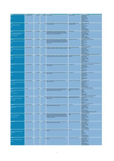
Mission Status Launch Date EOL Date Applications Instruments Orbit Details & URL<br />
Sich-2<br />
Currently being flown 17 Aug 2011 Aug 2015 Land observation. MSS (Sich), MIRS Type: Sun-synchronous<br />
Altitude: 668 km<br />
Period: 98 mins<br />
NSAU<br />
Inclination: 98 deg<br />
Repeat cycle: 5 days<br />
LST: 10:50<br />
Longitude (if g<strong>eo</strong>):<br />
Asc/desc: Descending<br />
URL:<br />
SMAP<br />
Planned 2014 2017 Late 2014 launch expected, 3-year nominal mission life. Global L-band Radar (SMAP), L-band Type: Sun-synchronous<br />
soil moisture mapping.<br />
Radiometer (SMAP)<br />
Altitude: 685 km<br />
Soil Moisture Active Passive<br />
Period:<br />
Inclination: 98 deg<br />
NASA<br />
Repeat cycle:<br />
LST: 18:00<br />
Longitude (if g<strong>eo</strong>):<br />
Asc/desc: Ascending<br />
URL: smap.jpl.nasa.gov/<br />
SMOS<br />
Currently being flown 02 Nov 2009 Nov 2012 Overall objectives are to provide global observations <strong>of</strong> two MIRAS (SMOS)<br />
Type: Sun-synchronous<br />
crucial variables for modelling the weather and climate, soil<br />
Altitude: 758 km<br />
Soil Moisture and Ocean Salinity (Earth<br />
moisture and ocean salinity. It will also monitor the vegetation<br />
Period: 100.075 mins<br />
Explorer Opportunity Mission)<br />
water content, snow cover and ice structure.<br />
Inclination: 98.44 deg<br />
Repeat cycle: 23 days<br />
ESA / CDTI / CNES<br />
LST: 6:00<br />
Longitude (if g<strong>eo</strong>):<br />
Asc/desc: Ascending<br />
URL: earth.esa.int/SMOS/<br />
SORCE<br />
Currently being flown 25 Jan 2003 Sep 2013 5-year nominal mission life, currently in extended operations. SOLSTICE, SIM, TIM, XPS Type: Inclined, non-sun-synchronous<br />
Continues the precise, long-term measurements <strong>of</strong> total solar<br />
Altitude: 600 km<br />
Solar Radiation and Climate Experiment<br />
irradiance at UV and VNIR wavelengths. Daily measurements <strong>of</strong><br />
Period:<br />
solar UV. Precise measurements <strong>of</strong> visible solar irradiance for<br />
Inclination: 40 deg<br />
NASA<br />
climate studies.<br />
Repeat cycle:<br />
LST:<br />
Longitude (if g<strong>eo</strong>):<br />
Asc/desc:<br />
URL: lasp.colorado.edu/sorce/<br />
SPOT-4<br />
Currently being flown 24 Mar 1998 Jun 2013 Cartography, land surface, agriculture and forestry, civil planning HRVIR, VEGETATION, DORIS Type: Sun-synchronous<br />
and mapping, digital terrain models, environmental monitoring. (SPOT)<br />
Altitude: 832 km<br />
<strong>Satellite</strong> Pour l'Observation de la Terre - 4<br />
Period: 101 mins<br />
Inclination: 98.7 deg<br />
CNES<br />
Repeat cycle: 26 days<br />
LST: 10:30<br />
Longitude (if g<strong>eo</strong>):<br />
Asc/desc: Descending<br />
URL: www.spot.com/home/system/introsat/welcome.htm<br />
SPOT-5<br />
Currently being flown 04 May 2002 Jun 2014 Cartography, land surface, agriculture and forestry, civil planning HRG, VEGETATION, HRS, DORIS- Type: Sun-synchronous<br />
and mapping, digital terrain models, environmental monitoring. NG (SPOT)<br />
Altitude: 832 km<br />
<strong>Satellite</strong> Pour l'Observation de la Terre - 5<br />
Period: 101 mins<br />
Inclination: 98.7 deg<br />
CNES<br />
Repeat cycle: 26 days<br />
LST: 10:30<br />
Longitude (if g<strong>eo</strong>):<br />
Asc/desc: Descending<br />
URL:<br />
www.spotimage.fr/home/system/future/spot5/welcome.htm<br />
STARLETTE<br />
Currently being flown 06 Feb 1975 Dec 2050 G<strong>eo</strong>desy/gravity study <strong>of</strong> the Earth’s gravitational field and its Laser Reflectors<br />
Type: Inclined, non-sun-synchronous<br />
temporal variations.<br />
Altitude: 812 km<br />
Period: 104 mins<br />
CNES<br />
Inclination: 49.83 deg<br />
Repeat cycle:<br />
LST:<br />
Longitude (if g<strong>eo</strong>):<br />
Asc/desc: N/A<br />
URL:<br />
STELLA<br />
Currently being flown 30 Sep 1993 Dec 2050 G<strong>eo</strong>desy/gravity study <strong>of</strong> the Earth’s gravitational field and its Laser Reflectors<br />
Type: Inclined, non-sun-synchronous<br />
temporal variations.<br />
Altitude: 830 km<br />
Period: 101 mins<br />
CNES<br />
Inclination: 98 deg<br />
Repeat cycle:<br />
LST:<br />
Longitude (if g<strong>eo</strong>):<br />
Asc/desc: N/A<br />
URL:<br />
Suomi NPP<br />
Currently being flown 28 Oct 2011 Oct 2016 5-year nominal mission life. Operational polar weather and CrIS, CERES, VIIRS, ATMS, OMPS Type: Sun-synchronous<br />
climate measurements.<br />
Altitude: 824 km<br />
Suomi National Polar-orbiting Partnership<br />
Period: 101 mins<br />
Inclination:<br />
NASA / NOAA<br />
Repeat cycle: 16 days<br />
LST: 13:30<br />
Longitude (if g<strong>eo</strong>):<br />
Asc/desc: Ascending<br />
URL: jointmission.gsfc.nasa.gov/<br />
Swarm<br />
Approved Jul 2012 Oct 2016 To provide the best ever survey <strong>of</strong> the g<strong>eo</strong>magnetic field and its Laser Reflectors (ESA), ASM, VFM, Type: Inclined, non-sun-synchronous<br />
temporal evolution, and gain new insights into improving our STR, EFI, ACC, GPS Receiver Altitude:<br />
Earth's Magnetic Field and Environment<br />
knowledge <strong>of</strong> the Earth’s interior and climate.<br />
(Swarm)<br />
Period:<br />
Explorers<br />
Inclination:<br />
Repeat cycle:<br />
ESA / CNES / CSA<br />
LST:<br />
Longitude (if g<strong>eo</strong>):<br />
Asc/desc: N/A<br />
URL: www.esa.int/export/esaLP/swarm.html<br />
SWOT<br />
Considered 2019 2022 Phase-2 DS Mission, launch order unknown, 3-year nominal CO Sensor (ASCENDS), Ka-band Type: Inclined, non-sun-synchronous<br />
mission. Ocean, lake, and river water levels for ocean and inland Radar INterferometer (KaRIN) Altitude: 970 km<br />
Surface Water Ocean Topography<br />
water dynamics.<br />
Period:<br />
Inclination: 78 deg<br />
NASA / CNES<br />
Repeat cycle: 22 days<br />
LST:<br />
Longitude (if g<strong>eo</strong>):<br />
Asc/desc:<br />
URL: bprc.osu.edu/water/index.php<br />
TanDEM-X<br />
Currently being flown 21 Jun 2010 Dec 2015 Cartography, land surface, civil planning and mapping, digital X-Band SAR<br />
Type: Sun-synchronous<br />
terrain models, environmental monitoring.<br />
Altitude: 514 km<br />
TerraSAR-X Add-on for Digital Elevation<br />
Period: 94.85 mins<br />
Measurements<br />
Inclination: 97.4 deg<br />
Repeat cycle: 11 days<br />
DLR<br />
LST:<br />
Longitude (if g<strong>eo</strong>):<br />
Asc/desc: Ascending<br />
URL: www.dlr.de/hr/desktopdefault.aspx/tabid-<br />
2317/3669_read-5488/<br />
Terra<br />
Currently being flown 18 Dec 1999 Sep 2013 6-year nominal mission life, currently in extended operations. MOPITT, MODIS, MISR, CERES, Type: Sun-synchronous<br />
Atmospheric dynamics/water and energy cycles, atmospheric ASTER<br />
Altitude: 705 km<br />
Terra (formerly EOS AM-1)<br />
chemistry, physical and radiative properties <strong>of</strong> clouds, air-land<br />
Period: 99 mins<br />
exchanges <strong>of</strong> energy, carbon and water, vertical pr<strong>of</strong>iles <strong>of</strong> CO<br />
Inclination: 98.2 deg<br />
NASA / METI / CSA<br />
and methane vulcanology.<br />
Repeat cycle: 16 days<br />
LST: 10:30<br />
Longitude (if g<strong>eo</strong>):<br />
Asc/desc: Descending<br />
URL: terra.nasa.gov/<br />
TerraSAR-X<br />
Currently being flown 15 Jun 2007 Dec 2013 Cartography, land surface, civil planning and mapping, digital X-Band SAR, GPSRO (Terra-SAR) Type: Sun-synchronous<br />
terrain models, environmental monitoring.<br />
Altitude: 514 km<br />
Period: 94.85 mins<br />
DLR<br />
Inclination: 97.4 deg<br />
Repeat cycle: 11 days<br />
LST: 18:00<br />
Longitude (if g<strong>eo</strong>):<br />
Asc/desc: Ascending<br />
URL: www.terrasar.de/<br />
TES<br />
Currently being flown 22 Oct 2001 Dec 2012 For demonstrating many satellite technologies for future Cartosat TES PAN<br />
Type: Sun-synchronous<br />
satellites.<br />
Altitude:<br />
Technology Experimental <strong>Satellite</strong> on<br />
Period:<br />
Cartography<br />
Inclination:<br />
Repeat cycle:<br />
ISRO<br />
LST:<br />
Longitude (if g<strong>eo</strong>):<br />
Asc/desc: Descending<br />
URL: www.isro.org/<br />
THEOS<br />
Currently being flown 01 Oct 2008 Oct 2013 Earth resources, land surface and disaster monitoring, civil PAN (GISTDA), MS (GISTDA) Type: Sun-synchronous<br />
planning.<br />
Altitude: 822 km<br />
Thailand Earth Observation System<br />
Period: 101 mins<br />
Inclination: 98.7 deg<br />
GISTDA<br />
Repeat cycle: 26 days<br />
LST: 10:00<br />
Longitude (if g<strong>eo</strong>):<br />
Asc/desc: Descending<br />
URL: www.gistda.or.th<br />
19


