

List of Satellite Missions - ceos eo handbook
List of Satellite Missions - ceos eo handbook
List of Satellite Missions - ceos eo handbook
- No tags were found...

Create successful ePaper yourself
Turn your PDF publications into a flip-book with our unique Google optimized e-Paper software.
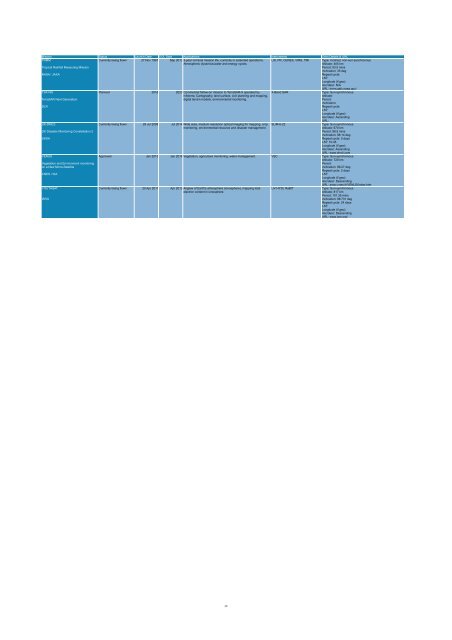
Mission Status Launch Date EOL Date Applications Instruments Orbit Details & URL<br />
TRMM<br />
Currently being flown 27 Nov 1997 Sep 2013 3-year nominal mission life, currently in extended operations. LIS, PR, CERES, VIRS, TMI Type: Inclined, non-sun-synchronous<br />
Atmospheric dynamics/water and energy cycles.<br />
Altitude: 405 km<br />
Tropical Rainfall Measuring Mission<br />
Period: 93.5 mins<br />
Inclination: 35 deg<br />
NASA / JAXA<br />
Repeat cycle:<br />
LST:<br />
Longitude (if g<strong>eo</strong>):<br />
Asc/desc: N/A<br />
URL: trmm.gsfc.nasa.gov/<br />
TSX-NG<br />
Planned 2016 2023 Commercial follow-on mission to TerraSAR-X operated by X-Band SAR<br />
Type: Sun-synchronous<br />
Infoterra. Cartography, land surface, civil planning and mapping,<br />
Altitude:<br />
TerraSAR Next Generation<br />
digital terrain models, environmental monitoring.<br />
Period:<br />
Inclination:<br />
DLR<br />
Repeat cycle:<br />
LST:<br />
Longitude (if g<strong>eo</strong>):<br />
Asc/desc: Ascending<br />
URL:<br />
UK-DMC2<br />
Currently being flown 29 Jul 2009 Jul 2014 Wide area, medium resolution optical imaging for mapping, crop SLIM-6-22<br />
Type: Sun-synchronous<br />
monitoring, environmental resource and disaster management.<br />
Altitude: 670 km<br />
UK Disaster Monitoring Constellation 2<br />
Period: 98.5 mins<br />
Inclination: 98.14 deg<br />
UKSA<br />
Repeat cycle: 5 days<br />
LST: 10:45<br />
Longitude (if g<strong>eo</strong>):<br />
Asc/desc: Ascending<br />
URL: www.dmcii.com<br />
VENUS<br />
Approved Jan 2013 Jan 2016 Vegetation, agriculture monitoring, water management. VSC Type: Sun-synchronous<br />
Altitude: 720 km<br />
Vegetation and Environment monitoring<br />
Period:<br />
on a New Micro-<strong>Satellite</strong><br />
Inclination: 98.27 deg<br />
Repeat cycle: 2 days<br />
CNES / ISA<br />
LST:<br />
Longitude (if g<strong>eo</strong>):<br />
Asc/desc: Descending<br />
URL: smsc.cnes.fr/VENUS/index.htm<br />
YOUTHSAT<br />
Currently being flown 20 Apr 2011 Apr 2013 Airglow <strong>of</strong> Earth's atmosphere (ionosphere), mapping total LiV HYSI, RaBIT<br />
Type: Sun-synchronous<br />
electron content in ionosphere.<br />
Altitude: 817 km<br />
Period: 101.35 mins<br />
ISRO<br />
Inclination: 98.731 deg<br />
Repeat cycle: 24 days<br />
LST:<br />
Longitude (if g<strong>eo</strong>):<br />
Asc/desc: Descending<br />
URL: www.isro.org/<br />
20


